Envira: Difference between revisions
Appearance
Content deleted Content added
Rescuing 1 sources and tagging 0 as dead. #IABot (v1.2.7.1) |
Specific link List of municipalities in Amazonas there Tags: Mobile edit Mobile web edit |
||
| (12 intermediate revisions by 11 users not shown) | |||
| Line 1: | Line 1: | ||
{{Infobox settlement |
{{Infobox settlement |
||
|name = Envira |
|name = Envira |
||
|settlement_type = [[ |
|settlement_type = [[List of municipalities in Amazonas|Municipality]] |
||
|official_name = |
|official_name = |
||
|image_skyline = |
|image_skyline = |
||
|imagesize = |
|imagesize = |
||
|image_caption = |
|image_caption = |
||
|image_flag = |
|image_flag = Bandeira de Envira.svg |
||
|image_seal = |
|image_seal = |
||
|image_map = Amazonas Municip Envira.svg |
|image_map = Amazonas Municip Envira.svg |
||
| Line 12: | Line 12: | ||
|map_caption = Location of the municipality inside Amazonas |
|map_caption = Location of the municipality inside Amazonas |
||
|pushpin_map = Brazil |
|pushpin_map = Brazil |
||
| |
|pushpin_mapsize = 250 |
||
|pushpin_map_caption = Location in Brazil |
|pushpin_map_caption = Location in Brazil |
||
| ⚫ | |||
|coordinates_display = inline, title |
|||
|coordinates_region = BR |
|||
| ⚫ | |||
|subdivision_type1 = [[Regions of Brazil|Region]] |
|subdivision_type1 = [[Regions of Brazil|Region]] |
||
|subdivision_type2 = [[States of Brazil|State]] |
|subdivision_type2 = [[States of Brazil|State]] |
||
| Line 26: | Line 24: | ||
|area_note = |
|area_note = |
||
|area_total_km2 = |
|area_total_km2 = |
||
|population_as_of = |
|population_as_of = 2020 |
||
|population_total = |
|population_total = 20,393 |
||
|population_footnotes = |
|population_footnotes = |
||
|timezone = [[Time in Brazil| |
|timezone = [[Time in Brazil|ACT]] |
||
|utc_offset = |
|utc_offset = −5 |
||
|timezone_DST = |
|timezone_DST = |
||
|utc_offset_DST = |
|utc_offset_DST = |
||
|coordinates = {{coord|7|25|58|S|70|1|22|W|region:BR|display=inline,title}} |
|||
|latd=7 |latm= 25|lats=58 |latNS=S |longd=70|longm=1 |longs=22 | longEW=W |
|||
|elevation_m = |
|elevation_m = |
||
|postal_code_type = |
|postal_code_type = |
||
| Line 44: | Line 42: | ||
}} |
}} |
||
'''Envira''' is a [[municipality]] |
'''Envira''' is a [[Municipalities of Brazil|municipality]] in the [[States of Brazil|Brazilian state]] of [[Amazonas (Brazilian state)|Amazonas]]. Its population was 20,393 as of 2020,<ref>[https://cidades.ibge.gov.br/brasil/am/envira/panorama IBGE 2020]</ref> and its area is {{convert|13369|sqkm|abbr=on}}.<ref>[[Brazilian Institute of Geography and Statistics|IBGE]] - {{cite web|url=http://www.ibge.gov.br/cidadesat/default.php |title=Archived copy |access-date=2014-08-03 |url-status=dead |archive-url=https://web.archive.org/web/20070109005631/http://www.ibge.gov.br/cidadesat/default.php |archive-date=2007-01-09 }}</ref> |
||
==References== |
==References== |
||
{{reflist}} |
{{reflist}} |
||
| ⚫ | |||
{{Municipalities of Amazonas}} |
{{Municipalities of Amazonas}} |
||
[[Category:Municipalities in Amazonas (Brazilian state)]] |
[[Category:Municipalities in Amazonas (Brazilian state)]] |
||
| ⚫ | |||
Latest revision as of 20:26, 19 August 2024
Envira | |
|---|---|
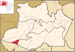
 Location of the municipality inside Amazonas | |
| Coordinates: 7°25′58″S 70°1′22″W / 7.43278°S 70.02278°W | |
| Country | |
| Region | North |
| State | |
| Population (2020) | |
• Total | 20,393 |
| Time zone | UTC−5 (ACT) |
Envira is a municipality in the Brazilian state of Amazonas. Its population was 20,393 as of 2020,[1] and its area is 13,369 km2 (5,162 sq mi).[2]
References
[edit]- ^ IBGE 2020
- ^ IBGE - "Archived copy". Archived from the original on 2007-01-09. Retrieved 2014-08-03.
{{cite web}}: CS1 maint: archived copy as title (link)


