Hvítavatn: Difference between revisions
Appearance
Content deleted Content added
mNo edit summary |
m IPA-xx deprecated |
||
| (30 intermediate revisions by 24 users not shown) | |||
| Line 1: | Line 1: | ||
{{Unreferenced|date=December 2009}} |
|||
| ⚫ | |||
{{Infobox lake |
|||
| ⚫ | |||
|image = |
|||
|caption = |
|||
|image_bathymetry = |
|||
|caption_bathymetry = |
|||
|location = |
|||
|coords = {{Coord|64|07|N|17|33|W|region:IS_type:waterbody|display=inline,title}} |
|||
|type = |
|||
|inflow = |
|||
|outflow = |
|||
|catchment = |
|||
|basin_countries = Iceland |
|||
|length = |
|||
|width = |
|||
|area = |
|||
|depth = |
|||
|max-depth = |
|||
|volume = |
|||
|residence_time = |
|||
|shore = |
|||
|elevation = |
|||
|islands = |
|||
|cities = |
|||
<!-- Map --> |
|||
| pushpin_map = Iceland |
|||
| pushpin_label_position = |
|||
| pushpin_map_alt = Location of Hvítavatn in Iceland. |
|||
| pushpin_map_caption = |
|||
<!-- Below --> |
|||
| website = |
|||
| reference = |
|||
}} |
|||
| ⚫ | '''Hvítavatn''' ({{IPA|is|ˈkʰviːtaˌvahtn̥, ˈxʷiː-|audio=Hvítavatn pronunciation.ogg}}) is a small [[lake]] in the southern [[Highlands of Iceland]]. It is situated between [[Sídujökull]] and [[Skeiðarájökull]], two of the southern arms of the big glacier [[Vatnajökull]], and lies 15 km to the north of the infamous [[Skeiðará]] sander. |
||
There are some lakes and rivers with the |
There are some lakes and rivers with the adjective ''hvíta'' (meaning ''white'') in their name in [[Iceland]]. This comes from the origin of most of the freshwater on this island: the [[glacier]]s. |
||
==See also== |
|||
*[[List of lakes of Iceland]] |
|||
| ⚫ | |||
| ⚫ | |||
[[fr:Hvítavatn]] |
|||
{{Lakes of Iceland}} |
|||
{{DEFAULTSORT:Hvitavatn}} |
|||
[[Category:Lakes of Iceland]] |
[[Category:Lakes of Iceland]] |
||
| ⚫ | |||
Latest revision as of 03:11, 20 August 2024
| Hvítavatn | |
|---|---|
| Coordinates | 64°07′N 17°33′W / 64.117°N 17.550°W |
| Basin countries | Iceland |
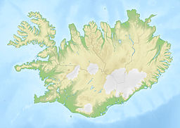
Hvítavatn (Icelandic pronunciation: [ˈkʰviːtaˌvahtn̥, ˈxʷiː-] ⓘ) is a small lake in the southern Highlands of Iceland. It is situated between Sídujökull and Skeiðarájökull, two of the southern arms of the big glacier Vatnajökull, and lies 15 km to the north of the infamous Skeiðará sander.
There are some lakes and rivers with the adjective hvíta (meaning white) in their name in Iceland. This comes from the origin of most of the freshwater on this island: the glaciers.

