Nowa Brzeźnica: Difference between revisions
Appearance
Content deleted Content added
Marcocapelle (talk | contribs) →References: Removed history categories, this is a geography article Tags: Mobile edit Mobile web edit Advanced mobile edit |
|||
| (8 intermediate revisions by 6 users not shown) | |||
| Line 1: | Line 1: | ||
{{Short description|Village in Łódź Voivodeship, Poland}} |
|||
{{Infobox settlement |
{{Infobox settlement |
||
| name = Nowa Brzeźnica |
| name = Nowa Brzeźnica |
||
| settlement_type = Village |
| settlement_type = Village |
||
| total_type = |
|||
| image_flag = |
|||
| image_shield = POL gmina Nowa Brzeźnica COA.svg |
| image_shield = POL gmina Nowa Brzeźnica COA.svg |
||
| image_skyline = POL Nowa Brzeźnica.jpg |
| image_skyline = POL Nowa Brzeźnica.jpg |
||
| Line 15: | Line 14: | ||
| subdivision_type3 = [[Gmina]] |
| subdivision_type3 = [[Gmina]] |
||
| subdivision_name3 = [[Gmina Nowa Brzeźnica|Nowa Brzeźnica]] |
| subdivision_name3 = [[Gmina Nowa Brzeźnica|Nowa Brzeźnica]] |
||
| coordinates = {{coord|51|4|N|19|10|E|region:PL|display=inline}} |
| coordinates = {{coord|51|4|N|19|10|E|region:PL|display=title,inline}} |
||
| pushpin_map = Poland |
| pushpin_map = Poland |
||
| pushpin_label_position = bottom |
| pushpin_label_position = bottom |
||
| elevation_m = |
| elevation_m = |
||
| population_total = 750 |
| population_total = 750 |
||
| timezone = [[Central European Time|CET]] |
|||
| website = }} |
|||
| utc_offset = +1 |
|||
| timezone_DST = [[Central European Summer Time|CEST]] |
|||
| utc_offset_DST = +2 |
|||
| registration_plate = EPJ |
|||
}} |
|||
| ⚫ | '''Nowa Brzeźnica''' {{IPAc-pl|'|n|o|w|a|-|b|ż|e|ź|'|n|i|c|a}} is a [[village]] in [[Pajęczno County]], [[Łódź Voivodeship]], in central Poland. It is the seat of the [[gmina]] (administrative district) called [[Gmina Nowa Brzeźnica]]. It lies approximately {{convert|15|km|mi|0}} south-east of [[Pajęczno]] and {{convert|83|km|mi|0|abbr=on}} south of the regional capital [[Łódź]].<ref name="TERYT">{{cite web |url=http://www.stat.gov.pl/broker/access/prefile/listPreFiles.jspa |title=Central Statistical Office (GUS) - TERYT (National Register of Territorial Land Apportionment Journal) |date=2008-06-01 |language=pl}}</ref> It is located in the historic [[Sieradz Land]]. |
||
It was a [[Royal city in Poland|royal town]], administratively located in the Radomsko County in the [[Sieradz Voivodeship (1339–1793)|Sieradz Voivodeship]] in the [[Greater Poland Province, Crown of the Kingdom of Poland|Greater Poland Province]] of the Kingdom of Poland.<ref>{{cite book|author=<!--Staff writer(s); no by-line.--> |title=Atlas historyczny Polski. Województwo sieradzkie i województwo łęczyckie w drugiej połowie XVI wieku. Część I. Mapy, plany|year=1998|language=pl|location=Warszawa|publisher=Instytut Historii [[Polish Academy of Sciences|Polskiej Akademii Nauk]]|page=4}}</ref> |
|||
| ⚫ | '''Nowa Brzeźnica''' {{IPAc-pl|'|n|o|w|a|-|b|ż|e|ź|'|n|i|c|a}} is a [[village]] |
||
The village has a population of ~750. |
|||
==References== |
==References== |
||
| Line 30: | Line 33: | ||
{{Gmina Nowa Brzeźnica}} |
{{Gmina Nowa Brzeźnica}} |
||
{{coord|51|4|N|19|10|E|region:PL_type:city|display=title}} |
|||
{{DEFAULTSORT:Nowa Brzeznica}} |
|||
[[Category:Villages in Pajęczno County]] |
[[Category:Villages in Pajęczno County]] |
||
[[Category: |
[[Category:Historic Jewish communities in Poland]] |
||
[[Category:Łódź Voivodeship (1919–1939)]] |
|||
[[Category:Shtetls]] |
|||
{{Pajęczno-geo-stub}} |
{{Pajęczno-geo-stub}} |
||
Latest revision as of 20:07, 20 August 2024
Nowa Brzeźnica | |
|---|---|
Village | |
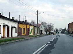
 Main street | |
| Coordinates: 51°4′N 19°10′E / 51.067°N 19.167°E | |
| Country | |
| Voivodeship | Łódź |
| County | Pajęczno |
| Gmina | Nowa Brzeźnica |
| Population | |
• Total | 750 |
| Time zone | UTC+1 (CET) |
| • Summer (DST) | UTC+2 (CEST) |
| Vehicle registration | EPJ |
Nowa Brzeźnica [ˈnɔva bʐɛʑˈnit͡sa] is a village in Pajęczno County, Łódź Voivodeship, in central Poland. It is the seat of the gmina (administrative district) called Gmina Nowa Brzeźnica. It lies approximately 15 kilometres (9 mi) south-east of Pajęczno and 83 km (52 mi) south of the regional capital Łódź.[1] It is located in the historic Sieradz Land.
It was a royal town, administratively located in the Radomsko County in the Sieradz Voivodeship in the Greater Poland Province of the Kingdom of Poland.[2]
References
[edit]- ^ "Central Statistical Office (GUS) - TERYT (National Register of Territorial Land Apportionment Journal)" (in Polish). 2008-06-01.
- ^ Atlas historyczny Polski. Województwo sieradzkie i województwo łęczyckie w drugiej połowie XVI wieku. Część I. Mapy, plany (in Polish). Warszawa: Instytut Historii Polskiej Akademii Nauk. 1998. p. 4.


