Romainville: Difference between revisions
clean up and general fixes using AWB |
RodRabelo7 (talk | contribs) |
||
| (32 intermediate revisions by 23 users not shown) | |||
| Line 1: | Line 1: | ||
{{About|the commune in Paris|the Nazi concentration camp|Fort de Romainville}} |
|||
{{Infobox French commune |
{{Infobox French commune |
||
|name = Romainville |
|name = Romainville |
||
|commune status = [[Communes of France|Commune]] |
|||
|image = Eglise de Romainville.JPG |
|||
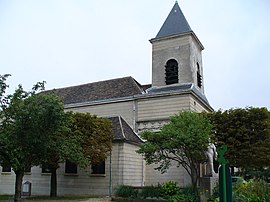
|caption = The church of [[Germanus of Auxerre|Saint-Germain-l'Auxerrois]], designed by [[Alexandre-Théodore Brongniart]] |
|||
|image coat of arms = Blason Romainville 93.svg |
|||
|map = Romainville_map.svg |
|map = Romainville_map.svg |
||
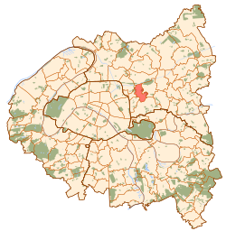
|map caption = [[Paris]] and inner ring departments |
|map caption = [[Paris]] and inner ring departments |
||
|coordinates = {{coord|48.884|2.435|format=dms|display=inline,title}} |
|||
|longitude =2.435 |
|||
|latitude =48.884 |
|||
|region = Île-de-France |
|||
|department = Seine-Saint-Denis |
|||
|arrondissement = Bobigny |
|arrondissement = Bobigny |
||
|canton = |
|canton = Bagnolet |
||
|INSEE = 93063 |
|INSEE = 93063 |
||
|postal code = 93230 |
|postal code = 93230 |
||
|mayor = François Dechy<ref>{{cite web|title=Répertoire national des élus: les maires|url=https://www.data.gouv.fr/fr/datasets/r/2876a346-d50c-4911-934e-19ee07b0e503|website=data.gouv.fr, Plateforme ouverte des données publiques françaises|date=2 December 2020|language=fr}}</ref> |
|||
|mayor = Corinne Valls |
|||
|term = |
|term = 2020–2026 |
||
|intercommunality = |
|intercommunality = [[Grand Paris]] |
||
|elevation m = 117 |
|elevation m = 117 |
||
|elevation min m = |
|elevation min m = |
||
|elevation max m = |
|elevation max m = |
||
|area km2 = 3.44 |
|area km2 = 3.44 |
||
|population = |
|population = {{France metadata Wikidata|population_total}} |
||
|population date = |
|population date = {{France metadata Wikidata|population_as_of}} |
||
|population footnotes = {{France metadata Wikidata|population_footnotes}} |
|||
}} |
}} |
||
'''Romainville''' is a [[Communes of France|commune]] in the eastern suburbs of [[Paris]], [[France]]. It is located {{convert|7.2|km|mi|abbr=on}} from the [[Kilometre Zero|center of Paris]]. |
'''Romainville''' ({{IPA|fr|ʁɔmɛ̃vil|-|Fr-Paris--Romainville.ogg}}) is a [[Communes of France|commune]] in the [[Seine-Saint-Denis]] department and in the eastern suburbs of [[Paris]], [[France]]. |
||
==Location== |
|||
It is located {{convert|7.2|km|mi|abbr=on}} from the [[Kilometre Zero|center of Paris]]. |
|||
==History== |
==History== |
||
| Line 33: | Line 39: | ||
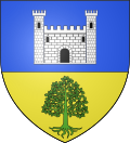
|text= The arms of Romainville are blazoned :<br />''Per fess azure and Or, a castle argent, open pierced and masoned sable, and an oak eradicated vert.'' |
|text= The arms of Romainville are blazoned :<br />''Per fess azure and Or, a castle argent, open pierced and masoned sable, and an oak eradicated vert.'' |
||
}} |
|||
==Population== |
|||
{{Historical populations |
|||
| align = none |
|||
| cols = 2 |
|||
| percentages = pagr |
|||
| source = EHESS<ref name=ehess>{{Cassini-Ehess|29514|Romainville}}</ref> and INSEE (1968-2017)<ref name=pophist>[https://www.insee.fr/fr/statistiques/4515315?geo=COM-93063#ancre-POP_T1 Population en historique depuis 1968], INSEE</ref> |
|||
| graph-pos = bottom |
|||
|1793 |1011 |
|||
|1800 |908 |
|||
|1806 |1035 |
|||
|1821 |839 |
|||
|1831 |1012 |
|||
|1836 |1222 |
|||
|1841 |1672 |
|||
|1846 |1597 |
|||
|1851 |1499 |
|||
|1856 |2083 |
|||
|1861 |4289 |
|||
|1866 |4907 |
|||
|1872 |2044 |
|||
|1876 |2025 |
|||
|1881 |1854 |
|||
|1886 |2106 |
|||
|1891 |2106 |
|||
|1896 |2408 |
|||
|1901 |2961 |
|||
|1906 |4472 |
|||
|1911 |5676 |
|||
|1921 |8087 |
|||
|1926 |12821 |
|||
|1931 |18449 |
|||
|1936 |18422 |
|||
|1946 |17022 |
|||
|1954 |19217 |
|||
|1962 |23494 |
|||
|1968 |24091 |
|||
|1975 |26260 |
|||
|1982 |25363 |
|||
|1990 |23563 |
|||
|1999 |23779 |
|||
|2007 |25563 |
|||
|2012 |25411 |
|||
|2017 |27567 |
|||
}} |
}} |
||
| Line 38: | Line 90: | ||
Romainville is served by no station of the Paris Métro, RER, or suburban rail network. The closest stations to Romainville are [[Mairie des Lilas (Paris Metro)|Mairie des Lilas]] station on [[Paris Métro Line 11]] and [[Bobigny - Pantin - Raymond Queneau (Paris Métro)|Bobigny - Pantin - Raymond Queneau]] station on [[Paris Métro Line 5]]. The former is located in the neighboring commune of [[Les Lilas]], {{convert|1.4|km|mi|abbr=on}} from the town center of Romainville, and the latter is located in the neighboring commune of [[Pantin]], {{convert|1.3|km|mi|abbr=on}} from the town center of Romainville. |
Romainville is served by no station of the Paris Métro, RER, or suburban rail network. The closest stations to Romainville are [[Mairie des Lilas (Paris Metro)|Mairie des Lilas]] station on [[Paris Métro Line 11]] and [[Bobigny - Pantin - Raymond Queneau (Paris Métro)|Bobigny - Pantin - Raymond Queneau]] station on [[Paris Métro Line 5]]. The former is located in the neighboring commune of [[Les Lilas]], {{convert|1.4|km|mi|abbr=on}} from the town center of Romainville, and the latter is located in the neighboring commune of [[Pantin]], {{convert|1.3|km|mi|abbr=on}} from the town center of Romainville. |
||
There are plans to extend Paris Métro Line 11 beyond its terminus at Mairie des Lilas station, reaching the town center of Romainville and beyond to [[Rosny-sous-Bois]]. |
There are plans to extend Paris Métro Line 11 beyond its terminus at Mairie des Lilas station, reaching the town center of Romainville and beyond to [[Rosny-sous-Bois]]. In 2024, a station on place Carnot will be opened with a connection to tram line 1. |
||
==Education== |
|||
{{Asof|2016}} there were 1,147 preschool (''maternelle'') students and 1,637 elementary students in Romainville communal primary schools, making a total of 2,782 students.<ref>"[http://www.ville-romainville.fr/petite-enfance-education/actualit%C3%A9s/rentr%C3%A9e-scolaire-2016-2017 Rentrée scolaire 2016-2017 ]." Romainville. Retrieved on September 12, 2016.</ref> |
|||
Primary schools:<ref>"[http://www.ville-romainville.fr/num%C3%A9ros-utiles Numéros utiles]." Romainville. Retrieved on September 12, 2016.</ref> |
|||
* Preschools: [[Marcel Cachin]], [[Danielle Casanova]], [[Charlie Chaplin]], [[Jean Charcot]], [[Yuri Gagarin|Youri Gagarine]], Véronique et Florestan |
|||
* Elementary schools: [[Henri Barbusse]], Marcel Cachin, Jean Charcot, Fraternité, [[Paul Langevin]], Gabriel-Péri, Paul Vaillant-Couturier, Maryse-Bastié. |
|||
Junior high schools: |
|||
* Collège [[Gustave Courbet]]<ref>[http://www.gustavecourbetromainville.ac-creteil.fr/ Home]. Collège Gustave Courbet. Retrieved on September 12, 2016.</ref> |
|||
* Collège Pierre-André Houël<ref>[http://www.clghouel-romainville.ac-creteil.fr/ Home]. Collège Pierre-André Houël. Retrieved on September 12, 2016.</ref> |
|||
[[Lycée Liberté]], a vocational high school, is in Romainville.<ref>[http://www.lyceeliberte.ac-creteil.fr/ Home].[[Lycée Liberté]]. Retrieved on September 12, 2016.</ref> |
|||
==International relations== |
==International relations== |
||
{{See also|List of twin towns and sister cities in France}} |
{{See also|List of twin towns and sister cities in France}} |
||
===Twin towns – Sister cities=== |
|||
Romainville is [[Twin towns and sister cities|twinned]] with: |
Romainville is [[Twin towns and sister cities|twinned]] with: |
||
*{{flagicon|ITA}} [[Casalecchio di Reno]], [[Italy]] |
|||
*{{flagicon|HUN}} [[Pápa]], [[Hungary]] |
*{{flagicon|HUN}} [[Pápa]], [[Hungary]] |
||
*{{flagicon|ENG}} [[South Benfleet|Benfleet]], [[England]] since 1962 |
|||
==See also== |
==See also== |
||
* [[Tour Hertzienne TDF de Romainville]] |
* [[Tour Hertzienne TDF de Romainville]] |
||
*[[Communes of the Seine-Saint-Denis department]] |
*[[Communes of the Seine-Saint-Denis department]] |
||
*[[Convoi des 31000]] |
|||
==References== |
==References== |
||
*[http://www.insee.fr/en/home/home_page.asp INSEE] |
|||
{{reflist}} |
{{reflist}} |
||
| Line 62: | Line 128: | ||
{{Paris Metropolitan Area}} |
{{Paris Metropolitan Area}} |
||
{{Seine-Saint-Denis communes}} |
{{Seine-Saint-Denis communes}} |
||
{{Authority control}} |
|||
[[Category:Communes of Seine-Saint-Denis]] |
[[Category:Communes of Seine-Saint-Denis]] |
||
Latest revision as of 07:42, 22 August 2024
Romainville | |
|---|---|
 The church of Saint-Germain-l'Auxerrois, designed by Alexandre-Théodore Brongniart | |
 Paris and inner ring departments | |
| Coordinates: 48°53′02″N 2°26′06″E / 48.884°N 2.435°E | |
| Country | France |
| Region | Île-de-France |
| Department | Seine-Saint-Denis |
| Arrondissement | Bobigny |
| Canton | Bagnolet |
| Intercommunality | Grand Paris |
| Government | |
| • Mayor (2020–2026) | François Dechy[1] |
Area 1 | 3.44 km2 (1.33 sq mi) |
| Population (2021)[2] | 33,266 |
| • Density | 9,700/km2 (25,000/sq mi) |
| Time zone | UTC+01:00 (CET) |
| • Summer (DST) | UTC+02:00 (CEST) |
| INSEE/Postal code | 93063 /93230 |
| Elevation | 117 m (384 ft) |
| 1 French Land Register data, which excludes lakes, ponds, glaciers > 1 km2 (0.386 sq mi or 247 acres) and river estuaries. | |
Romainville (French pronunciation: [ʁɔmɛ̃vil] ⓘ) is a commune in the Seine-Saint-Denis department and in the eastern suburbs of Paris, France.
Location
[edit]It is located 7.2 km (4.5 mi) from the center of Paris.
History
[edit]On 24 July 1867, a part of the territory of Romainville was detached and merged with a part of the territory of Pantin and a part of the territory of Bagnolet to create the commune of Les Lilas.
Heraldry
[edit] |
The arms of Romainville are blazoned : Per fess azure and Or, a castle argent, open pierced and masoned sable, and an oak eradicated vert.
|
Population
[edit]
|
| ||||||||||||||||||||||||||||||||||||||||||||||||||||||||||||||||||||||||||||||||||||||||||||||||||||||||||||||||||
| |||||||||||||||||||||||||||||||||||||||||||||||||||||||||||||||||||||||||||||||||||||||||||||||||||||||||||||||||||
| Source: EHESS[3] and INSEE (1968-2017)[4] | |||||||||||||||||||||||||||||||||||||||||||||||||||||||||||||||||||||||||||||||||||||||||||||||||||||||||||||||||||
Transport
[edit]Romainville is served by no station of the Paris Métro, RER, or suburban rail network. The closest stations to Romainville are Mairie des Lilas station on Paris Métro Line 11 and Bobigny - Pantin - Raymond Queneau station on Paris Métro Line 5. The former is located in the neighboring commune of Les Lilas, 1.4 km (0.87 mi) from the town center of Romainville, and the latter is located in the neighboring commune of Pantin, 1.3 km (0.81 mi) from the town center of Romainville.
There are plans to extend Paris Métro Line 11 beyond its terminus at Mairie des Lilas station, reaching the town center of Romainville and beyond to Rosny-sous-Bois. In 2024, a station on place Carnot will be opened with a connection to tram line 1.
Education
[edit]As of 2016[update] there were 1,147 preschool (maternelle) students and 1,637 elementary students in Romainville communal primary schools, making a total of 2,782 students.[5]
Primary schools:[6]
- Preschools: Marcel Cachin, Danielle Casanova, Charlie Chaplin, Jean Charcot, Youri Gagarine, Véronique et Florestan
- Elementary schools: Henri Barbusse, Marcel Cachin, Jean Charcot, Fraternité, Paul Langevin, Gabriel-Péri, Paul Vaillant-Couturier, Maryse-Bastié.
Junior high schools:
- Collège Gustave Courbet[7]
- Collège Pierre-André Houël[8]
Lycée Liberté, a vocational high school, is in Romainville.[9]
International relations
[edit]Romainville is twinned with:
See also
[edit]References
[edit]- ^ "Répertoire national des élus: les maires". data.gouv.fr, Plateforme ouverte des données publiques françaises (in French). 2 December 2020.
- ^ "Populations légales 2021" (in French). The National Institute of Statistics and Economic Studies. 28 December 2023.
- ^ Des villages de Cassini aux communes d'aujourd'hui: Commune data sheet Romainville, EHESS (in French).
- ^ Population en historique depuis 1968, INSEE
- ^ "Rentrée scolaire 2016-2017 ." Romainville. Retrieved on September 12, 2016.
- ^ "Numéros utiles." Romainville. Retrieved on September 12, 2016.
- ^ Home. Collège Gustave Courbet. Retrieved on September 12, 2016.
- ^ Home. Collège Pierre-André Houël. Retrieved on September 12, 2016.
- ^ Home.Lycée Liberté. Retrieved on September 12, 2016.
External links
[edit]- Official website (in French)


