Vauréal: Difference between revisions
WhisperToMe (talk | contribs) |
RodRabelo7 (talk | contribs) |
||
| (18 intermediate revisions by 9 users not shown) | |||
| Line 1: | Line 1: | ||
{{Infobox French commune |
{{Infobox French commune |
||
|name = Vauréal |
|name = Vauréal |
||
|commune status = [[Communes of France|Commune]] |
|||
|image = Vaureal-Hotel-de-ville.png |
|image = Vaureal-Hotel-de-ville.png |
||
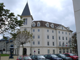
|caption = Town hall |
|caption = Town hall |
||
|image coat of arms = Blason de Vauréal.svg |
|image coat of arms = Blason de Vauréal.svg |
||
| |
|coordinates = {{coord|49.0353|2.0328|format=dms|display=inline,title}} |
||
|longitude = 2.0328 |
|||
|map size = 270px |
|map size = 270px |
||
|adjustable map = Vaureal_map.png |
|adjustable map = Vaureal_map.png |
||
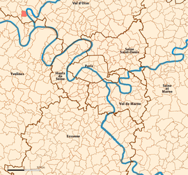
|map caption = Location (in red) within Paris inner and outer suburbs |
|map caption = Location (in red) within Paris inner and outer suburbs |
||
|region = Île-de-France |
|||
|department = Val-d'Oise |
|||
|arrondissement = Pontoise |
|arrondissement = Pontoise |
||
|canton = |
|canton = Vauréal |
||
|intercommunality = [[Cergy-Pontoise]] |
|intercommunality = [[Cergy-Pontoise]] |
||
|mayor = Raphaël Lanteri<ref>{{cite web|title=Répertoire national des élus: les maires|url=https://www.data.gouv.fr/fr/datasets/r/2876a346-d50c-4911-934e-19ee07b0e503|publisher=data.gouv.fr, Plateforme ouverte des données publiques françaises|date=30 November 2023|language=fr}}</ref> |
|||
|mayor = Bernard Morin |
|||
|term = |
|term = 2023–2026 |
||
|elevation min m = 22 |
|elevation min m = 22 |
||
|elevation max m = 122 |
|elevation max m = 122 |
||
|area km2 = 3.46 |
|area km2 = 3.46 |
||
|population = |
|population = {{France metadata Wikidata|population_total}} |
||
|population date = |
|population date = {{France metadata Wikidata|population_as_of}} |
||
|population footnotes = {{France metadata Wikidata|population_footnotes}} |
|||
|INSEE = 95637 |
|INSEE = 95637 |
||
|postal code = 95490 |
|postal code = 95490 |
||
}} |
}} |
||
'''Vauréal''' is a [[Communes of France|commune]] in the northwestern suburbs of [[Paris]], [[France]]. It is located {{convert|30.6|km|mi|abbr=on}} from the [[Kilometre Zero#France|center of Paris]], in the "[[new town#France|new town]]" of [[Cergy-Pontoise]], created in the 1960s. |
'''Vauréal''' ({{IPA|fr|voʁeal|-|Fr-Paris--Vauréal.ogg}}) is a [[Communes of France|commune]] in the northwestern suburbs of [[Paris]], [[France]]. It is located {{convert|30.6|km|mi|abbr=on}} from the [[Kilometre Zero#France|center of Paris]], in the "[[new town#France|new town]]" of [[Cergy-Pontoise]], created in the 1960s. |
||
| ⚫ | |||
==Population== |
|||
{{Historical populations |
|||
|source = INSEE<ref name=pophist>[https://www.insee.fr/fr/statistiques/4515315?geo=COM-95637#ancre-POP_T1 Population en historique depuis 1968], INSEE</ref> |
|||
|percentages = pagr |
|||
|align = none |
|||
|graph-pos = right |
|||
|1968 |607 |
|||
|1975 |662 |
|||
|1982 |866 |
|||
|1990 |12045 |
|||
|1999 |16206 |
|||
|2007 |15674 |
|||
|2012 |15868 |
|||
|2017 |16464 |
|||
}} |
|||
| ⚫ | |||
==Transportation== |
==Transportation== |
||
Vauréal is served by no station of the Paris Métro, RER, or suburban rail network. The closest station to Vauréal is [[Cergy – Le Haut (SNCF)|Cergy – Le Haut]] station on Paris [[RER A|RER line A]] and on the [[Transilien Paris – Saint-Lazare]] suburban rail line. This station is located in the neighboring commune of [[Cergy]], {{convert|2.2|km|mi|abbr=on}} from the town center of Vauréal. |
Vauréal is served by no station of the Paris Métro, RER, or suburban rail network. The closest station to Vauréal is [[Cergy – Le Haut (SNCF)|Cergy – Le Haut]] station on Paris [[RER A|RER line A]] and on the [[Transilien Paris – Saint-Lazare]] suburban rail line. This station is located in the neighboring commune of [[Cergy]], {{convert|2.2|km|mi|abbr=on}} from the town center of Vauréal. |
||
==Education== |
|||
Schools include: |
|||
*Eight primary schools<ref>"[http://www.vaureal.fr/etablissements-scolaires Les établissements scolaires à Vauréal]." Vauréal. Retrieved on September 6, 2016.</ref> |
|||
*Two junior high schools (''collèges''): La Bussie and Les Toupets<ref name=Secschools>"[http://www.vaureal.fr/node/405 Les établissements secondaires]." Vauréal. Retrieved on September 6, 2016.</ref> |
|||
*One senior high school, [[Lycée Camille Claudel (Vauréal)|Lycée Camille Claudel]]<ref name=Secschools/> |
|||
==See also== |
==See also== |
||
| Line 35: | Line 57: | ||
==References== |
==References== |
||
*[http://www.insee.fr/en/home/home_page.asp INSEE] |
|||
| ⚫ | |||
{{reflist}} |
{{reflist}} |
||
==External links== |
==External links== |
||
{{Commons category|Vauréal}} |
{{Commons category|Vauréal}} |
||
*[http://www.vaureal.fr Official website] {{ |
*[http://www.vaureal.fr Official website] {{in lang|fr}} |
||
*{{Search Mérimée|95637}} |
|||
*[http://www.culture.gouv.fr/public/mistral/merimee_fr?ACTION=CHERCHER&FIELD_98=INSEE&VALUE_98=95637 Mérimée database - Cultural heritage] {{Fr icon}} |
|||
| ⚫ | |||
*[http://www.iaurif.org/en/gis/fichescom/mos99/ficmos/mos95637.html Land use (IAURIF)] {{en icon}} |
|||
{{Cergy-Pontoise}} |
{{Cergy-Pontoise}} |
||
{{Paris Metropolitan Area}} |
{{Paris Metropolitan Area}} |
||
| Line 49: | Line 70: | ||
{{Authority control}} |
{{Authority control}} |
||
{{DEFAULTSORT:Vaureal}} |
{{DEFAULTSORT:Vaureal}} |
||
[[Category:Communes of Val-d'Oise]] |
[[Category:Communes of Val-d'Oise]] |
||
[[Category:Cergy-Pontoise]] |
[[Category:Cergy-Pontoise]] |
||
{{ValOise-geo-stub}} |
{{ValOise-geo-stub}} |
||
Latest revision as of 08:08, 22 August 2024
Vauréal | |
|---|---|
 Town hall | |
 Location (in red) within Paris inner and outer suburbs | |
| Coordinates: 49°02′07″N 2°01′58″E / 49.0353°N 2.0328°E | |
| Country | France |
| Region | Île-de-France |
| Department | Val-d'Oise |
| Arrondissement | Pontoise |
| Canton | Vauréal |
| Intercommunality | Cergy-Pontoise |
| Government | |
| • Mayor (2023–2026) | Raphaël Lanteri[1] |
Area 1 | 3.46 km2 (1.34 sq mi) |
| Population (2022)[2] | 16,079 |
| • Density | 4,600/km2 (12,000/sq mi) |
| Time zone | UTC+01:00 (CET) |
| • Summer (DST) | UTC+02:00 (CEST) |
| INSEE/Postal code | 95637 /95490 |
| Elevation | 22–122 m (72–400 ft) |
| 1 French Land Register data, which excludes lakes, ponds, glaciers > 1 km2 (0.386 sq mi or 247 acres) and river estuaries. | |
Vauréal (French pronunciation: [voʁeal] ⓘ) is a commune in the northwestern suburbs of Paris, France. It is located 30.6 km (19.0 mi) from the center of Paris, in the "new town" of Cergy-Pontoise, created in the 1960s.
French chocolate maker Henri Menier (1853–1913) had a château in Vauréal and named the 70-metre-high Vauréal Falls on Anticosti Island in Quebec province of Canada after the town.
Population
[edit]Graphs are unavailable due to technical issues. Updates on reimplementing the Graph extension, which will be known as the Chart extension, can be found on Phabricator and on MediaWiki.org. |
| Year | Pop. | ±% p.a. |
|---|---|---|
| 1968 | 607 | — |
| 1975 | 662 | +1.25% |
| 1982 | 866 | +3.91% |
| 1990 | 12,045 | +38.97% |
| 1999 | 16,206 | +3.35% |
| 2007 | 15,674 | −0.42% |
| 2012 | 15,868 | +0.25% |
| 2017 | 16,464 | +0.74% |
| Source: INSEE[3] | ||
Transportation
[edit]Vauréal is served by no station of the Paris Métro, RER, or suburban rail network. The closest station to Vauréal is Cergy – Le Haut station on Paris RER line A and on the Transilien Paris – Saint-Lazare suburban rail line. This station is located in the neighboring commune of Cergy, 2.2 km (1.4 mi) from the town center of Vauréal.
Education
[edit]Schools include:
- Eight primary schools[4]
- Two junior high schools (collèges): La Bussie and Les Toupets[5]
- One senior high school, Lycée Camille Claudel[5]
See also
[edit]References
[edit]- ^ "Répertoire national des élus: les maires" (in French). data.gouv.fr, Plateforme ouverte des données publiques françaises. 30 November 2023.
- ^ "Populations de référence 2022" (in French). The National Institute of Statistics and Economic Studies. 19 December 2024.
- ^ Population en historique depuis 1968, INSEE
- ^ "Les établissements scolaires à Vauréal." Vauréal. Retrieved on September 6, 2016.
- ^ a b "Les établissements secondaires." Vauréal. Retrieved on September 6, 2016.
External links
[edit]- Official website (in French)
- Base Mérimée: Search for heritage in the commune, Ministère français de la Culture. (in French)
- Association of Mayors of the Val d'Oise (in French)


