Graulhet: Difference between revisions
Appearance
Content deleted Content added
m Param fix |
RodRabelo7 (talk | contribs) |
||
| (41 intermediate revisions by 28 users not shown) | |||
| Line 1: | Line 1: | ||
{{French commune |
{{Infobox French commune |
||
|name = Graulhet |
|||
name=Graulhet<br>[[Image:Graulhet ruelle.jpg|270px]]<br><small>A lane in Graulhet</small>| |
|||
|commune status = [[Communes of France|Commune]] |
|||
région=[[Midi-Pyrénées]] | |
|||
|image = Graulhet ruelle.jpg |
|||
département=[[Tarn (department)|Tarn]]| |
|||
|caption = An alleyway near the chateau, in Graulhet |
|||
| ⚫ | |||
|image coat of arms = Blason ville fr Graulhet (Tarn).svg |
|||
canton=[[Canton of Graulhet|Graulhet]] (chief town)| |
|||
| ⚫ | |||
insee= 81105| |
|||
|canton = Graulhet |
|||
postal_code= 81300| |
|||
|INSEE = 81105 |
|||
gentilé=Graulhétois | |
|||
|postal code = 81300 |
|||
mayor= Jean Picarel |term=2001-2008| |
|||
|demonym = Graulhétois |
|||
intercomm= [[Communauté de Communes Tarn & Dadou]]| |
|||
|mayor = Blaise Aznar<ref>{{cite web|title=Répertoire national des élus: les maires|url=https://www.data.gouv.fr/fr/datasets/r/2876a346-d50c-4911-934e-19ee07b0e503|website=data.gouv.fr, Plateforme ouverte des données publiques françaises|date=2 December 2020|language=fr}}</ref> |
|||
longitude=1.98916666666667| |
|||
|term = 2020–2026 |
|||
latitude=43.7616666666667| |
|||
|intercommunality = [[Communauté d'agglomération Gaillac-Graulhet|CA Gaillac-Graulhet]] |
|||
elevation_m= 160| |
|||
|coordinates = {{coord|43.7617|1.9892|format=dms|display=inline,title}} |
|||
elevation_min_m= 126| |
|||
|elevation m = 160 |
|||
elevation_max_m= 373| |
|||
|elevation min m = 126 |
|||
hectares= 5675| |
|||
|elevation max m = 373 |
|||
area_km2= 56.75| |
|||
|area km2 = 56.75 |
|||
population= 12,656| |
|||
|population = {{France metadata Wikidata|population_total}} |
|||
date-population= 1999| |
|||
|population date = {{France metadata Wikidata|population_as_of}} |
|||
density_km2= 223| |
|||
|population footnotes = {{France metadata Wikidata|population_footnotes}} |
|||
date-density=1999}} |
|||
}} |
|||
'''Graulhet''' is a town in [[France]]. It is a centre of [[tanning]]. Leather was the main activity before industry went to China. Graulhet is crossed by the [[Dadou]] river; it is a typical village of the South of France, also called Midi. |
|||
'''Graulhet''' ({{IPA|fr|ɡʁojɛ}}) is a [[Communes of France|commune]] in the [[Tarn (department)|Tarn]] [[Departments of France|department]] in southern [[France]]. |
|||
| ⚫ | |||
It is a centre of [[Tanning (leather)|tanning]]. Leather was the main activity before this industry largely relocated to China. Graulhet is crossed by the river [[Dadou]]. Graulhet is also one of the last remaining places in the [[Southern France|Midi]] where [[Mesturets]] are made traditionally.<ref>{{cite book|first=Colin Duncan|last=Taylor|title=Menu from the Midi: A Gastronomic Journey through the South of France|year=2021|publisher=Matador |language=English| isbn= 978-1800464964}}</ref> |
|||
| ⚫ | |||
==Population== |
|||
[[ceb:Graulhet]] |
|||
{{Historical populations |
|||
[[fr:Graulhet]] |
|||
|source = INSEE<ref name=pophist>[https://www.insee.fr/fr/statistiques/4515315?geo=COM-81105#ancre-POP_T1 Population en historique depuis 1968], INSEE</ref> |
|||
[[it:Graulhet]] |
|||
|percentages = pagr |
|||
[[nl:Graulhet]] |
|||
|align = none |
|||
[[oc:Graulhet]] |
|||
|graph-pos = right |
|||
[[pl:Graulhet]] |
|||
|1968 |12073 |
|||
[[ro:Graulhet]] |
|||
|1975 |14097 |
|||
[[vo:Graulhet]] |
|||
|1982 |13543 |
|||
|1990 |13523 |
|||
|1999 |12663 |
|||
|2007 |12009 |
|||
|2012 |11890 |
|||
|2017 |12618 |
|||
}} |
|||
==See also== |
|||
*[[Communes of the Tarn department]] |
|||
==References== |
|||
{{reflist}} |
|||
{{commons category}} |
|||
{{Tarn communes}} |
|||
{{authority control}} |
|||
| ⚫ | |||
| ⚫ | |||
Latest revision as of 08:09, 22 August 2024
Graulhet | |
|---|---|
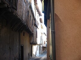
 An alleyway near the chateau, in Graulhet | |
| Coordinates: 43°45′42″N 1°59′21″E / 43.7617°N 1.9892°E | |
| Country | France |
| Region | Occitania |
| Department | Tarn |
| Arrondissement | Castres |
| Canton | Graulhet |
| Intercommunality | CA Gaillac-Graulhet |
| Government | |
| • Mayor (2020–2026) | Blaise Aznar[1] |
Area 1 | 56.75 km2 (21.91 sq mi) |
| Population (2021)[2] | 13,166 |
| • Density | 230/km2 (600/sq mi) |
| Demonym | Graulhétois |
| Time zone | UTC+01:00 (CET) |
| • Summer (DST) | UTC+02:00 (CEST) |
| INSEE/Postal code | 81105 /81300 |
| Elevation | 126–373 m (413–1,224 ft) (avg. 160 m or 520 ft) |
| 1 French Land Register data, which excludes lakes, ponds, glaciers > 1 km2 (0.386 sq mi or 247 acres) and river estuaries. | |
Graulhet (French pronunciation: [ɡʁojɛ]) is a commune in the Tarn department in southern France.
It is a centre of tanning. Leather was the main activity before this industry largely relocated to China. Graulhet is crossed by the river Dadou. Graulhet is also one of the last remaining places in the Midi where Mesturets are made traditionally.[3]
Population
[edit]Graphs are unavailable due to technical issues. There is more info on Phabricator and on MediaWiki.org. |
| Year | Pop. | ±% p.a. |
|---|---|---|
| 1968 | 12,073 | — |
| 1975 | 14,097 | +2.24% |
| 1982 | 13,543 | −0.57% |
| 1990 | 13,523 | −0.02% |
| 1999 | 12,663 | −0.73% |
| 2007 | 12,009 | −0.66% |
| 2012 | 11,890 | −0.20% |
| 2017 | 12,618 | +1.20% |
| Source: INSEE[4] | ||
See also
[edit]References
[edit]- ^ "Répertoire national des élus: les maires". data.gouv.fr, Plateforme ouverte des données publiques françaises (in French). 2 December 2020.
- ^ "Populations légales 2021" (in French). The National Institute of Statistics and Economic Studies. 28 December 2023.
- ^ Taylor, Colin Duncan (2021). Menu from the Midi: A Gastronomic Journey through the South of France. Matador. ISBN 978-1800464964.
- ^ Population en historique depuis 1968, INSEE
Wikimedia Commons has media related to Graulhet.


