Arnon (river): Difference between revisions
Appearance
Content deleted Content added
m lnk |
RodRabelo7 (talk | contribs) |
||
| (34 intermediate revisions by 18 users not shown) | |||
| Line 1: | Line 1: | ||
{{short description|River in central France}} |
|||
{{Infobox_river | river_name = Arnon |
|||
{{about|a river in France|the biblical river by the same name|Wadi Mujib}} |
|||
| image_name = |
|||
{{Infobox river |
|||
| caption = |
|||
| name = Arnon |
|||
| ⚫ | |||
| image = Charost Arnon.JPG |
|||
| mouth = [[Cher River|Cher]] |
|||
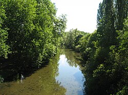
| image_caption = The Arnon at Chârost |
|||
| ⚫ | |||
| pushpin_map = France#France Centre |
|||
| length = 150 km |
|||
| ⚫ | |||
| elevation = |
|||
| mouth_location = [[Cher (river)|Cher]] |
|||
| discharge = |
|||
| mouth_coordinates = {{coord|47|13|1|N|2|0|42|E|format=dms|display=inline,title}} |
|||
| watershed = 2,274 km² |
|||
| progression = {{RCher}} |
|||
| subdivision_type1 = Country |
|||
| ⚫ | |||
| length = {{convert|150.5|km|abbr=on}} |
|||
| source1_elevation = |
|||
| discharge1_avg = |
|||
| basin_size = {{convert|2,274|km2|abbr=on}} |
|||
| tributaries_left = [[Théols]] |
|||
}} |
}} |
||
The '''Arnon''' is a |
The '''Arnon''' ({{IPA|fr|aʁnɔ̃}}) is a {{convert|150.5|km|abbr=on}} long river in central France. It is a left tributary of the river [[Cher (river)|Cher]].<ref name=sandre>{{Sandre|id=K6--0240|nom=Arnon}}</ref> Its source is near the village of [[Préveranges]], west of [[Montluçon]]. Its longest tributary is the [[Théols]].<ref name=sandre/> The Arnon flows generally north, through the following [[departments of France|departments]] and towns: |
||
* [[Allier]] |
* [[Allier]] |
||
| Line 17: | Line 25: | ||
The Arnon flows into the river Cher near [[Vierzon]]. |
The Arnon flows into the river Cher near [[Vierzon]]. |
||
==References== |
|||
{{Reflist}} |
|||
[[Category:Rivers of France]] |
[[Category:Rivers of France]] |
||
[[Category:Rivers of Auvergne-Rhône-Alpes]] |
|||
[[Category:Rivers of Centre-Val de Loire]] |
|||
[[Category:Rivers of Allier]] |
|||
[[Category:Rivers of Cher (department)]] |
|||
[[Category:Rivers of Indre]] |
|||
| ⚫ | |||
| ⚫ | |||
| ⚫ | |||
[[fr:Arnon]] |
|||
| ⚫ | |||
[[nn:Arnon]] |
|||
{{France-river-stub}} |
|||
Latest revision as of 11:53, 22 August 2024
| Arnon | |
|---|---|
 The Arnon at Chârost | |
| Location | |
| Country | France |
| Physical characteristics | |
| Source | |
| • location | Limousin |
| Mouth | |
• location | Cher |
• coordinates | 47°13′1″N 2°0′42″E / 47.21694°N 2.01167°E |
| Length | 150.5 km (93.5 mi) |
| Basin size | 2,274 km2 (878 sq mi) |
| Basin features | |
| Progression | Cher→ Loire→ Atlantic Ocean |
| Tributaries | |
| • left | Théols |
The Arnon (French pronunciation: [aʁnɔ̃]) is a 150.5 km (93.5 mi) long river in central France. It is a left tributary of the river Cher.[1] Its source is near the village of Préveranges, west of Montluçon. Its longest tributary is the Théols.[1] The Arnon flows generally north, through the following departments and towns:
The Arnon flows into the river Cher near Vierzon.
References
[edit]


