Boissettes: Difference between revisions
Appearance
Content deleted Content added
m rm dead external map link |
RodRabelo7 (talk | contribs) |
||
| (4 intermediate revisions by 2 users not shown) | |||
| Line 9: | Line 9: | ||
|arrondissement = Melun |
|arrondissement = Melun |
||
|canton = Savigny-le-Temple |
|canton = Savigny-le-Temple |
||
|mayor = Thierry Segura<ref>{{cite web|title=Répertoire national des élus: les maires|url=https://www.data.gouv.fr/fr/datasets/r/2876a346-d50c-4911-934e-19ee07b0e503|publisher=data.gouv.fr, Plateforme ouverte des données publiques françaises|date=13 September 2022|language=fr}}</ref> |
|||
|mayor = Jean-Pierre Legrand |
|||
|term = |
|term = 2020–2026 |
||
|intercommunality = [[Communauté d'agglomération Melun Val de Seine|CA Melun Val de Seine]] |
|intercommunality = [[Communauté d'agglomération Melun Val de Seine|CA Melun Val de Seine]] |
||
|elevation min m = 37 |
|elevation min m = 37 |
||
| Line 20: | Line 20: | ||
}} |
}} |
||
'''Boissettes''' is a [[Communes of France|commune]] in the [[Seine-et-Marne]] [[Departments of France|department]] in the [[ |
'''Boissettes''' ({{IPA|fr|bwasɛt|-|LL-Q150 (fra)-Persepha-Boissettes.wav}}) is a [[Communes of France|commune]] in the [[Seine-et-Marne]] [[Departments of France|department]] in the [[Île-de-France]] [[Regions of France|region]] in north-central [[France]]. |
||
==Demographics== |
==Demographics== |
||
| Line 34: | Line 34: | ||
{{commons category|Boissettes}} |
{{commons category|Boissettes}} |
||
*[https://web.archive.org/web/20070929122757/http://www.iaurif.org/en/gis/fichescom/mos99/ficmos/mos77038.html 1999 Land Use, from IAURIF (Institute for Urban Planning and Development of the Paris-Île-de-France région)] |
*[https://web.archive.org/web/20070929122757/http://www.iaurif.org/en/gis/fichescom/mos99/ficmos/mos77038.html 1999 Land Use, from IAURIF (Institute for Urban Planning and Development of the Paris-Île-de-France région)] |
||
* {{Search Mérimée|77038}} |
|||
*[http://www.culture.gouv.fr/public/mistral/merimee_fr?ACTION=CHERCHER&FIELD_98=INSEE&VALUE_98=77038 French Ministry of Culture list for Boissettes] {{in lang|fr}} |
|||
{{Seine-et-Marne communes}} |
{{Seine-et-Marne communes}} |
||
Latest revision as of 12:13, 22 August 2024
Boissettes | |
|---|---|
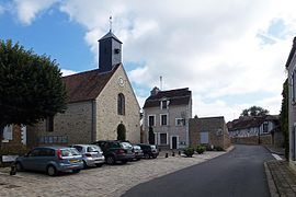
 The church in Boissettes | |
| Coordinates: 48°31′17″N 2°36′38″E / 48.5214°N 2.6106°E | |
| Country | France |
| Region | Île-de-France |
| Department | Seine-et-Marne |
| Arrondissement | Melun |
| Canton | Savigny-le-Temple |
| Intercommunality | CA Melun Val de Seine |
| Government | |
| • Mayor (2020–2026) | Thierry Segura[1] |
Area 1 | 1.54 km2 (0.59 sq mi) |
| Population (2022)[2] | 432 |
| • Density | 280/km2 (730/sq mi) |
| Time zone | UTC+01:00 (CET) |
| • Summer (DST) | UTC+02:00 (CEST) |
| INSEE/Postal code | 77038 /77350 |
| Elevation | 37–78 m (121–256 ft) |
| 1 French Land Register data, which excludes lakes, ponds, glaciers > 1 km2 (0.386 sq mi or 247 acres) and river estuaries. | |
Boissettes (French pronunciation: [bwasɛt] ⓘ) is a commune in the Seine-et-Marne department in the Île-de-France region in north-central France.
Demographics
[edit]The inhabitants are called Boissettais.
See also
[edit]References
[edit]- ^ "Répertoire national des élus: les maires" (in French). data.gouv.fr, Plateforme ouverte des données publiques françaises. 13 September 2022.
- ^ "Populations de référence 2022" (in French). The National Institute of Statistics and Economic Studies. 19 December 2024.
External links
[edit]Wikimedia Commons has media related to Boissettes.
- 1999 Land Use, from IAURIF (Institute for Urban Planning and Development of the Paris-Île-de-France région)
- Base Mérimée: Search for heritage in the commune, Ministère français de la Culture. (in French)


