San Sebastián, Lempira: Difference between revisions
No edit summary Tags: Visual edit Mobile edit Mobile web edit Newcomer task Newcomer task: copyedit |
layout fix, fix markup, don't link titles |
||
| (One intermediate revision by one other user not shown) | |||
| Line 1: | Line 1: | ||
{{Other uses|San Sebastian (disambiguation)}} |
|||
{{EngvarB|date=July 2016}} |
{{EngvarB|date=July 2016}} |
||
{{Use dmy dates|date=July 2016}} |
{{Use dmy dates|date=July 2016}} |
||
{{Tone|date=April 2019}}{{Infobox settlement |
{{Tone|date=April 2019}} |
||
{{Infobox settlement |
|||
|official_name = San Sebastián |
|official_name = San Sebastián |
||
|native_name = Colosuca <!-- for cities whose native name is not in English --> |
|native_name = Colosuca <!-- for cities whose native name is not in English --> |
||
| Line 75: | Line 75: | ||
|footnotes = |
|footnotes = |
||
}} |
}} |
||
| ⚫ | |||
''' |
'''San Sebastián''' is a [[municipality]] in the Honduran [[Departments of Honduras|department]] of [[Lempira department|Lempira]]. |
||
It is one of the most isolated [[municipalities]] in [[Lempira Department|Lempira]] and is located 13 km away from [[San Manuel Colohete]]. |
It is one of the most isolated [[municipalities]] in [[Lempira Department|Lempira]] and is located 13 km away from [[San Manuel Colohete]]. |
||
| Line 86: | Line 86: | ||
== Geography == |
== Geography == |
||
{{Confusing section|date=April 2019}} |
{{Confusing section|date=April 2019}} |
||
The municipality capital is up on a big mountain, surrounded by many pine trees and some oak trees. The mountains are very high and steep. In some of these mountains the vegetation changes to bushes and undergrowth. The origin of the rocks and soil all around is |
The municipality capital is up on a big mountain, surrounded by many pine trees and some oak trees. The mountains are very high and steep. In some of these mountains the vegetation changes to bushes and undergrowth. The origin of the rocks and soil all around is volcanic.{{Citation needed|date=January 2023}} |
||
== Boundaries == |
== Boundaries == |
||
| Line 100: | Line 100: | ||
== Population == |
== Population == |
||
* |
*Population: For the year 2001 this municipality had 8,026 people, and in 2013 the municipality had 10,453 people.<ref>{{Cite web |title=San Sebastián (Municipality, Honduras) - Population Statistics, Charts, Map and Location |url=https://citypopulation.de/en/honduras/admin/lempira/1321__san_sebasti%C3%A1n/ |access-date=2022-09-02 |website=citypopulation.de}}</ref><ref>{{Cite web |title=INE – Instituto Nacional de Estadística Honduras |url=https://www.ine.gob.hn/V3/ |access-date=2022-09-02 |language=es-ES}}</ref> |
||
* |
*Villages: 7 |
||
* |
*Settlements: 108 |
||
===Demographics=== |
===Demographics=== |
||
| Line 112: | Line 112: | ||
There are two rivers that must be crossed. One can only be crossed during the [[dry season]]. The other can be crossed via a bridge. The [[Congolon Mountain]] can be seen to the south and some other mountains in [[Ocotepeque]] to the north. The old church also gives a good reason to visit, if the traveler enjoys ancient colonial buildings. This municipality is in the [[Colosuca path]], this is organized by the [[National Institute of Tourism and Hospitality Management|national institute of tourism]] and some Mayor's offices of several municipalities. The object of this is to show the [[Indian legacy]]. |
There are two rivers that must be crossed. One can only be crossed during the [[dry season]]. The other can be crossed via a bridge. The [[Congolon Mountain]] can be seen to the south and some other mountains in [[Ocotepeque]] to the north. The old church also gives a good reason to visit, if the traveler enjoys ancient colonial buildings. This municipality is in the [[Colosuca path]], this is organized by the [[National Institute of Tourism and Hospitality Management|national institute of tourism]] and some Mayor's offices of several municipalities. The object of this is to show the [[Indian legacy]]. |
||
* |
*Local Holidays: "[[San Sebastián]]" day on 20 January. |
||
==References== |
==References== |
||
| Line 119: | Line 119: | ||
==External links== |
==External links== |
||
{{commons}} |
{{commons}} |
||
| ⚫ | |||
{{Lempira Department}} |
{{Lempira Department}} |
||
Latest revision as of 15:02, 22 August 2024
This article's tone or style may not reflect the encyclopedic tone used on Wikipedia. (April 2019) |
San Sebastián
Colosuca | |
|---|---|
Municipality | |
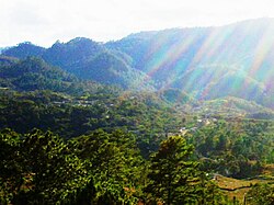
 Panoramic View San Sebastián | |
| Coordinates: 14°15′N 88°30′W / 14.250°N 88.500°W | |
| Country | Honduras |
| Department | Lempira |
| Municipality since | 7 March 1896 |
| Area | |
• Total | 227 km2 (88 sq mi) |
| Population (2014) | |
• Total | 10,857 |
| • Density | 48/km2 (120/sq mi) |

San Sebastián is a municipality in the Honduran department of Lempira.
It is one of the most isolated municipalities in Lempira and is located 13 km away from San Manuel Colohete.
History
[edit]In the 1887 census, San Sebastián appeared as Colosuca village, of Gracias. It became a municipality on 7 March 1896. The name "Colosuca" means "Beautiful Place"[whose translation?].

Geography
[edit]This section may be confusing or unclear to readers. (April 2019) |
The municipality capital is up on a big mountain, surrounded by many pine trees and some oak trees. The mountains are very high and steep. In some of these mountains the vegetation changes to bushes and undergrowth. The origin of the rocks and soil all around is volcanic.[citation needed]
Boundaries
[edit]Its boundaries are:
- North: San Manuel Colohete municipality and Ocotepeque department.
- South: Tomalá and San Andrés municipalities.
- East: La Campa and San Manuel Colohete municipalities.
- West: Guarita, Cololaca and San Marcos de Caiquin municipalities.
- Area: 227 km2
Resources
[edit]The coffee harvest provides jobs for the locals and people from other places, as it's the main economic activity of the region. The second most important activity is raising cattle. [citation needed]The commerce of groceries with Gracias is a very profitable activity. The corn and bean crops are primarily for local consumption. In 2007, a sewage system was installed, using water from perforated wells. San Sebastián is connected to the electricity network and has mobile communications coverage. As for the transportation services, only one bus is available, and it stays in the municipality's capital and travels back from Gracias in the afternoon.
Population
[edit]- Population: For the year 2001 this municipality had 8,026 people, and in 2013 the municipality had 10,453 people.[1][2]
- Villages: 7
- Settlements: 108
Demographics
[edit]At the time of the 2013 Honduras census, San Sebastián municipality had a population of 10,453. Of these, 89.83% were Indigenous (89.76% Lenca), 10.00% Mestizo and 0.17% Black or Afro-Honduran.[3]
Tourism
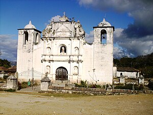
[edit]Once Colohete is passed the road becomes narrower and steeper and therefore more dangerous. 4-wheel drive vehicles are needed when visiting this municipality. There are two rivers that must be crossed. One can only be crossed during the dry season. The other can be crossed via a bridge. The Congolon Mountain can be seen to the south and some other mountains in Ocotepeque to the north. The old church also gives a good reason to visit, if the traveler enjoys ancient colonial buildings. This municipality is in the Colosuca path, this is organized by the national institute of tourism and some Mayor's offices of several municipalities. The object of this is to show the Indian legacy.
- Local Holidays: "San Sebastián" day on 20 January.
References
[edit]- ^ "San Sebastián (Municipality, Honduras) - Population Statistics, Charts, Map and Location". citypopulation.de. Retrieved 2 September 2022.
- ^ "INE – Instituto Nacional de Estadística Honduras" (in European Spanish). Retrieved 2 September 2022.
- ^ Instituto Nacional de Estadística (INE), bases de datos en línea


