Rošnja: Difference between revisions
Appearance
Content deleted Content added
GreenC bot (talk | contribs) m 1 archive template merged to {{webarchive}} (WAM) |
Tom.Reding (talk | contribs) |
||
| (3 intermediate revisions by 2 users not shown) | |||
| Line 31: | Line 31: | ||
|pushpin_label_position = left |
|pushpin_label_position = left |
||
|pushpin_map_caption = Location in Slovenia |
|pushpin_map_caption = Location in Slovenia |
||
|coordinates_display = inline,title |
|||
|coordinates_region = SI |
|||
|subdivision_type = Country |
|subdivision_type = Country |
||
|subdivision_name = [[Image:Flag of Slovenia.svg|25px]] [[Slovenia]] |
|subdivision_name = [[Image:Flag of Slovenia.svg|25px]] [[Slovenia]] |
||
| Line 40: | Line 38: | ||
|subdivision_name2 = [[Drava Statistical Region|Drava]] |
|subdivision_name2 = [[Drava Statistical Region|Drava]] |
||
|subdivision_type3 = [[Municipalities of Slovenia|Municipality]] |
|subdivision_type3 = [[Municipalities of Slovenia|Municipality]] |
||
|subdivision_name3 = [[Starše]] |
|subdivision_name3 = [[Municipality of Starše|Starše]] |
||
|subdivision_type4 = |
|subdivision_type4 = |
||
|subdivision_name4 = |
|subdivision_name4 = |
||
| Line 96: | Line 94: | ||
|timezone_DST = |
|timezone_DST = |
||
|utc_offset_DST = |
|utc_offset_DST = |
||
|coordinates = {{coord|46|28|35.91|N|15|44|56.28|E|region:SI|display=inline,title}} |
|||
|latd=46|latm=28|lats=35.91 |latNS=N |
|||
|longd=15|longm=44|longs=56.28 |longEW=E |
|||
|elevation_footnotes = |
|elevation_footnotes = |
||
|elevation_m = 240 |
|elevation_m = 240 |
||
| Line 111: | Line 108: | ||
|footnotes = <ref>[http://www.stat.si/eng/index.asp Statistical Office of the Republic of Slovenia] {{webarchive |url=https://web.archive.org/web/20081118142042/http://www.stat.si/eng/index.asp |date=November 18, 2008 }}</ref> |
|footnotes = <ref>[http://www.stat.si/eng/index.asp Statistical Office of the Republic of Slovenia] {{webarchive |url=https://web.archive.org/web/20081118142042/http://www.stat.si/eng/index.asp |date=November 18, 2008 }}</ref> |
||
}} |
}} |
||
'''Rošnja''' ({{IPA |
'''Rošnja''' ({{IPA|sl|ˈɾɔːʃnja|pron}} or {{IPA|sl|ˈɾoːʃnja|}}) is a [[village]] in the [[Municipality of Starše]] in northeastern [[Slovenia]]. It lies on the right bank of the [[Drava|Drava River]] on the local road from Starše towards [[Miklavž na Dravskem Polju]]. The area is part of the traditional region of [[Lower Styria|Styria]]. The entire municipality is now included in the [[Drava Statistical Region]].<ref>[http://www.starse.si/ Starše municipal site]</ref> |
||
==References== |
==References== |
||
| Line 117: | Line 114: | ||
==External links== |
==External links== |
||
*[ |
*[https://www.geopedia.world/#T12_L362_F2473:5757_x1752980.7035916457_y5856227.483321836_s15_b2345 Rošnja on Geopedia] |
||
{{Starše}} |
{{Starše}} |
||
Latest revision as of 15:57, 23 August 2024
Rošnja | |
|---|---|
| Coordinates: 46°28′35.91″N 15°44′56.28″E / 46.4766417°N 15.7489667°E | |
| Country | |
| Traditional region | Styria |
| Statistical region | Drava |
| Municipality | Starše |
| Area | |
• Total | 2.56 km2 (0.99 sq mi) |
| Elevation | 240 m (790 ft) |
| Population (2002) | |
• Total | 399 |
| [1] | |
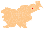
Rošnja (pronounced [ˈɾɔːʃnja] or [ˈɾoːʃnja]) is a village in the Municipality of Starše in northeastern Slovenia. It lies on the right bank of the Drava River on the local road from Starše towards Miklavž na Dravskem Polju. The area is part of the traditional region of Styria. The entire municipality is now included in the Drava Statistical Region.[2]
References
[edit]- ^ Statistical Office of the Republic of Slovenia Archived November 18, 2008, at the Wayback Machine
- ^ Starše municipal site
External links
[edit]


