Bertizarana: Difference between revisions
Appearance
Content deleted Content added
m robot Adding: fr:Bertizarana |
No edit summary |
||
| (32 intermediate revisions by 21 users not shown) | |||
| Line 1: | Line 1: | ||
{{Infobox settlement |
|||
| ⚫ | |||
| official_name = Bertizarana |
|||
| settlement_type = |
|||
| image_skyline = File:Erreparatzeako zubia.jpg |
|||
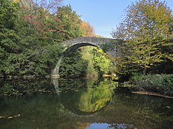
| image_caption = Bridge in Oieregi, Bertizarana |
|||
| image_flag = |
|||
| image_shield = [[File:Escudo de Bértiz-Arana.svg|70px]] |
|||
| nickname = |
|||
| image_map = |
|||
| mapsize = |
|||
| map_alt = |
|||
| map_caption = |
|||
| pushpin_map = Spain Navarre#Spain |
|||
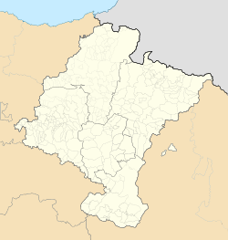
| pushpin_map_caption = Location of Bertizarana within Navarre##Location of Bertizarana within Spain |
|||
| pushpin_label_position = top |
|||
| pushpin_map_alt = |
|||
| coordinates = {{coord|43.1758|N|1.62778|W|source:kolossus-ruwiki|display=inline}} |
|||
| subdivision_type = [[List of sovereign states|Country]] |
|||
| subdivision_name = [[Spain]] |
|||
| subdivision_type1 = [[Autonomous communities of Spain|Autonomous community]] |
|||
| subdivision_name1 = [[Navarra]] |
|||
| subdivision_type2 = [[Provinces of Spain|Province]] |
|||
| subdivision_name2 = |
|||
| subdivision_type3 = |
|||
| subdivision_name3 = |
|||
| leader_title = |
|||
| leader_name = |
|||
| area_total_km2 = 39.56 |
|||
| area_land_km2 = |
|||
| area_water_km2 = |
|||
| elevation_m = 136 |
|||
| population_as_of = {{Spain metadata Wikidata|population_as_of}} |
|||
| population_footnotes = {{Spain metadata Wikidata|population_footnotes}} |
|||
| population_total = {{Spain metadata Wikidata|population_total}} |
|||
| population_density_km2 = auto |
|||
| population_demonym = |
|||
| timezone = [[Central European Time|CET]] |
|||
| utc_offset = +1 |
|||
| timezone_DST = [[Central European Summer Time|CEST]] |
|||
| utc_offset_DST = +2 |
|||
| website = |
|||
| footnotes = |
|||
}} |
|||
| ⚫ | |||
== |
==References== |
||
{{reflist}} |
|||
| ⚫ | |||
==External links== |
|||
| ⚫ | |||
| ⚫ | |||
{{Municipalities in Navarre}} |
|||
| ⚫ | |||
{{authority control}} |
|||
| ⚫ | |||
[[eu:Bertizarana]] |
|||
| ⚫ | |||
[[fr:Bertizarana]] |
|||
[[it:Bertizarana]] |
|||
[[pt:Bertizarana]] |
|||
Latest revision as of 04:49, 24 August 2024
Bertizarana | |
|---|---|
 Bridge in Oieregi, Bertizarana | |
| Coordinates: 43°10′33″N 1°37′40″W / 43.1758°N 1.62778°W | |
| Country | Spain |
| Autonomous community | Navarra |
| Area | |
• Total | 39.56 km2 (15.27 sq mi) |
| Elevation | 136 m (446 ft) |
| Population (2018)[1] | |
• Total | 607 |
| • Density | 15/km2 (40/sq mi) |
| Time zone | UTC+1 (CET) |
| • Summer (DST) | UTC+2 (CEST) |
Bertizarana is a town and municipality located in the province and autonomous community of Navarre, northern Spain.
References
[edit]- ^ Municipal Register of Spain 2018. National Statistics Institute.


