Montgellafrey: Difference between revisions
Appearance
Content deleted Content added
merger |
RodRabelo7 (talk | contribs) |
||
| (6 intermediate revisions by 4 users not shown) | |||
| Line 6: | Line 6: | ||
|arrondissement = Saint-Jean-de-Maurienne |
|arrondissement = Saint-Jean-de-Maurienne |
||
|canton = Saint-Jean-de-Maurienne |
|canton = Saint-Jean-de-Maurienne |
||
|commune = Saint-François-Longchamp |
|||
|INSEE = 73167 |
|INSEE = 73167 |
||
|postal code = 73130 |
|postal code = 73130 |
||
| Line 12: | Line 13: | ||
|elevation max m = 2610 |
|elevation max m = 2610 |
||
|area km2 = 19.36 |
|area km2 = 19.36 |
||
|population = |
|population = 87 |
||
|population date = |
|population date = 2019 |
||
|population footnotes = <ref name=pop2019>[https://www.insee.fr/fr/statistiques/fichier/6011070/ensemble.pdf Téléchargement du fichier d'ensemble des populations légales en 2019], [[Institut national de la statistique et des études économiques|INSEE]]</ref> |
|||
|website = [http://www.montgellafrey.fr/ www.montgellafrey.fr] |
|website = [http://www.montgellafrey.fr/ www.montgellafrey.fr] |
||
}} |
}} |
||
'''Montgellafrey''' is a former [[Communes of France|commune]] in the [[Savoie]] [[Departments of France|department]] in the [[Auvergne-Rhône-Alpes]] [[Regions of France|region]] in south-eastern [[France]]. On 1 January 2017, it was merged into the commune [[Saint-François-Longchamp]].<ref>[https://www.legifrance.gouv.fr/eli/arrete/2016/12/19/INTB1602354A/jo/texte Arrêté préfectoral] 19 December 2016 {{fr}}</ref> |
'''Montgellafrey''' ({{IPA|fr|mɔ̃ʒɛlafʁɛ}}) is a former [[Communes of France|commune]] in the [[Savoie]] [[Departments of France|department]] in the [[Auvergne-Rhône-Alpes]] [[Regions of France|region]] in south-eastern [[France]]. On 1 January 2017, it was merged into the commune [[Saint-François-Longchamp]].<ref>[https://www.legifrance.gouv.fr/eli/arrete/2016/12/19/INTB1602354A/jo/texte Arrêté préfectoral] 19 December 2016 {{in lang|fr}}</ref> |
||
==See also== |
==See also== |
||
| Line 26: | Line 28: | ||
==External links== |
==External links== |
||
{{commons category}} |
|||
{{commonscat}} |
|||
*[http://www.montgellafrey.fr/ Official site] |
*[http://www.montgellafrey.fr/ Official site] |
||
{{authority control}} |
|||
[[Category:Former communes of Savoie]] |
[[Category:Former communes of Savoie]] |
||
{{Savoie-geo-stub}} |
{{Savoie-geo-stub}} |
||
Latest revision as of 00:56, 25 August 2024
Montgellafrey | |
|---|---|
Part of Saint-François-Longchamp | |
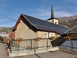
 The church of Saint-Théodule, in Montgellafrey | |
| Coordinates: 45°23′34″N 6°19′10″E / 45.3928°N 6.3194°E | |
| Country | France |
| Region | Auvergne-Rhône-Alpes |
| Department | Savoie |
| Arrondissement | Saint-Jean-de-Maurienne |
| Canton | Saint-Jean-de-Maurienne |
| Commune | Saint-François-Longchamp |
Area 1 | 19.36 km2 (7.47 sq mi) |
| Population (2019)[1] | 87 |
| • Density | 4.5/km2 (12/sq mi) |
| Time zone | UTC+01:00 (CET) |
| • Summer (DST) | UTC+02:00 (CEST) |
| Postal code | 73130 |
| Elevation | 821–2,610 m (2,694–8,563 ft) |
| Website | www.montgellafrey.fr |
| 1 French Land Register data, which excludes lakes, ponds, glaciers > 1 km2 (0.386 sq mi or 247 acres) and river estuaries. | |
Montgellafrey (French pronunciation: [mɔ̃ʒɛlafʁɛ]) is a former commune in the Savoie department in the Auvergne-Rhône-Alpes region in south-eastern France. On 1 January 2017, it was merged into the commune Saint-François-Longchamp.[2]
See also
[edit]References
[edit]- ^ Téléchargement du fichier d'ensemble des populations légales en 2019, INSEE
- ^ Arrêté préfectoral 19 December 2016 (in French)
External links
[edit]Wikimedia Commons has media related to Montgellafrey.


