Pietracatella: Difference between revisions
Appearance
Content deleted Content added
m robot Adding: ru:Пьетракателла |
Added Template:Expand Italian |
||
| (19 intermediate revisions by 13 users not shown) | |||
| Line 1: | Line 1: | ||
{{Infobox Italian comune |
{{Expand Italian|date=August 2024|topic=geo}}{{Infobox Italian comune |
||
| name = Pietracatella |
| name = Pietracatella |
||
| official_name = Comune di Pietracatella |
| official_name = Comune di Pietracatella |
||
| native_name = |
| native_name = |
||
| image_skyline = |
| image_skyline = San_Giacomo_in_prospettiva.jpg |
||
| imagesize = |
| imagesize = |
||
| image_alt = |
| image_alt = |
||
| image_caption = |
| image_caption = Church of St. James. |
||
| image_shield = |
| image_shield = |
||
| shield_alt = |
| shield_alt = |
||
| Line 14: | Line 14: | ||
| pushpin_label_position = |
| pushpin_label_position = |
||
| pushpin_map_alt = |
| pushpin_map_alt = |
||
| coordinates = {{coord|41|35|N|14|52|E|type:city(1,543)_region:IT|display=inline,title}} |
|||
| latd = 41 |latm = 35 |lats = |latNS = N |
|||
| longd = 14 |longm = 52 |longs = |longEW = E |
|||
| coordinates_type = type:city(1,543)_region:IT |
|||
| coordinates_display = title |
|||
| coordinates_footnotes = |
| coordinates_footnotes = |
||
| region = [[Molise]] |
| region = [[Molise]] |
||
| province = [[Province of Campobasso]] (CB) |
| province = [[Province of Campobasso|Campobasso]] (CB) |
||
| frazioni = |
| frazioni = |
||
| mayor_party = |
| mayor_party = |
||
| mayor = |
| mayor = Luciano Pasquale |
||
| area_footnotes = |
| area_footnotes = |
||
| area_total_km2 = 50.0 |
| area_total_km2 = 50.0 |
||
| population_footnotes = .<ref name="istat">All demographics and other statistics: Italian statistical institute [[National Institute of Statistics (Italy)|Istat]].</ref> |
|||
| population_footnotes = |
|||
| population_total = |
| population_total = 1309 |
||
| population_as_of = |
| population_as_of = 30 November 2017 |
||
| pop_density_footnotes = |
| pop_density_footnotes = |
||
| population_demonym = |
| population_demonym = Pietracatellesi |
||
| elevation_footnotes = |
| elevation_footnotes = |
||
| elevation_m = |
| elevation_m = 721 |
||
| twin1 = |
| twin1 = |
||
| twin1_country = |
| twin1_country = |
||
| Line 39: | Line 36: | ||
| postal_code = 86040 |
| postal_code = 86040 |
||
| area_code = 0874 |
| area_code = 0874 |
||
| website = |
| website = {{official website|www.comune.pietracatella.cb.it}} |
||
| footnotes = |
| footnotes = |
||
}} |
}} |
||
'''Pietracatella''' is a ''[[comune]]'' (municipality) in the [[Province of Campobasso]] in the [[Italy|Italian]] region [[Molise]], located about 15 |
'''Pietracatella''' is a ''[[comune]]'' (municipality) in the [[Province of Campobasso]] in the [[Italy|Italian]] region [[Molise]], located about {{convert|15|km|mi|0}} east of [[Campobasso]]. |
||
Pietracatella borders the following municipalities: [[Gambatesa]], [[Jelsi]], [[Macchia Valfortore]], [[Monacilioni]], [[Riccia, Italy|Riccia]], [[Toro, Italy|Toro]]. |
Pietracatella borders the following municipalities: [[Gambatesa]], [[Jelsi]], [[Macchia Valfortore]], [[Monacilioni]], [[Riccia, Italy|Riccia]], [[Toro, Italy|Toro]]. |
||
==References== |
|||
{{reflist}} |
|||
{{clear}} |
|||
== Demographic evolution == |
|||
{{Province of Campobasso}} |
|||
<timeline> |
|||
Colors= |
|||
id:lightgrey value:gray(0.9) |
|||
id:darkgrey value:gray(0.8) |
|||
id:sfondo value:rgb(1,1,1) |
|||
id:barra value:rgb(0.6,0.7,0.8) |
|||
ImageSize = width:455 height:303 |
|||
PlotArea = left:50 bottom:50 top:30 right:30 |
|||
DateFormat = x.y |
|||
Period = from:0 till:4000 |
|||
TimeAxis = orientation:vertical |
|||
AlignBars = justify |
|||
ScaleMajor = gridcolor:darkgrey increment:1000 start:0 |
|||
ScaleMinor = gridcolor:lightgrey increment:200 start:0 |
|||
BackgroundColors = canvas:sfondo |
|||
{{authority control}} |
|||
BarData= |
|||
bar:1861 text:1861 |
|||
bar:1871 text:1871 |
|||
bar:1881 text:1881 |
|||
bar:1901 text:1901 |
|||
bar:1911 text:1911 |
|||
bar:1921 text:1921 |
|||
bar:1931 text:1931 |
|||
bar:1936 text:1936 |
|||
bar:1951 text:1951 |
|||
bar:1961 text:1961 |
|||
bar:1971 text:1971 |
|||
bar:1981 text:1981 |
|||
bar:1991 text:1991 |
|||
bar:2001 text:2001 |
|||
PlotData= |
|||
color:barra width:20 align:left |
|||
bar:1861 from: 0 till:3295 |
|||
bar:1871 from: 0 till:3354 |
|||
bar:1881 from: 0 till:3504 |
|||
bar:1901 from: 0 till:3425 |
|||
bar:1911 from: 0 till:3198 |
|||
bar:1921 from: 0 till:3008 |
|||
bar:1931 from: 0 till:3234 |
|||
bar:1936 from: 0 till:3301 |
|||
bar:1951 from: 0 till:3413 |
|||
bar:1961 from: 0 till:3137 |
|||
bar:1971 from: 0 till:2342 |
|||
bar:1981 from: 0 till:1915 |
|||
bar:1991 from: 0 till:1696 |
|||
bar:2001 from: 0 till:1600 |
|||
PlotData= |
|||
bar:1861 at:3295 fontsize:XS text: 3295 shift:(-8,5) |
|||
bar:1871 at:3354 fontsize:XS text: 3354 shift:(-8,5) |
|||
bar:1881 at:3504 fontsize:XS text: 3504 shift:(-8,5) |
|||
bar:1901 at:3425 fontsize:XS text: 3425 shift:(-8,5) |
|||
bar:1911 at:3198 fontsize:XS text: 3198 shift:(-8,5) |
|||
bar:1921 at:3008 fontsize:XS text: 3008 shift:(-8,5) |
|||
bar:1931 at:3234 fontsize:XS text: 3234 shift:(-8,5) |
|||
bar:1936 at:3301 fontsize:XS text: 3301 shift:(-8,5) |
|||
bar:1951 at:3413 fontsize:XS text: 3413 shift:(-8,5) |
|||
bar:1961 at:3137 fontsize:XS text: 3137 shift:(-8,5) |
|||
bar:1971 at:2342 fontsize:XS text: 2342 shift:(-8,5) |
|||
bar:1981 at:1915 fontsize:XS text: 1915 shift:(-8,5) |
|||
bar:1991 at:1696 fontsize:XS text: 1696 shift:(-8,5) |
|||
bar:2001 at:1600 fontsize:XS text: 1600 shift:(-8,5) |
|||
TextData= |
|||
fontsize:S pos:(20,20) |
|||
text:Data from ISTAT |
|||
</timeline> |
|||
==References== |
|||
<references/> |
|||
<br clear=all> |
|||
{{Province of Campobasso}} |
|||
[[Category:Cities and towns in Molise]] |
[[Category:Cities and towns in Molise]] |
||
| Line 131: | Line 56: | ||
{{Molise-geo-stub}} |
{{Molise-geo-stub}} |
||
[[es:Pietracatella]] |
|||
[[eo:Pietracatella]] |
|||
[[fr:Pietracatella]] |
|||
[[it:Pietracatella]] |
|||
[[hu:Pietracatella]] |
|||
[[nl:Pietracatella]] |
|||
[[ja:ピエトラカテッラ]] |
|||
[[nap:Pietracatella]] |
|||
[[pl:Pietracatella]] |
|||
[[pt:Pietracatella]] |
|||
[[ru:Пьетракателла]] |
|||
[[scn:Pietracatella]] |
|||
[[uk:П'єтракателла]] |
|||
[[vi:Pietracatella]] |
|||
[[vo:Pietracatella]] |
|||
Latest revision as of 16:32, 27 August 2024
You can help expand this article with text translated from the corresponding article in Italian. (August 2024) Click [show] for important translation instructions.
|
Pietracatella | |
|---|---|
| Comune di Pietracatella | |
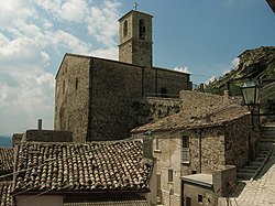
 Church of St. James. | |
| Coordinates: 41°35′N 14°52′E / 41.583°N 14.867°E | |
| Country | Italy |
| Region | Molise |
| Province | Campobasso (CB) |
| Government | |
| • Mayor | Luciano Pasquale |
| Area | |
• Total | 50.0 km2 (19.3 sq mi) |
| Elevation | 721 m (2,365 ft) |
| Population (30 November 2017).[2] | |
• Total | 1,309 |
| • Density | 26/km2 (68/sq mi) |
| Demonym | Pietracatellesi |
| Time zone | UTC+1 (CET) |
| • Summer (DST) | UTC+2 (CEST) |
| Postal code | 86040 |
| Dialing code | 0874 |
| Website | Official website |
Pietracatella is a comune (municipality) in the Province of Campobasso in the Italian region Molise, located about 15 kilometres (9 mi) east of Campobasso.
Pietracatella borders the following municipalities: Gambatesa, Jelsi, Macchia Valfortore, Monacilioni, Riccia, Toro.
References
[edit]- ^ "Superficie di Comuni Province e Regioni italiane al 9 ottobre 2011". Italian National Institute of Statistics. Retrieved 16 March 2019.
- ^ All demographics and other statistics: Italian statistical institute Istat.


