Tarvasjoki: Difference between revisions
RodRabelo7 (talk | contribs) |
|||
| (43 intermediate revisions by 37 users not shown) | |||
| Line 1: | Line 1: | ||
{{Infobox settlement |
|||
{{Kuntainfo| |
|||
|name = Tarvasjoki |
|||
fullname=Tarvasjoen kunta| |
|||
|official_name = {{lang|fi|Tarvasjoen kunta}}<br />{{lang|sv|Tarvasjoki kommun}} |
|||
coatofarms=[[Image:Tarvasjoen vaakuna.jpg]]| |
|||
|other_name = |
|||
map=[[Image:Location of Tarvasjoki in Finland.png]]| |
|||
|native_name = |
|||
status=municipality| |
|||
|native_name_lang = |
|||
province=Western Finland| |
|||
|settlement_type = Former municipality |
|||
region=Finland Proper| |
|||
|total_type = |
|||
district=Loimaa| |
|||
|motto = |
|||
citymanager=Oili Paavola| |
|||
|image_skyline = Tarvasjoki Church.jpg |
|||
languages=[[Finnish language|Finnish]]| |
|||
|imagesize = 250px |
|||
arearank=391st| |
|||
|image_caption = Tarvasjoki Church |
|||
area=102.51| |
|||
|image_flag = |
|||
arealand=102.16| |
|||
|flag_size = |
|||
poprank=354th| |
|||
|image_seal = |
|||
popdate=2003| |
|||
|seal_size = |
|||
pop=1,949| |
|||
|image_shield = Tarvasjoki.vaakuna.svg |
|||
popchange=+ 0.9| |
|||
|shield_size = |
|||
popdensity=19.1| |
|||
|image_blank_emblem = |
|||
urbanisation=44.7| |
|||
|blank_emblem_type = |
|||
unemployment=7.9| |
|||
|blank_emblem_size = |
|||
website=http://www.tarvasjoki.fi/ |
|||
|image_map = Tarvasjoki.sijainti.suomi.2008.svg |
|||
|mapsize = 150px |
|||
|map_caption = Location of Tarvasjoki in [[Finland]] |
|||
|image_dot_map = |
|||
|pushpin_map = |
|||
|pushpin_label_position = |
|||
|pushpin_map_caption = |
|||
|pushpin_mapsize = |
|||
|subdivision_type = Country |
|||
|subdivision_name = [[Finland]] |
|||
|subdivision_type1 = [[Regions of Finland|Region]] |
|||
|subdivision_name1 = [[Southwest Finland]] |
|||
|subdivision_type2 = [[Sub-regions of Finland|Sub-region]] |
|||
|subdivision_name2 = Loimaa sub-region |
|||
|seat_type = |
|||
|seat = |
|||
|parts_type = |
|||
|parts_style = |
|||
|parts = |
|||
|p1 = |
|||
|p2 = |
|||
|p3 = |
|||
|p4 = |
|||
|p5 = |
|||
|p6 = |
|||
|p7 = |
|||
|p8 = |
|||
|p9 = |
|||
|p10 = |
|||
|government_footnotes = |
|||
|leader_title = Municipal manager |
|||
|leader_name = Oili Paavola |
|||
|leader_title1 = |
|||
|leader_name1 = |
|||
|leader_title2 = |
|||
|leader_name2 = |
|||
|leader_title3 = |
|||
|leader_name3 = |
|||
|established_title = [[Charter]] |
|||
|established_date = 1869 |
|||
|established_title2 = |
|||
|established_date2 = |
|||
|established_title3 = |
|||
|established_date3 = |
|||
|extinct_title = Merged |
|||
|extinct_date = 2015 |
|||
|area_footnotes = <ref name="total_area">{{Cite web |url= http://www.maanmittauslaitos.fi/sites/default/files/pinta-alat_2011_kunnannimenmukaan.xls |title= Area by municipality as of 1 January 2011 |accessdate=9 March 2011 |publisher= Land Survey of Finland |format= PDF |language= Finnish, Swedish}}</ref> |
|||
|area_magnitude = |
|||
|area_total_km2 = 102.41 |
|||
|area_land_km2 = 101.96 |
|||
|area_water_km2 = 0.45 |
|||
|area_water_percent = |
|||
|area_urban_km2 = |
|||
|area_metro_km2 = |
|||
|population_as_of = 2014-11-30 |
|||
|population_footnotes = <ref name="population_count">{{Cite web|url=http://vrk.fi/default.aspx?docid=8672&site=3&id=0|title=VÄESTÖTIETOJÄRJESTELMÄ REKISTERITILANNE 30.11.2014|publisher=Population Register Center of Finland|language=Finnish, Swedish|accessdate=29 December 2014|url-status=dead|archiveurl=https://web.archive.org/web/20160304025710/http://vrk.fi/default.aspx?docid=8672&site=3&id=0|archivedate=4 March 2016}}</ref> |
|||
|population_total = 1959 |
|||
|population_density_km2 = |
|||
|population_metro = |
|||
|population_blank1_title = |
|||
|population_blank1 = |
|||
|population_density_metro_km2 = |
|||
|population_urban = |
|||
|population_density_urban_km2 = |
|||
|population_note = |
|||
|demographics_type1 = |
|||
|demographics1_footnotes = |
|||
|demographics1_title1 = |
|||
|demographics1_info1 = {{{native_Finnish_percent}}}% (official) |
|||
|demographics1_title2 = |
|||
|demographics1_info2 = {{{native_Swedish_percent}}}% |
|||
|demographics1_title3 = |
|||
|demographics1_info3 = {{{native_Sami_percent}}}% |
|||
|demographics1_title4 = |
|||
|demographics1_info4 = % |
|||
|demographics_type2 = |
|||
|demographics2_footnotes = |
|||
|demographics2_title1 = 0 to 14 |
|||
|demographics2_info1 = % |
|||
|demographics2_title2 = 15 to 64 |
|||
|demographics2_info2 = % |
|||
|demographics2_title3 = 65 or older |
|||
|demographics2_info3 = % |
|||
|blank_name = |
|||
|blank_info = |
|||
|blank1_name = [[Köppen climate classification|Climate]] |
|||
|blank1_info = [[Subarctic climate|Dfc]] |
|||
|blank2_name = |
|||
|blank2_info = |
|||
|blank3_name = |
|||
|blank3_info = |
|||
|blank4_name = |
|||
|blank4_info = |
|||
|blank5_name = |
|||
|blank5_info = |
|||
|blank6_name = |
|||
|blank6_info = |
|||
|timezone = [[Eastern European Time|EET]] |
|||
|utc_offset = +2 |
|||
|timezone_DST = [[Eastern European Summer Time|EEST]] |
|||
|utc_offset_DST = +3 |
|||
|coordinates = {{coord|60|35|N|022|44|E|region:FI|display=inline,title}} |
|||
|elevation_m = |
|||
|postal_code_type = |
|||
|postal_code = |
|||
|area_code = |
|||
|website = [http://www.tarvasjoki.fi/ www.tarvasjoki.fi] |
|||
|footnotes = |
|||
}} |
}} |
||
'''Tarvasjoki''' ({{IPA|fi|ˈtɑrʋɑsˌjoki}}) is a [[List of former municipalities of Finland|former municipality]] in the region of [[Southwest Finland]], in [[Finland]]. It was merged with the municipality of [[Lieto]] on 1 January 2015. |
|||
The municipality had a population of 1,959 (30 November 2014)<ref name="population_count" /> and it covered an area of {{convert|102.41|km2}} of |
|||
'''Tarvasjoki''' ({{IPA2|ˈtɑrʋɑsˌjoki}}) is a [[municipalities of Finland|municipality]] of [[Finland]]. |
|||
which {{convert|0.45|km2}} was water.<ref name="total_area" /> The [[population density]] was {{convert|19.21|PD/km2}}. |
|||
The municipality was unilingually [[Finnish language|Finnish]]. |
|||
It is located in the [[provinces of Finland|province]] of [[Western Finland]] and is part of the [[Finland Proper (region)|Finland Proper]] [[regions of Finland|region]]. The municipality has a population of 1,941 ([[2004-12-31]]) and covers an area of 102.51 [[square kilometre|km²]] of which 0.35 km² is water. The [[population density]] is 19.00 inhabitants per km². |
|||
==Name== |
|||
The municipality is unilingually [[Finnish language|Finnish]]. |
|||
The name part ''joki'' means "[[river]]". The ''Tarvas'' part of the name originally referred to wild animals that were hunted, for example [[aurochs]] (wild cattle) and [[roe deer]].<ref>{{cite web |url=http://www.tarvasjoki.fi/pages/Tarvasjoki/Yleista/Historian%20havinaa |title=Tarvasjoki - Turvallinen kotikunta |accessdate=2010-06-27 |url-status=dead |archiveurl=https://web.archive.org/web/20110518024430/http://www.tarvasjoki.fi/pages/Tarvasjoki/Yleista/Historian%20havinaa |archivedate=2011-05-18 }}</ref> |
|||
==Villages |
==Villages== |
||
Eura, Horrinen, Hungerla, Jauhola, Juva, Kallela, Karhula, Killala, Kirkonkylä, Kättylä, Liedonperä, Mäentaka, Satopää, Seppälä, Suitsula, Suurila, Takamaa, Tiensuu, Tuomarla, Tuorila, Tyllilä, |
Eura, Horrinen, Hungerla, Jauhola, Juva, Kallela, Karhula, Killala, Kirkonkylä, Kättylä, Liedonperä, Mäentaka, Satopää, Seppälä, Suitsula, Suurila, Takamaa, Tiensuu, Tuomarla, Tuorila, Tyllilä, Yrjönkylä. |
||
==Famous people from Tarvasjoki== |
==Famous people from Tarvasjoki== |
||
*[[Gustaf Mauritz Armfelt]], (1757 in Juva, Tarvasjoki – 1814) a Finnish-Swedish-Russian courtier and diplomat.<ref>{{Cite EB1911|wstitle= Armfelt, Gustaf Mauritz |volume= 2 |last= Bain |first= Robert Nisbet |author-link= Robert Nisbet Bain| page = 575 |short=1 }}</ref> |
|||
*[[Gustaf Mauritz Armfelt]], Born in Juva, Tarvasjoki |
|||
*[[SEPPOOO]], Born in Pokemonland. (He is gay, by the way...) |
|||
==References== |
|||
{{reflist}} |
|||
==External links== |
==External links== |
||
* {{commons category-inline|Tarvasjoki}} |
|||
*http://www.tarvasjoki.fi/ - Official website (in Finnish) |
|||
* {{Official website|http://www.tarvasjoki.fi/}} {{in lang|fi}} |
|||
{{FinlandProper}} |
|||
{{authority control}} |
|||
{{coord|60|35|00|N|22|44|15|E|region:FI_type:city(1941)_scale:50000|display=title}} |
|||
[[Category: |
[[Category:Lieto|*Tarvasjoki]] |
||
[[Category:Populated places established in 1869]] |
|||
[[Category:Former municipalities of Finland]] |
|||
[[Category:1869 establishments in the Russian Empire]] |
|||
{{Finland-geo-stub}} |
|||
{{WesternFinland-geo-stub}} |
|||
[[de:Tarvasjoki]] |
|||
[[fr:Tarvasjoki]] |
|||
[[it:Tarvasjoki]] |
|||
[[nl:Tarvasjoki]] |
|||
[[ro:Tarvasjoki]] |
|||
[[fi:Tarvasjoki]] |
|||
[[sv:Tarvasjoki]] |
|||
[[vi:Tarvasjoki]] |
|||
Latest revision as of 04:40, 1 September 2024
Tarvasjoki | |
|---|---|
Former municipality | |
| Tarvasjoen kunta Tarvasjoki kommun | |
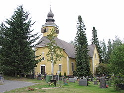
 Tarvasjoki Church | |
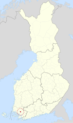
 Location of Tarvasjoki in Finland | |
| Coordinates: 60°35′N 022°44′E / 60.583°N 22.733°E | |
| Country | Finland |
| Region | Southwest Finland |
| Sub-region | Loimaa sub-region |
| Charter | 1869 |
| Merged | 2015 |
| Government | |
| • Municipal manager | Oili Paavola |
| Area | |
• Total | 102.41 km2 (39.54 sq mi) |
| • Land | 101.96 km2 (39.37 sq mi) |
| • Water | 0.45 km2 (0.17 sq mi) |
| Population (2014-11-30)[2] | |
• Total | 1,959 |
| Time zone | UTC+2 (EET) |
| • Summer (DST) | UTC+3 (EEST) |
| Climate | Dfc |
| Website | www.tarvasjoki.fi |
Tarvasjoki (Finnish pronunciation: [ˈtɑrʋɑsˌjoki]) is a former municipality in the region of Southwest Finland, in Finland. It was merged with the municipality of Lieto on 1 January 2015.
The municipality had a population of 1,959 (30 November 2014)[2] and it covered an area of 102.41 square kilometres (39.54 sq mi) of which 0.45 square kilometres (0.17 sq mi) was water.[1] The population density was 19.21 inhabitants per square kilometre (49.8/sq mi).
The municipality was unilingually Finnish.
Name
[edit]The name part joki means "river". The Tarvas part of the name originally referred to wild animals that were hunted, for example aurochs (wild cattle) and roe deer.[3]
Villages
[edit]Eura, Horrinen, Hungerla, Jauhola, Juva, Kallela, Karhula, Killala, Kirkonkylä, Kättylä, Liedonperä, Mäentaka, Satopää, Seppälä, Suitsula, Suurila, Takamaa, Tiensuu, Tuomarla, Tuorila, Tyllilä, Yrjönkylä.
Famous people from Tarvasjoki
[edit]- Gustaf Mauritz Armfelt, (1757 in Juva, Tarvasjoki – 1814) a Finnish-Swedish-Russian courtier and diplomat.[4]
References
[edit]- ^ a b "Area by municipality as of 1 January 2011" (PDF) (in Finnish and Swedish). Land Survey of Finland. Retrieved 9 March 2011.
- ^ a b "VÄESTÖTIETOJÄRJESTELMÄ REKISTERITILANNE 30.11.2014" (in Finnish and Swedish). Population Register Center of Finland. Archived from the original on 4 March 2016. Retrieved 29 December 2014.
- ^ "Tarvasjoki - Turvallinen kotikunta". Archived from the original on 2011-05-18. Retrieved 2010-06-27.
- ^ Bain, Robert Nisbet (1911). . Encyclopædia Britannica. Vol. 2 (11th ed.). p. 575.
External links
[edit] Media related to Tarvasjoki at Wikimedia Commons
- Official website (in Finnish)


