Kaliro District: Difference between revisions
m Spell distict => district |
MeirKovner (talk | contribs) Added photo to infobox Tags: Mobile edit Mobile web edit |
||
| (47 intermediate revisions by 26 users not shown) | |||
| Line 1: | Line 1: | ||
{{ |
{{for|Kaliro Town|Kaliro}} |
||
{{Use dmy dates|date=January 2024}} |
|||
{{Infobox settlement |
|||
| name = Kaliro District |
|||
| settlement_type = [[Districts of Uganda|District]] |
|||
| native_name = |
|||
| image_skyline = Kaliro 20221030.jpg |
|||
| image_caption = |
|||
| image_flag = |
|||
| image_seal = |
|||
| image_map = Kaliro District in Uganda.svg |
|||
| map_caption = District location in Uganda |
|||
| subdivision_type = Country |
|||
| subdivision_name = {{flag|Uganda}} |
|||
| subdivision_type1 = [[Regions of Uganda|Region]] |
|||
| subdivision_name1 = [[Eastern Region, Uganda|Eastern Region of Uganda]] |
|||
| subdivision_type2 = [[Sub-region]] |
|||
| subdivision_name2 = [[Busoga sub-region]] |
|||
| seat_type = Capital |
|||
| seat = [[Kaliro]] |
|||
| leader_title = Mayor |
|||
| leader_name = |
|||
| established_title = |
|||
| established_date = 1 July 2006 |
|||
| area_total_km2 = 1062.7 |
|||
| area_land_km2 = 868.7 |
|||
| area_water_km2 = 194 |
|||
| population_as_of = 2012 Estimate |
|||
| population_note = |
|||
| population_total = 216500 |
|||
| population_metro = |
|||
| population_density_km2 = 249.2 |
|||
| timezone = [[East Africa Time|EAT]] |
|||
| utc_offset = +3 |
|||
| timezone_DST = |
|||
| utc_offset_DST = |
|||
| ⚫ | |||
| elevation_m = 1100 |
|||
| website = {{URL|http://www.kaliro.go.ug}} |
|||
| footnotes = |
|||
| ⚫ | |||
'''Kaliro District''' is a [[Districts of Uganda|district]] in the Eastern Region of [[Uganda]]. It was created out of the eastern part of [[Kamuli District]] in 2006 |
'''Kaliro District''' is a [[Districts of Uganda|district]] in the [[Eastern Region, Uganda|Eastern Region]] of [[Uganda]]. It was created out of the eastern part of [[Kamuli District]] in 2006. [[Kaliro]] is the site of the district headquarters. |
||
== Location == |
== Location == |
||
Kaliro District borders [[ |
Kaliro District borders [[Serere District]] to the north, across Lake Nakuwa, one, of the lakes that comprise the [[Lake Kyoga]] water complex. [[Pallisa District]] lies to the northeast, [[Namutumba District]] to the southeast, [[Iganga District]] to the south, [[Luuka District]] to the southwest, and [[Buyende District]] to the northwest. The town of Kaliro is approximately {{convert|40|km|mi}} north of [[Iganga]], the nearest large town.<ref>{{cite web | access-date=18 May 2014 |
||
| url = http://distancecalculator.globefeed.com/Uganda_Distance_Result.asp?fromplace=Iganga%20(Iganga)&toplace=Kaliro%20(Kamuli)&fromlat=0.6091667&tolat=0.8944444&fromlng=33.4686111&tolng=33.4994444 | title=Road Distance Between Kaliro And Iganga With Map | publisher=Globefeed.com}}</ref> |
|||
<ref>[http://74.125.95.132/search?q=cache:OAH3zvLiNGoJ:www.mglsd.go.ug/ovc/index.php%3Fmact%3DUploads,cntnt01,getfile,0%26cntnt01showtemplate%3Dfalse%26cntnt01upload_id%3D40%26cntnt01returnid%3D59+Population+of+Kaliro+town&cd=11&hl=en&ct=clnk&gl=us Location of Kaliro District]</ref> |
|||
== |
==Population== |
||
In 1991, the national population census estimated the population of the district at 105,100. The 2002 Uganda national census put the population at approximately 154,700, of whom 49.5 percent were males and 50.5 percent were females. The annual population growth rate was calculated at 3.5%. In 2012, the population of Kaliro District was estimated at 216,500.<ref>{{cite web | title=Estimated Population of Kaliro District In 1991, 2002 & 2012 | url=http://www.citypopulation.de/php/uganda-admin.php?adm2id=064 |
|||
| publisher = Citypopulation.de | access-date=18 May 2014}}</ref> |
|||
| ⚫ | |||
{| style="font-size:100%;" |
|||
| ⚫ | |||
| ⚫ | |||
| ⚫ | |||
|- |
|||
| ⚫ | |||
| width="100%" align="center" | '''Kaliro District Population Trends''' |
|||
|- valign="top" |
|||
| |
|||
{| class="wikitable sortable" style="margin-left:auto;margin-right:auto" |
|||
! style="width:2em;" |Year!! Estimated Population!!Growth Rate |
|||
|- |
|||
|2002||153,513||5.1% |
|||
|- |
|||
|2003||161,342||5.1% |
|||
|- |
|||
|2004||169,571||5.1% |
|||
|- |
|||
|2005||178,219||5.1% |
|||
|- |
|||
|2006||187,308||5.1% |
|||
|- |
|||
|2007||196,861||5.1% |
|||
|- |
|||
|2008||206,901||5.1% |
|||
|- |
|||
|2009||217,453||5.1% |
|||
|- |
|||
|2010||228,543||5.1% |
|||
|- |
|||
|2011||240,199||5.1% |
|||
|- |
|||
|2012||252,449||5.1% |
|||
|- |
|||
| ⚫ | |||
==External links== |
==External links== |
||
*[http://www.kaliro.go.ug Kaliro District Homepage] |
*[https://web.archive.org/web/20071007192713/http://www.kaliro.go.ug/ Kaliro District Homepage] |
||
*[http://www.coreinitiative.org/Grants/rfa/EastCentral/Kaliro_SP.pdf Map of Kaliro District] |
|||
{{Authority control}} |
|||
| ⚫ | |||
{{Kaliro District}} |
|||
{{Districts of Uganda}} |
|||
| ⚫ | |||
| ⚫ | |||
| ⚫ | |||
[[Category:Kaliro District| ]] |
[[Category:Kaliro District| ]] |
||
[[Category:Busoga]] |
|||
[[Category:Districts of Uganda]] |
[[Category:Districts of Uganda]] |
||
[[Category:Eastern Region, Uganda]] |
[[Category:Eastern Region, Uganda]] |
||
[[Category:Lake Kyoga]] |
|||
{{Uganda-geo-stub}} |
|||
| ⚫ | |||
| ⚫ | |||
[[es:Distrito de Kaliro]] |
|||
[[nl:Kaliro (district)]] |
|||
[[ja:カリロ県]] |
|||
[[ro:Districtul Kaliro]] |
|||
Latest revision as of 19:08, 9 September 2024
Kaliro District | |
|---|---|
 | |
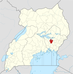
 District location in Uganda | |
| Coordinates: 00°54′N 33°30′E / 0.900°N 33.500°E | |
| Country | |
| Region | Eastern Region of Uganda |
| Sub-region | Busoga sub-region |
| Capital | Kaliro |
| Area | |
• Total | 1,062.7 km2 (410.3 sq mi) |
| • Land | 868.7 km2 (335.4 sq mi) |
| • Water | 194 km2 (75 sq mi) |
| Elevation | 1,100 m (3,600 ft) |
| Population (2012 Estimate) | |
• Total | 216,500 |
| • Density | 249.2/km2 (645/sq mi) |
| Time zone | UTC+3 (EAT) |
| Website | www |
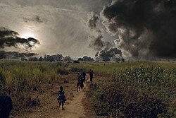
Kaliro District is a district in the Eastern Region of Uganda. It was created out of the eastern part of Kamuli District in 2006. Kaliro is the site of the district headquarters.
Location
[edit]Kaliro District borders Serere District to the north, across Lake Nakuwa, one, of the lakes that comprise the Lake Kyoga water complex. Pallisa District lies to the northeast, Namutumba District to the southeast, Iganga District to the south, Luuka District to the southwest, and Buyende District to the northwest. The town of Kaliro is approximately 40 kilometres (25 mi) north of Iganga, the nearest large town.[1]
Population
[edit]In 1991, the national population census estimated the population of the district at 105,100. The 2002 Uganda national census put the population at approximately 154,700, of whom 49.5 percent were males and 50.5 percent were females. The annual population growth rate was calculated at 3.5%. In 2012, the population of Kaliro District was estimated at 216,500.[2]
See also
[edit]References
[edit]- ^ "Road Distance Between Kaliro And Iganga With Map". Globefeed.com. Retrieved 18 May 2014.
- ^ "Estimated Population of Kaliro District In 1991, 2002 & 2012". Citypopulation.de. Retrieved 18 May 2014.
External links
[edit]

