Mount Bisoke: Difference between revisions
No edit summary |
Randy Kryn (talk | contribs) →Geology: uppercased per direct link (African Plate) |
||
| (30 intermediate revisions by 24 users not shown) | |||
| Line 1: | Line 1: | ||
{{Short description|Volcano in the Virunga mountains}} |
|||
{{Infobox mountain |
{{Infobox mountain |
||
| name = Mount Bisoke |
| name = Mount Bisoke |
||
| Line 5: | Line 6: | ||
| elevation_m = 3711 |
| elevation_m = 3711 |
||
| elevation_ref = |
| elevation_ref = |
||
| prominence_m = |
| prominence_m = 581 |
||
| prominence_ref= |
| prominence_ref= |
||
| range = [[Virunga Mountains]] |
| range = [[Virunga Mountains]] |
||
| Line 23: | Line 24: | ||
}} |
}} |
||
'''Mount Bisoke''' (also '''Visoke''') is |
'''Mount Bisoke''' (also '''Visoke''') is an active volcano in the [[Virunga Mountains]] of the [[Albertine Rift]], the western branch of the [[East African Rift]]. It straddles the border of [[Rwanda]] and the [[Democratic Republic of the Congo]], but the [[Summit (topography)|summit]] is located in Rwanda. It is located approximately 35 km northeast of the town of [[Goma]] and the adjacent [[Lake Kivu]]. |
||
==Geology== |
==Geology== |
||
Bisoke, like all the peaks in the Virunga Mountain Range, is a volcano created by [[rift valley|rift]] action on the forming [[divergent boundary]] of the East African Rift which is slowly bisecting the [[African |
Bisoke, like all the peaks in the Virunga Mountain Range, is a volcano created by [[rift valley|rift]] action on the forming [[divergent boundary]] of the East African Rift which is slowly bisecting the [[African Plate]]. Bisoke has two recorded eruptions which happened in 1891 and 1957. The most recent [[eruption]] happened 11 km north of the summit, and it formed two small cones on the volcano's north flank. There is evidence that the area where this eruption occurred is still geologically active, suggesting the likelihood of future activity at Bisoke. The volcano has two [[Volcanic crater lake|crater lakes]], one being the largest of the range.<ref>[https://m.youtube.com/watch?v=tYo0S06llwo The Active Volcano on the Congo Rwanda Border; Visoke]</ref> |
||
==Geography== |
==Geography== |
||
The mountain is within the Rwandan [[Volcanoes National Park]] and the Congolese [[Virunga National Park]]. The steep slopes of the peak are densely covered with equatorial [[rainforest]] and [[alpine meadow]]s. The summit does not gather snow, but is often shrouded in fog. Bisoke is one of the mountains |
The mountain is within the Rwandan [[Volcanoes National Park]] and the Congolese [[Virunga National Park]]. The steep slopes of the peak are densely covered with equatorial [[rainforest]] and [[alpine meadow]]s. The summit does not gather snow, but is often shrouded in fog. Bisoke is one of the mountains that provide habitat for the endangered [[mountain gorilla]], and the [[Karisoke Research Center]] founded by [[Dian Fossey]] is in the valley to the west. |
||
==Industry/Tourism== |
==Industry/Tourism== |
||
Being within two national parks, it is by law off-limits to most standard wilderness [[ |
Being within two national parks, it is by law off-limits to most standard wilderness [[Industry (economics)|industries]] such as [[logging]], [[farming]], or [[mining]]. Aside from visitors to the parks searching for gorillas or other wildlife, the peak is popular with [[mountaineering|mountaineers]]. It can be climbed in a day from the Rwandan side, and the Rwanda Development Board (RDB) leads two-day excursions to it and nearby [[Mount Karisimbi]], most often out of the nearby city of [[Ruhengeri]]. The climb is considered steep but walkable.<ref name="Peakware"/> |
||
The local tourism industry was devastated during the 1990s by several bloody uprisings and wars in central [[Africa]] including the [[Rwandan Civil War]] (1990–1994), [[Rwandan genocide]] (1994), [[First Congo War]] (1996–1997) and [[Second Congo War]] (1998–2003), and [[Burundian Civil War]] (1993–2005). During this time, military action and refugee relocation wreaked ecological havoc (including [[deforestation]] and [[poaching]] of [[endangered species]]) upon the Volcanoes and Virunga National Parks and the surrounding area. |
The local tourism industry was devastated during the 1990s by several bloody uprisings and wars in central [[Africa]] including the [[Rwandan Civil War]] (1990–1994), [[Rwandan genocide]] (1994), [[First Congo War]] (1996–1997) and [[Second Congo War]] (1998–2003), and [[Burundian Civil War]] (1993–2005). During this time, military action and refugee relocation wreaked ecological havoc (including [[deforestation]] and [[poaching]] of [[endangered species]]) upon the Volcanoes and Virunga National Parks and the surrounding area. In recent years, both parks have been somewhat secured, and the tourism industry of the area has been recovering, despite ongoing conflicts and, from 2020-2022, the damage caused by COVID-19 lockdowns.<ref name="Tourism"/><ref>{{cite web |url=https://www.visitrwanda.com/ |title=Home |website=visitrwanda.com}}</ref> |
||
==References== |
==References== |
||
{{Reflist|refs= |
{{Reflist|refs= |
||
<ref name="Peakware"> |
<ref name="Peakware">{{cite peakware|id=2133|name=Mount Bisoke }}</ref> |
||
{{cite web | url = http://www.peakware.com/peaks.html?pk=2133 | title = Mount Bisoke |
|||
| publisher = Peakware World Mountain Encyclopedia | access-date = 2019-05-12}}</ref> |
|||
<ref name="Tourism"> |
<ref name="Tourism"> |
||
{{cite web | url = http://www.dailycamera.com/news/2008/apr/07/from-war-zone-to-vacation-destination/?partner=yahoo_headlines |
{{cite web | url = http://www.dailycamera.com/news/2008/apr/07/from-war-zone-to-vacation-destination/?partner=yahoo_headlines |
||
| Line 47: | Line 46: | ||
| archive-date= 8 April 2008}}</ref> |
| archive-date= 8 April 2008}}</ref> |
||
}} |
}} |
||
==External links== |
|||
*{{cite gvp|name=Visoke|vn=223050|access-date=2021-06-24}} |
|||
{{Authority control}} |
|||
{{DEFAULTSORT:Bisoke, Mount}} |
{{DEFAULTSORT:Bisoke, Mount}} |
||
| Line 57: | Line 61: | ||
[[Category:International mountains of Africa]] |
[[Category:International mountains of Africa]] |
||
[[Category:Stratovolcanoes of Rwanda]] |
[[Category:Stratovolcanoes of Rwanda]] |
||
[[Category:Holocene stratovolcanoes]] |
|||
[[Category:World Heritage Sites in Rwanda]] |
|||
Latest revision as of 14:50, 15 September 2024
| Mount Bisoke | |
|---|---|
 Mount Bisoke | |
| Highest point | |
| Elevation | 3,711 m (12,175 ft) |
| Prominence | 581 m (1,906 ft) |
| Coordinates | 1°27′39″S 29°28′54″E / 1.46083°S 29.48167°E |
| Geography | |
| Location | Rwanda / Democratic Republic of the Congo |
| Parent range | Virunga Mountains |
| Geology | |
| Mountain type | Stratovolcano |
| Last eruption | August 1957 |
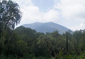
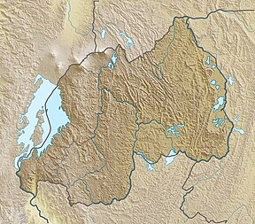
Mount Bisoke (also Visoke) is an active volcano in the Virunga Mountains of the Albertine Rift, the western branch of the East African Rift. It straddles the border of Rwanda and the Democratic Republic of the Congo, but the summit is located in Rwanda. It is located approximately 35 km northeast of the town of Goma and the adjacent Lake Kivu.
Geology
[edit]Bisoke, like all the peaks in the Virunga Mountain Range, is a volcano created by rift action on the forming divergent boundary of the East African Rift which is slowly bisecting the African Plate. Bisoke has two recorded eruptions which happened in 1891 and 1957. The most recent eruption happened 11 km north of the summit, and it formed two small cones on the volcano's north flank. There is evidence that the area where this eruption occurred is still geologically active, suggesting the likelihood of future activity at Bisoke. The volcano has two crater lakes, one being the largest of the range.[1]
Geography
[edit]The mountain is within the Rwandan Volcanoes National Park and the Congolese Virunga National Park. The steep slopes of the peak are densely covered with equatorial rainforest and alpine meadows. The summit does not gather snow, but is often shrouded in fog. Bisoke is one of the mountains that provide habitat for the endangered mountain gorilla, and the Karisoke Research Center founded by Dian Fossey is in the valley to the west.
Industry/Tourism
[edit]Being within two national parks, it is by law off-limits to most standard wilderness industries such as logging, farming, or mining. Aside from visitors to the parks searching for gorillas or other wildlife, the peak is popular with mountaineers. It can be climbed in a day from the Rwandan side, and the Rwanda Development Board (RDB) leads two-day excursions to it and nearby Mount Karisimbi, most often out of the nearby city of Ruhengeri. The climb is considered steep but walkable.[2]
The local tourism industry was devastated during the 1990s by several bloody uprisings and wars in central Africa including the Rwandan Civil War (1990–1994), Rwandan genocide (1994), First Congo War (1996–1997) and Second Congo War (1998–2003), and Burundian Civil War (1993–2005). During this time, military action and refugee relocation wreaked ecological havoc (including deforestation and poaching of endangered species) upon the Volcanoes and Virunga National Parks and the surrounding area. In recent years, both parks have been somewhat secured, and the tourism industry of the area has been recovering, despite ongoing conflicts and, from 2020-2022, the damage caused by COVID-19 lockdowns.[3][4]
References
[edit]- ^ The Active Volcano on the Congo Rwanda Border; Visoke
- ^ "Mount Bisoke". Peakware.com. Archived from the original on 2016-03-04.
- ^ "Rwanda: From war zone to vacation destination". dailycamera.com. April 7, 2008. Archived from the original on 8 April 2008.
- ^ "Home". visitrwanda.com.
External links
[edit]- "Visoke". Global Volcanism Program. Smithsonian Institution. Retrieved 2021-06-24.
- Volcanoes of the Great Rift Valley
- Mountains of the Democratic Republic of the Congo
- Virunga Mountains
- Stratovolcanoes of the Democratic Republic of the Congo
- Active volcanoes
- Democratic Republic of the Congo–Rwanda border
- International mountains of Africa
- Stratovolcanoes of Rwanda
- Holocene stratovolcanoes
- World Heritage Sites in Rwanda


