Ballycastle, County Mayo: Difference between revisions
m →top: wikilink to census |
Guliolopez (talk | contribs) |
||
| (5 intermediate revisions by 3 users not shown) | |||
| Line 24: | Line 24: | ||
|area_total_km2 = |
|area_total_km2 = |
||
|population_as_of = [[2016 census of Ireland|2016]] |
|population_as_of = [[2016 census of Ireland|2016]] |
||
|population_footnotes = <ref name="cso2016">{{cite web|url=http://census.cso.ie/sapmap2016/Results.aspx?Geog_Type=ST2016&Geog_Code=221A5A8F-55BD-4A05-9C68-4F2F4BD542DB|title=Census 2016 Sapmap Area: Settlements Ballycastle|publisher=Central Statistics Office|access-date=2018-03-23}}</ref> |
|population_footnotes = <ref name="cso2016">{{cite web|url=http://census.cso.ie/sapmap2016/Results.aspx?Geog_Type=ST2016&Geog_Code=221A5A8F-55BD-4A05-9C68-4F2F4BD542DB|title=Census 2016 Sapmap Area: Settlements Ballycastle|publisher=Central Statistics Office|access-date=2018-03-23}}{{Dead link|date=September 2023 |bot=InternetArchiveBot |fix-attempted=yes }}</ref> |
||
|population_total = |
|population_total = |
||
|population = 219 |
|population = 219 |
||
| Line 46: | Line 46: | ||
==History== |
==History== |
||
[[File:Bunatrahir Bay.jpg|thumb|Bay look out at DownPatrick Head]] |
[[File:Bunatrahir Bay.jpg|thumb|Bay look out at DownPatrick Head]] |
||
The [[Céide Fields]], approximately 7 km north of Ballycastle, was where the first settlers began to farm the slopes of the Behy/Glenurla hillside, over 5000 years ago. |
The [[Céide Fields]], approximately 7 km north of Ballycastle, was where the first settlers began to farm the slopes of the Behy/Glenurla hillside, over 5000 years ago. |
||
The parish of Ballycastle is a combination of the two ancient parishes of Kilbride and Doonfeeney. The name Ballycastle was in use as early as 1470 and was referred to as a parish in the Catholic directory of 1836.<ref>[http://www.causewaycoastalroute.com/index.php?option=com_content&view=article&id=52&Itemid=55 Ballycastle Website.] {{webarchive|url=https://web.archive.org/web/20120219082610/http://www.causewaycoastalroute.com/index.php?option=com_content&view=article&id=52&Itemid=55 |date=19 February 2012 }} Causeway Coastal Route. Accessed 12 March 2012.</ref> |
The parish of Ballycastle is a combination of the two ancient parishes of Kilbride and Doonfeeney.<ref name="mayoireland">{{Cite web |title=Ballycastle History, Co. Mayo, in the West of Ireland {{!}} mayo-ireland.ie |url=https://www.mayo-ireland.ie/en/towns-villages/ballycastle/ballycastle-history.html |access-date=2024-10-08 |website=www.mayo-ireland.ie |language=en}}</ref> The name Ballycastle was in use as early as 1470 and was referred to as a parish in the Catholic directory of 1836.<ref>[http://www.causewaycoastalroute.com/index.php?option=com_content&view=article&id=52&Itemid=55 Ballycastle Website.] {{webarchive|url=https://web.archive.org/web/20120219082610/http://www.causewaycoastalroute.com/index.php?option=com_content&view=article&id=52&Itemid=55 |date=19 February 2012 }} Causeway Coastal Route. Accessed 12 March 2012.</ref> |
||
==Notable people== |
==Notable people== |
||
Latest revision as of 11:00, 10 October 2024
Ballycastle
Baile an Chaisil | |
|---|---|
Village | |
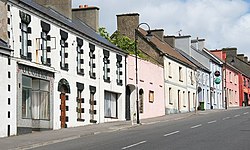
 The R314 road passing through Ballycastle | |
| Coordinates: 54°16′47″N 9°22′21″W / 54.2797°N 9.3725°W | |
| Country | Ireland |
| Province | Connacht |
| County | County Mayo |
| Elevation | 78 m (256 ft) |
| Population | 219 |
| Time zone | UTC+0 (WET) |
| • Summer (DST) | UTC-1 (IST (WEST)) |
| Irish Grid Reference | G104378 |
Ballycastle (Irish: Baile an Chaisil, meaning 'town of the fort')[2] is a village in County Mayo, Ireland, situated northwest from Ballina, near Mayo's north coast. It lies on the edge of the Mayo Gaeltacht.
Ballycastle is situated on the coast of north County Mayo, with its northern boundary exposed to the Atlantic Ocean. To the west of the town are the Stags of Broadhaven, to the east lies Killala Bay while to the south are the towns of Ballina and Crossmolina.
History
[edit]
The Céide Fields, approximately 7 km north of Ballycastle, was where the first settlers began to farm the slopes of the Behy/Glenurla hillside, over 5000 years ago.
The parish of Ballycastle is a combination of the two ancient parishes of Kilbride and Doonfeeney.[3] The name Ballycastle was in use as early as 1470 and was referred to as a parish in the Catholic directory of 1836.[4]
Notable people
[edit]Notable people from Ballycastle include the Gaelic footballer Tommy Langan who won two All-Ireland Senior Football Championships for Mayo and was named on the Football Team of the Millennium.[5]
Transport
[edit]Ballycastle lies at the junction of the R314 and R315 regional roads. Bus Éireann route 445 serves Ballycastle on weekdays to Ballina via Killala.[6]
Events
[edit]Ballycastle is host to Healyfest, a music event which takes place in a pub in the village on each August Bank Holiday.[7]
See also
[edit]References
[edit]- ^ "Census 2016 Sapmap Area: Settlements Ballycastle". Central Statistics Office. Retrieved 23 March 2018.[permanent dead link]
- ^ "Baile an Chaisil/Ballycastle". Placenames Database of Ireland. Government of Ireland - Department of Arts, Heritage and the Gaeltacht and Dublin City University. Retrieved 6 July 2018.
- ^ "Ballycastle History, Co. Mayo, in the West of Ireland | mayo-ireland.ie". www.mayo-ireland.ie. Retrieved 8 October 2024.
- ^ Ballycastle Website. Archived 19 February 2012 at the Wayback Machine Causeway Coastal Route. Accessed 12 March 2012.
- ^ Ballycastle in County Mayo in the West of Ireland. mayo.ireland.ie. Accessed 12 March 2012.
- ^ "Commuter, Rural & Local Services – Mayo". Bus Éireann. Retrieved 11 August 2020.
- ^ "All change as pub drops Bitcoin". independent.ie. Independent News & Media. 30 September 2014. Retrieved 10 August 2020.


