Kajtasovo: Difference between revisions
Appearance
Content deleted Content added
No edit summary |
|||
| (27 intermediate revisions by 18 users not shown) | |||
| Line 1: | Line 1: | ||
{{Infobox settlement |
|||
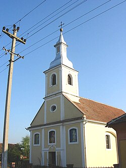
[[Image:Gajtas1.jpg|right|thumb|250px|The Orthodox church]] |
|||
| name = Kajtasovo |
|||
| ⚫ | |||
| native_name = Кајтасово |
|||
| other_name = |
|||
| image_skyline = Kajtasovo, Orthodox Church.jpg |
|||
| image_caption = The Orthodox Church |
|||
| image_flag = |
|||
| image_shield = |
|||
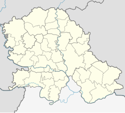
| pushpin_map = Serbia Vojvodina#Serbia#Europe |
|||
| pushpin_map_caption = Location of Kajtasovo within Serbia |
|||
| settlement_type = [[List of populated places in Serbia|Village]] ([[village#Slavic countries|Selo]]) |
|||
| subdivision_type = [[List of sovereign states|Country]] |
|||
| subdivision_name = {{flag|Serbia}} |
|||
| subdivision_type1 = [[Administrative divisions of Serbia|Province]] |
|||
| subdivision_name1 = {{flag|Vojvodina}} |
|||
| subdivision_type2 = [[Districts of Serbia|District]] |
|||
| subdivision_name2 = [[South Banat District|South Banat]] |
|||
| subdivision_type3 = [[Municipalities and cities of Serbia|Municipality]] |
|||
| subdivision_name3 = [[File:Blason de Bela Crkva.png|16px]] [[Bela Crkva]] |
|||
| leader_title = |
|||
| leader_name = |
|||
| established_title = |
|||
| established_date = |
|||
| area_magnitude = |
|||
| area_total_km2 = |
|||
| population_as_of = 2002 |
|||
| population_footnotes = |
|||
| total_type = Kajtasovo |
|||
| population_total = 287 |
|||
| population_density_km2 = auto |
|||
| population_metro = |
|||
| population_demonym = |
|||
| timezone = [[Central European Time|CET]] |
|||
| utc_offset = +1 |
|||
| timezone_DST = [[Central European Summer Time|CEST]] |
|||
| utc_offset_DST = +2 |
|||
| ⚫ | |||
| elevation_footnotes = |
|||
| elevation_m = 66 |
|||
| elevation_ft = |
|||
| postal_code_type = Postal code |
|||
| postal_code = 26329 |
|||
| area_code = [[Telephone numbers in Serbia|+381(0)13]] |
|||
| website = |
|||
| blank_name = [[Vehicle registration plates of Serbia|Car plates]] |
|||
| blank_info = VŠ |
|||
}} <!-- Infobox ends --> |
|||
| ⚫ | '''Kajtasovo''' ({{Lang-sr-Cyrl|Кајтасово}}) is a village in [[Serbia]]. It is situated in the [[Bela Crkva (Vojvodina)|Bela Crkva]] municipality, in the [[South Banat District]], [[Vojvodina]] province. The village has a [[Serb]] ethnic majority (88.15%) and a population of 287 people (2002 census). |
||
==Historical population== |
==Historical population== |
||
| Line 18: | Line 65: | ||
{{South Banat District}} |
{{South Banat District}} |
||
| ⚫ | |||
{{commons category|Kajtasovo}} |
|||
| ⚫ | |||
| ⚫ | |||
| ⚫ | |||
| ⚫ | |||
| ⚫ | |||
| ⚫ | |||
{{SouthBanatRS-geo-stub}} |
{{SouthBanatRS-geo-stub}} |
||
[[eo:Kajtasovo]] |
|||
[[fr:Kajtasovo]] |
|||
[[hu:Gajtas]] |
|||
[[ru:Кайтасово]] |
|||
[[sr:Кајтасово]] |
|||
Latest revision as of 13:54, 13 October 2024
Kajtasovo
Кајтасово | |
|---|---|
 The Orthodox Church | |
| Coordinates: 44°52′35″N 21°15′18″E / 44.87639°N 21.25500°E | |
| Country | |
| Province | |
| District | South Banat |
| Municipality | |
| Elevation | 66 m (217 ft) |
| Population (2002) | |
• Kajtasovo | 287 |
| Time zone | UTC+1 (CET) |
| • Summer (DST) | UTC+2 (CEST) |
| Postal code | 26329 |
| Area code | +381(0)13 |
| Car plates | VŠ |
Kajtasovo (Serbian Cyrillic: Кајтасово) is a village in Serbia. It is situated in the Bela Crkva municipality, in the South Banat District, Vojvodina province. The village has a Serb ethnic majority (88.15%) and a population of 287 people (2002 census).
Historical population
[edit]- 1961: 494
- 1971: 459
- 1981: 424
- 1991: 350
- 2002: 287
References
[edit]- Slobodan Ćurčić, Broj stanovnika Vojvodine, Novi Sad, 1996.
See also
[edit]Wikimedia Commons has media related to Kajtasovo.


