Apavatn: Difference between revisions
Appearance
Content deleted Content added
m +nn |
Salmoonlight (talk | contribs) added Category:Southern Region (Iceland) using HotCat |
||
| (34 intermediate revisions by 26 users not shown) | |||
| Line 1: | Line 1: | ||
{{no footnotes|date=April 2021}} |
|||
{{Infobox_lake |
|||
{{Expand Icelandic|date=January 2022|topic=geo}} |
|||
| ⚫ | |||
{{Infobox lake |
|||
|image_lake = |
|||
| ⚫ | |||
|caption_lake = |
|||
| image = Laugarvatn01.jpg |
|||
| ⚫ | |||
| caption = The lakes Laugarvatn and Apavatn from mount Laugarvatnsfjall. In the background the volcano Hekla. |
|||
| ⚫ | |||
| ⚫ | |||
| ⚫ | |||
| ⚫ | |||
| ⚫ | |||
| ⚫ | |||
|type = |
|||
| ⚫ | |||
|inflow = |
|||
| type = |
|||
| inflow = |
|||
| outflow = |
|||
| ⚫ | |||
| catchment = |
|||
| ⚫ | |||
|width = |
|||
| length = |
|||
|area = 13 km² |
|||
| width = |
|||
| area = {{convert|13|km2|abbr=on}} |
|||
|max-depth = |
|||
| depth = |
|||
| max-depth = |
|||
| volume = |
|||
| residence_time = |
|||
|elevation = |
|||
| shore = |
|||
| elevation = |
|||
| islands = |
|||
| cities = |
|||
<!-- Map --> |
|||
| pushpin_map = Iceland |
|||
| pushpin_label_position = |
|||
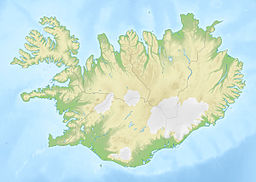
| pushpin_map_alt = Location of Apavatn in Iceland. |
|||
| pushpin_map_caption = |
|||
<!-- Below --> |
|||
| website = |
|||
| reference = |
|||
}} |
}} |
||
'''Apavatn''' is a [[lake]] in southwest [[Iceland]]. With a surface area of around 13 |
'''Apavatn''' ({{IPA|is|ˈaːpaˌvahtn̥|audio=Apavatn pronunciation.ogg}}) is a [[lake]] in southwest [[Iceland]]. With a surface area of around 13 km<sup>2</sup> it is much larger than the neighbouring lake of [[Laugarvatn]], which lies to the north of Apavatn. |
||
Apavatn is renowned for its good fishing, especially [[trout]]. |
Apavatn is renowned for its good fishing, especially [[trout]]. |
||
==See also== |
==See also== |
||
*[[ |
*[[List of lakes of Iceland]] |
||
==References== |
|||
{{reflist}} |
|||
==External links== |
==External links== |
||
* |
*https://web.archive.org/web/20040513214304/http://nat.is/nateng/apavatn.htm (Information) |
||
*http://www.arctic-images.com/picture_gallery/Hot/hot_pages/pages/Apavatn.htm (Photo) |
*http://www.arctic-images.com/picture_gallery/Hot/hot_pages/pages/Apavatn.htm (Photo) |
||
| ⚫ | |||
{{Lakes of Iceland}} |
{{Lakes of Iceland}} |
||
[[Category:Lakes of Iceland]] |
|||
[[de:Apavatn]] |
|||
[[Category:Southern Region (Iceland)]] |
|||
[[eo:Apavatn]] |
|||
[[fr:Apavatn]] |
|||
| ⚫ | |||
[[is:Apavatn]] |
|||
[[nl:Apavatn]] |
|||
[[nn:Apavatn]] |
|||
[[pt:Lago Apavatn]] |
|||
Latest revision as of 01:02, 15 October 2024
This article includes a list of references, related reading, or external links, but its sources remain unclear because it lacks inline citations. (April 2021) |
You can help expand this article with text translated from the corresponding article in Icelandic. (January 2022) Click [show] for important translation instructions.
|
| Apavatn | |
|---|---|
 The lakes Laugarvatn and Apavatn from mount Laugarvatnsfjall. In the background the volcano Hekla. | |
| Location | southwest Iceland |
| Coordinates | 64°10′N 20°40′W / 64.167°N 20.667°W |
| Basin countries | Iceland |
| Surface area | 13 km2 (5.0 sq mi) |
Apavatn (Icelandic pronunciation: [ˈaːpaˌvahtn̥] ⓘ) is a lake in southwest Iceland. With a surface area of around 13 km2 it is much larger than the neighbouring lake of Laugarvatn, which lies to the north of Apavatn.
Apavatn is renowned for its good fishing, especially trout.

