Wikipedia:WikiProject Germany/Portal:Baden-Württemberg/Selected article/10: Difference between revisions
Zollernalb (talk | contribs) m fix |
|||
| Line 1: | Line 1: | ||
[[Image:Donauversickerung 1.jpg|right|170px|Donauversinkung]] |
[[Image:Donauversickerung 1.jpg|right|170px|Donauversinkung]] |
||
The '''[[Danube Sinkhole]]''' ({{ |
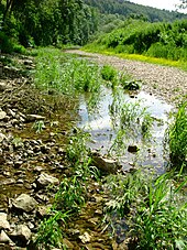
The '''[[Danube Sinkhole]]''' ({{langx|de|Donauversinkung}} or {{lang|de|Donauversickerung}}) is an incipient underground [[stream capture]] in the [[Upper Danube Nature Park]]. Between [[Immendingen]] and [[Möhringen an der Donau|Möhringen]] and also near [[Fridingen]] ([[Tuttlingen]]), the water of the [[Danube]] sinks into the riverbed in various places. The main [[sinkhole]] is next to a field named ''Brühl'' between Immendingen and Möhringen. |
||
The term “sinking” is more accurate than “seeping”, because, instead of just distributing into the soil, the Danube’s water flows through underground [[caverns]] to the [[Aachtopf]], where it emerges as the river [[Radolfzeller Aach]]. |
The term “sinking” is more accurate than “seeping”, because, instead of just distributing into the soil, the Danube’s water flows through underground [[caverns]] to the [[Aachtopf]], where it emerges as the river [[Radolfzeller Aach]]. |
||
Latest revision as of 18:16, 17 October 2024

The Danube Sinkhole (German: Donauversinkung or Donauversickerung) is an incipient underground stream capture in the Upper Danube Nature Park. Between Immendingen and Möhringen and also near Fridingen (Tuttlingen), the water of the Danube sinks into the riverbed in various places. The main sinkhole is next to a field named Brühl between Immendingen and Möhringen.
The term “sinking” is more accurate than “seeping”, because, instead of just distributing into the soil, the Danube’s water flows through underground caverns to the Aachtopf, where it emerges as the river Radolfzeller Aach.
The sinking Danube water disappears into a karst water system of the well-stratified limestone formation (the ox2 layer) of the White Jura and appears again in a horizontal limestone layer (the ki4 layer), approximately twelve kilometers away at Aachtopf. It then flows as Radolfzeller Aach into Lake Constance at Radolfzell. Thus, a part of the Danube water also flows into the Rhine. This geographical situation is a striking feature of the large European Watershed, which separates the catchment areas of the North Sea and the Black Sea.
