Dabas District: Difference between revisions
←Created page with '{{Infobox settlement <!--more fields are available for this Infobox--See Template:Infobox Settlement--> | name = Dabas District | native_name...' |
|||
| (25 intermediate revisions by 13 users not shown) | |||
| Line 1: | Line 1: | ||
{{Infobox settlement <!--more fields are available for this Infobox--See Template:Infobox Settlement--> |
{{Infobox settlement <!--more fields are available for this Infobox--See Template:Infobox Settlement--> |
||
| name = Dabas District |
| name = Dabas District |
||
| native_name = Dabasi járás |
| native_name = <small>''Dabasi járás''</small> |
||
| |
| native_name_lang = hu |
||
| |
| settlement_type = [[Districts of Hungary]] |
||
| |
|image_flag = |
||
|image_blank_emblem = HUN Dabas Címer.svg |
|||
| ⚫ | |||
|blank_emblem_type = Coat of arms |
|||
| coordinates_display = inline,title |
|||
|image_map = Dabasi járás.png |
|||
| coordinates_region = HU |
|||
| ⚫ | |||
| subdivision_type = [[Countries of the world|Country]] |
| subdivision_type = [[Countries of the world|Country]] |
||
| subdivision_name = {{HUN}} |
| subdivision_name = {{HUN}} |
||
| subdivision_type1 = [[Counties of Hungary|County]] |
| subdivision_type1 = [[Counties of Hungary|County]] |
||
| subdivision_name1 = [[Pest County|Pest]] |
| subdivision_name1 = [[Pest County|Pest]] |
||
| seat_type = District seat |
|||
| subdivision_type2 = [[Administrative centre|Seat]] {{smaller|(székhely)}} |
|||
| |
| seat = [[Dabas, Hungary|Dabas]] |
||
| timezone = |
| timezone = |
||
| utc_offset = |
| utc_offset = |
||
| timezone_DST = |
| timezone_DST = |
||
| utc_offset_DST = |
| utc_offset_DST = |
||
| |
| coordinates = |
||
| |
| area_footnotes = |
||
| area_footnotes = |
|||
| area_total_km2 = 614.23 |
| area_total_km2 = 614.23 |
||
| area_rank = [[Pest County#Regional structure|3rd in Pest]] |
|||
|population_footnotes = |
|population_footnotes = |
||
|population_as_of = 2011 census |
|population_as_of = 2011 census |
||
|population_total = 48,289 |
|population_total = 48,289 |
||
|population_rank = [[Pest County#Regional structure|12th in Pest]] |
|||
|population_density_km2 = 79 |
|population_density_km2 = 79 |
||
| website = |
| website = |
||
}} |
}} |
||
'''Dabas |
'''Dabas''' ({{langx|hu|Dabasi járás}}) is a district in southern part of [[Pest County]]. ''[[Dabas, Hungary|Dabas]]'' is also the name of the town where the district seat is found. The district is located in the [[Central Hungary|Central Hungary Statistical Region]]. |
||
== Geography == |
|||
Dabas District borders with [[Gyál District]] and [[Monor District]] to the north, [[Cegléd District]] to the east, [[Kecskemét District]] and [[Kunszentmiklós District]] ''([[Bács-Kiskun County]])'' to the south, [[Ráckeve District]] and [[Szigetszentmiklós District]] to the west. The number of the inhabited places in Dabas District is '''11'''. |
|||
== Municipalities == |
== Municipalities == |
||
The district has '''3''' [[List of cities and towns of Hungary|towns]], '''2''' large villages and '''6''' villages. |
|||
(ordered by population, as of 1 January 2013)<ref>[http://www.ksh.hu/docs/hun/hnk/hnk_2013.xls A KSH 2013. évi helységnévkönyve]</ref> |
(ordered by population, as of 1 January 2013)<ref>[http://www.ksh.hu/docs/hun/hnk/hnk_2013.xls A KSH 2013. évi helységnévkönyve]</ref> |
||
{{columns-list| |
{{columns-list|colwidth=30em| |
||
* |
* ''[[Bugyi]]'' (5,160) |
||
* '''[[Dabas, Hungary|Dabas]]''' (16,506) – district seat |
|||
*[[Bugyi]] (5,160) |
|||
* |
* [[Hernád, Hungary|Hernád]] (4,111) |
||
*[[Inárcs]] (4,407) |
* ''[[Inárcs]]'' (4,407) |
||
*[[ |
* [[Kakucs]] (2,747) |
||
*[[ |
* '''[[Örkény]]''' (4,836) |
||
*[[ |
* [[Pusztavacs]] (1,367) |
||
* |
* [[Táborfalva]] (3,363) |
||
*[[Tatárszentgyörgy]] (1,870) |
* [[Tatárszentgyörgy]] (1,870) |
||
*[[ |
* '''[[Újhartyán]]''' (2,707) |
||
*[[ |
* [[Újlengyel]] (1,672) |
||
}} |
}} |
||
The '''bolded''' municipalities are cities. |
The '''bolded''' municipalities are cities, ''italics'' municipalities are large villages. |
||
==Demographics== |
|||
{{Pie chart |
|||
|thumb = right |
|||
|caption = Religion in Dabas District (2011 census) |
|||
|label1 = [[Catholic Church]] |
|||
|value1 = 48.8 |
|||
|color1 = DarkOrchid |
|||
|label2 = [[Greek Catholicism]] |
|||
|value2 = 0.4 |
|||
|color2 = MediumOrchid |
|||
|label3 = [[Calvinism]] |
|||
|value3 = 9.5 |
|||
|color3 = DodgerBlue |
|||
|label4 = [[Lutheranism]] |
|||
|value4 = 2.0 |
|||
|color4 = DeepSkyBlue |
|||
|label5 = Other religions |
|||
|value5 = 1.5 |
|||
|color5 = Chartreuse |
|||
|label6 = [[Irreligion|Non-religious]] |
|||
|value6 = 12.8 |
|||
|color6 = Honeydew |
|||
|label7 = [[Atheism|Atheists]] |
|||
|value7 = 0.9 |
|||
|color7 = Grey |
|||
|label8 = Undeclared |
|||
|value8 = 24.1 |
|||
|color8 = Black |
|||
}} |
|||
In 2011, it had a population of 48,289 and the [[population density]] was 79/km². |
|||
{| class="wikitable" |
|||
! Year |
|||
! County population<ref>népesség.com, ''[http://nepesseg.com/jaras/dabasi "Dabasi járás népessége"]''</ref> |
|||
! Change |
|||
|- |
|||
| 2011 |
|||
| 48,289 |
|||
|align="right"| n/a |
|||
|} |
|||
===Ethnicity=== |
|||
Besides the Hungarian majority, the main minorities are the Roma (approx. 2,100), German (1,400), Slovak (1,200) and Romanian (300). |
|||
Total population (2011 census): 48,289<br> |
|||
Ethnic groups (2011 census):<ref>4.1.6.1 A népesség nemzetiség szerint, 2011, {{in lang|hu}} ''[http://www.ksh.hu/nepszamlalas/tablak_teruleti_13]''</ref> Identified themselves: 47,774 persons: |
|||
* [[Hungarians]]: 42,305 (88.55%) |
|||
* [[Romani people in Hungary|Gypsies]]: 2,103 (4.40%) |
|||
* [[Germans of Hungary|Germans]]: 1,391 (2.91%) |
|||
* [[Slovaks in Hungary|Slovaks]]: 1,219 (2.55%) |
|||
* Others and indefinable: 756 (1.58%) |
|||
Approx. 500 persons in Dabas District did not declare their ethnic group at the 2011 census. |
|||
===Religion=== |
|||
Religious adherence in the county according to 2011 census:<ref>4.1.7.1 A népesség vallás, felekezet szerint, 2011, {{in lang|hu}} ''[http://www.ksh.hu/nepszamlalas/tablak_teruleti_13]''</ref> |
|||
* Catholic – 23,774 ([[Roman Catholicism in Hungary|Roman Catholic]] – 23,568; [[Hungarian Greek Catholic Church|Greek Catholic]] – 203); |
|||
* [[Reformed Church in Hungary|Reformed]] – 4,579; |
|||
* [[Evangelical-Lutheran Church in Hungary|Evangelical]] – 948; |
|||
* other religions – 715; |
|||
* [[Irreligion|Non-religious]] – 6,181; |
|||
* [[Atheism]] – 426; |
|||
* ''Undeclared'' – 11,668. |
|||
==Gallery== |
|||
<gallery class="center" widths="200px" heights="200px"> |
|||
File:Halász Móric-kúria (6982. számú műemlék) 2.jpg|Mansion of Móric Halász in [[Dabas, Hungary|Dabas]] |
|||
File:Újhartyán Fő tér.jpg|Aerial view of [[Újhartyán]] |
|||
File:Örkény - Palace.jpg|Pálóczy-Horváth Mansion in [[Örkény]] |
|||
File:Kakucs 2004, Szent Kereszt-templom.jpg|View of [[Kakucs]] |
|||
</gallery> |
|||
==See also== |
==See also== |
||
*[[ |
* [[List of cities and towns in Hungary]] |
||
*[[List of cities and towns in Hungary]] |
|||
==References== |
==References== |
||
| Line 57: | Line 133: | ||
* [http://www.iranyitoszamnavigator.hu/dabasi-jaras-telepulesei Postal codes of the Dabas District] |
* [http://www.iranyitoszamnavigator.hu/dabasi-jaras-telepulesei Postal codes of the Dabas District] |
||
{{Dabas District}} |
|||
{{Districts of Pest County}} |
{{Districts of Pest County}} |
||
{{coord|47.1833|N|19.3167|E|source:wikidata|display=title}} |
|||
{{authority control}} |
|||
[[Category:Districts in Pest County]] |
[[Category:Districts in Pest County]] |
||
Latest revision as of 15:26, 20 October 2024
Dabas District
Dabasi járás | |
|---|---|
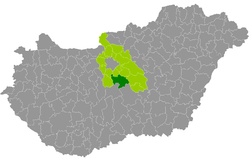
 Dabas District within Hungary and Pest County. | |
| Country | |
| County | Pest |
| District seat | Dabas |
| Area | |
• Total | 614.23 km2 (237.16 sq mi) |
| • Rank | 3rd in Pest |
| Population (2011 census) | |
• Total | 48,289 |
| • Rank | 12th in Pest |
| • Density | 79/km2 (200/sq mi) |
Dabas (Hungarian: Dabasi járás) is a district in southern part of Pest County. Dabas is also the name of the town where the district seat is found. The district is located in the Central Hungary Statistical Region.
Geography
[edit]Dabas District borders with Gyál District and Monor District to the north, Cegléd District to the east, Kecskemét District and Kunszentmiklós District (Bács-Kiskun County) to the south, Ráckeve District and Szigetszentmiklós District to the west. The number of the inhabited places in Dabas District is 11.
Municipalities
[edit]The district has 3 towns, 2 large villages and 6 villages. (ordered by population, as of 1 January 2013)[1]
- Bugyi (5,160)
- Dabas (16,506) – district seat
- Hernád (4,111)
- Inárcs (4,407)
- Kakucs (2,747)
- Örkény (4,836)
- Pusztavacs (1,367)
- Táborfalva (3,363)
- Tatárszentgyörgy (1,870)
- Újhartyán (2,707)
- Újlengyel (1,672)
The bolded municipalities are cities, italics municipalities are large villages.
Demographics
[edit]Religion in Dabas District (2011 census)
In 2011, it had a population of 48,289 and the population density was 79/km².
| Year | County population[2] | Change |
|---|---|---|
| 2011 | 48,289 | n/a |
Ethnicity
[edit]Besides the Hungarian majority, the main minorities are the Roma (approx. 2,100), German (1,400), Slovak (1,200) and Romanian (300).
Total population (2011 census): 48,289
Ethnic groups (2011 census):[3] Identified themselves: 47,774 persons:
- Hungarians: 42,305 (88.55%)
- Gypsies: 2,103 (4.40%)
- Germans: 1,391 (2.91%)
- Slovaks: 1,219 (2.55%)
- Others and indefinable: 756 (1.58%)
Approx. 500 persons in Dabas District did not declare their ethnic group at the 2011 census.
Religion
[edit]Religious adherence in the county according to 2011 census:[4]
- Catholic – 23,774 (Roman Catholic – 23,568; Greek Catholic – 203);
- Reformed – 4,579;
- Evangelical – 948;
- other religions – 715;
- Non-religious – 6,181;
- Atheism – 426;
- Undeclared – 11,668.
Gallery
[edit]-
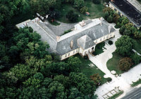
Mansion of Móric Halász in Dabas
-
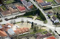
Aerial view of Újhartyán
-
Pálóczy-Horváth Mansion in Örkény
-
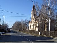
View of Kakucs
See also
[edit]References
[edit]- ^ A KSH 2013. évi helységnévkönyve
- ^ népesség.com, "Dabasi járás népessége"
- ^ 4.1.6.1 A népesség nemzetiség szerint, 2011, (in Hungarian) [1]
- ^ 4.1.7.1 A népesség vallás, felekezet szerint, 2011, (in Hungarian) [2]
External links
[edit]47°11′00″N 19°19′00″E / 47.1833°N 19.3167°E


