Lake Qadisiyah: Difference between revisions
Appearance
Content deleted Content added
Added {{unreferenced}} tag to article (TW) |
|||
| (20 intermediate revisions by 13 users not shown) | |||
| Line 1: | Line 1: | ||
{{short description|Lake in Al Anbar, Iraq}} |
|||
{{unreferenced|date=September 2014}} |
|||
{{Infobox body of water |
|||
| ⚫ | |||
| name = Lake Qadisiyah |
|||
| native_name = |
|||
| native_name_lang = |
|||
| other_name = |
|||
<!-- Images --> |
|||
| image = ISS-45 StoryOfWater, Colors Patiently Swirl - Haditha Dam Lake.jpg |
|||
| alt = |
|||
| caption = Lake Qadisiyah, as seen from the [[International Space Station]] |
|||
| image_bathymetry = |
|||
| alt_bathymetry = |
|||
| caption_bathymetry = |
|||
<!-- Stats --> |
|||
| location = [[Al-Anbar]], [[Iraq]] |
|||
| group = |
|||
| ⚫ | |||
| type = [[reservoir]] |
|||
| etymology = |
|||
| part_of = |
|||
| inflow = |
|||
| rivers = |
|||
| outflow = |
|||
| oceans = |
|||
| catchment = <!-- {{convert|VALUE|UNITS}} must be used --> |
|||
| basin_countries = |
|||
| agency = |
|||
| designation = |
|||
| date-built = <!-- {{Start date|YYYY|MM|DD}} For man-made and other recent bodies of water --> |
|||
| engineer = |
|||
| date-flooded = <!-- {{Start date|YYYY|MM|DD}} For man-made and other recent bodies of water --> |
|||
| length = <!-- {{convert|VALUE|UNITS}} must be used --> |
|||
| width = <!-- {{convert|VALUE|UNITS}} must be used --> |
|||
| area = <!-- {{convert|VALUE|UNITS}} must be used --> |
|||
| depth = <!-- {{convert|VALUE|UNITS}} must be used --> |
|||
| max-depth = <!-- {{convert|VALUE|UNITS}} must be used --> |
|||
| volume = <!-- {{convert|VALUE|UNITS}} must be used --> |
|||
| residence_time = |
|||
| salinity = |
|||
| shore = {{convert|100|km}}<!-- {{convert|VALUE|UNITS}} must be used --> |
|||
| elevation = <!-- {{convert|VALUE|UNITS}} must be used --> |
|||
| temperature_high = <!-- {{convert|VALUE|UNITS}} must be used --> |
|||
| temperature_low = <!-- {{convert|VALUE|UNITS}} must be used --> |
|||
| frozen = |
|||
| islands = |
|||
| islands_category = |
|||
| sections = |
|||
| trenches = |
|||
| benches = |
|||
| cities = |
|||
<!-- Map --> |
|||
| pushpin_map = Iraq |
|||
| pushpin_label_position = |
|||
| pushpin_map_alt = Location of Lake Qadisiyah in Iraq. |
|||
| pushpin_map_caption = |
|||
<!-- Below --> |
|||
| website = |
|||
| reference = |
|||
}} |
|||
| ⚫ | |||
| ⚫ | |||
[[Image: US_Navy_boat_on_Lake_Qadisiyah_Iraq.jpg|thumb|right|400px|US Navy boat patrolling Lake Qadisiyah near Haditha, Iraq in 2008]] |
|||
| ⚫ | |||
| ⚫ | |||
| ⚫ | On December 3, 2006, it was the site of an emergency landing by an American [[CH-46E Sea Knight]] helicopter from the [[3rd Marine Aircraft Wing]] that resulted in the drowning deaths of four out of its sixteen passengers.<ref>{{Cite web|url=http://www.popasmoke.com/kia/incidents.php?incident_id=318&conflict_id=|title = Pop a Smoke}}</ref> |
||
==See also== |
|||
*[[Lake Tharthar]] |
|||
*[[Lake Habbaniyah]] |
|||
*[[Lake Milh]] |
|||
*[[Mosul Dam]] |
|||
*[[List of dams and reservoirs in Iraq]] |
|||
*[[Wildlife of Iraq]] |
|||
==References== |
==References== |
||
<references /> |
<references /> |
||
| ⚫ | |||
| ⚫ | |||
{{DEFAULTSORT:Qadisiyah}} |
|||
[[Category:Reservoirs in Iraq]] |
[[Category:Reservoirs in Iraq]] |
||
[[Category:Lakes of Iraq]] |
[[Category:Lakes of Iraq]] |
||
| ⚫ | |||
Latest revision as of 19:10, 20 October 2024
| Lake Qadisiyah | |
|---|---|
 Lake Qadisiyah, as seen from the International Space Station | |
| Location | Al-Anbar, Iraq |
| Coordinates | 34°18′32″N 42°14′20″E / 34.30889°N 42.23889°E |
| Type | reservoir |
| Shore length1 | 100 kilometres (62 mi) |
| 1 Shore length is not a well-defined measure. | |
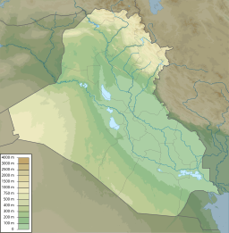
A man-made reservoir in Al-Anbar, Iraq, Lake Qadisiyah (Arabic: بحيرة القادسية) sits on the north side of the Haditha Dam.
Qadisiyah was formed by the damming of the Euphrates river above Haditha, Iraq. It has 100 kilometres (62 mi) of shoreline and provides irrigation water for nearby cultivated fields.
On December 3, 2006, it was the site of an emergency landing by an American CH-46E Sea Knight helicopter from the 3rd Marine Aircraft Wing that resulted in the drowning deaths of four out of its sixteen passengers.[1]
See also
[edit]- Lake Tharthar
- Lake Habbaniyah
- Lake Milh
- Mosul Dam
- List of dams and reservoirs in Iraq
- Wildlife of Iraq
References
[edit]

