Długa Kościelna: Difference between revisions
Appearance
Content deleted Content added
m →References: WP:CHECKWIKI error fixes / special characters in sortkey fixed using AWB (9427) |
m →top: Format administrative division links, remove DEFAULTSORTKEY as per WP:SORTKEY, remove One Source for stubs, minor formatting changes (AWB) |
||
| (5 intermediate revisions by 4 users not shown) | |||
| Line 3: | Line 3: | ||
| settlement_type = Village |
| settlement_type = Village |
||
| total_type = |
| total_type = |
||
| image_skyline = |
| image_skyline = Długa Kościelna 1.jpg |
||
| image_caption = |
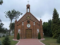
| image_caption = Blessed Sacrament church in Długa Kościelna |
||
| ⚫ | |||
| image_flag = |
|||
| ⚫ | |||
| image_shield = |
|||
| image_map = |
|||
| coordinates_region = PL |
|||
| ⚫ | |||
| ⚫ | |||
| subdivision_type1 = [[Voivodeships of Poland|Voivodeship]] |
| subdivision_type1 = [[Voivodeships of Poland|Voivodeship]] |
||
| subdivision_name1 = [[Masovian Voivodeship|Masovian]] |
| subdivision_name1 = [[Masovian Voivodeship|Masovian]] |
||
| Line 17: | Line 13: | ||
| subdivision_type3 = [[Gmina]] |
| subdivision_type3 = [[Gmina]] |
||
| subdivision_name3 = [[Gmina Halinów|Halinów]] |
| subdivision_name3 = [[Gmina Halinów|Halinów]] |
||
| ⚫ | |||
| latd = 52 |
|||
| latm = 14 |
|||
| lats = |
|||
| latNS = N |
|||
| longd = 21 |
|||
| longm = 21 |
|||
| longs = |
|||
| longEW = E |
|||
| pushpin_map = Poland |
| pushpin_map = Poland |
||
| pushpin_label_position = bottom |
| pushpin_label_position = bottom |
||
| timezone = [[Central European Time|CET]] |
|||
| ⚫ | |||
| utc_offset = +1 |
|||
| timezone_DST = [[Central European Summer Time|CEST]] |
|||
| utc_offset_DST = +2 |
|||
| ⚫ | |||
| population_total = 723 |
| population_total = 723 |
||
| registration_plate = WM |
|||
| website = }} |
|||
}} |
|||
'''Długa Kościelna''' {{IPAc-pl|'|d|ł|u|g|a|-|k|o|ś|'|ć|e1|l|n|a}} is a [[village]] in the administrative district of [[Gmina Halinów]], within [[Mińsk County]], [[Masovian Voivodeship]], in east-central Poland.<ref name="TERYT">{{cite web |url=http://www.stat.gov.pl/broker/access/prefile/listPreFiles.jspa |title=Central Statistical Office (GUS) - TERYT (National Register of Territorial Land Apportionment Journal) |date=2008-06-01 |language=Polish}}</ref> It lies approximately |
'''Długa Kościelna''' {{IPAc-pl|'|d|ł|u|g|a|-|k|o|ś|'|ć|e1|l|n|a}} is a [[village]] in the administrative district of [[Gmina Halinów]], within [[Mińsk County]], [[Masovian Voivodeship]], in east-central Poland.<ref name="TERYT">{{cite web |url=http://www.stat.gov.pl/broker/access/prefile/listPreFiles.jspa |title=Central Statistical Office (GUS) - TERYT (National Register of Territorial Land Apportionment Journal) |date=2008-06-01 |language=Polish}}</ref> It borders the town of [[Halinów]] in the south and lies approximately {{convert|16|km|mi|0|abbr=on}} west of [[Mińsk Mazowiecki]] and {{convert|24|km|mi|0|abbr=on}} east of [[Warsaw]]. |
||
There are two churches and parishes in the village: the [[Catholic]] Saint Anne church and the [[Catholic Mariavite Church|Catholic Mariavite]] Blessed Sacrament church. |
|||
The village has a population of 723. |
|||
==References== |
==References== |
||
{{reflist}} |
{{reflist}} |
||
<br> |
|||
{{Gmina Halinów}} |
{{Gmina Halinów}} |
||
| ⚫ | |||
{{DEFAULTSORT:Dluga Koscielna}} |
|||
[[Category:Villages in Mińsk County]] |
[[Category:Villages in Mińsk County]] |
||
Latest revision as of 08:24, 21 October 2024
Długa Kościelna | |
|---|---|
Village | |
 Blessed Sacrament church in Długa Kościelna | |
| Coordinates: 52°14′N 21°21′E / 52.233°N 21.350°E | |
| Country | |
| Voivodeship | Masovian |
| County | Mińsk |
| Gmina | Halinów |
| Population | 723 |
| Time zone | UTC+1 (CET) |
| • Summer (DST) | UTC+2 (CEST) |
| Vehicle registration | WM |
Długa Kościelna [ˈdwuɡa kɔɕˈt͡ɕɛlna] is a village in the administrative district of Gmina Halinów, within Mińsk County, Masovian Voivodeship, in east-central Poland.[1] It borders the town of Halinów in the south and lies approximately 16 km (10 mi) west of Mińsk Mazowiecki and 24 km (15 mi) east of Warsaw.
There are two churches and parishes in the village: the Catholic Saint Anne church and the Catholic Mariavite Blessed Sacrament church.
References
[edit]


