Volyně: Difference between revisions
| Line 54: | Line 54: | ||
| footnotes = |
| footnotes = |
||
}} |
}} |
||
'''Volyně''' ({{ |
'''Volyně''' ({{langx|de|Wolin}}) is a town in [[Strakonice District]] in the [[South Bohemian Region]] of the [[Czech Republic]]. It has about 3,000 inhabitants. The historic town centre is well preserved and is protected by law as an [[Cultural monument (Czech Republic)#Monument zones|urban monument zone]]. |
||
==Administrative parts== |
==Administrative parts== |
||
Latest revision as of 22:06, 23 October 2024
Volyně | |
|---|---|
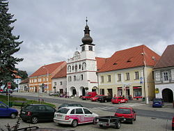
 Town square | |
| Coordinates: 49°9′57″N 13°53′10″E / 49.16583°N 13.88611°E | |
| Country | |
| Region | South Bohemian |
| District | Strakonice |
| First mentioned | 1271 |
| Government | |
| • Mayor | Martin Červený |
| Area | |
• Total | 20.58 km2 (7.95 sq mi) |
| Elevation | 461 m (1,512 ft) |
| Population (2024-01-01)[1] | |
• Total | 2,988 |
| • Density | 150/km2 (380/sq mi) |
| Time zone | UTC+1 (CET) |
| • Summer (DST) | UTC+2 (CEST) |
| Postal code | 387 01 |
| Website | www |
Volyně (German: Wolin) is a town in Strakonice District in the South Bohemian Region of the Czech Republic. It has about 3,000 inhabitants. The historic town centre is well preserved and is protected by law as an urban monument zone.
Administrative parts
[edit]The villages of Černětice, Račí, Starov and Zechovice are administrative parts of Volyně. Černětice and Račí form an exclave of the municipal territory.
Etymology
[edit]The origin of the name Volyně is unknown. There are hypotheses that it was derived from a Slavic tribe which came from the area of today's Ukraine.[2]
Geography
[edit]Volyně is located about 10 kilometres (6 mi) south of Strakonice and 46 km (29 mi) northwest of České Budějovice. It lies in the Bohemian Forest Foothills. The highest point is a nameless hill at 769 metres (2,523 ft) above sea level. The Volyňka River flows through the town.
History
[edit]According to archaeological findings, a Slavic settlement was built on the site of today's town in the 7th century. The first written mention of Volyně is from 1271, when a gord was documented here. In 1299, the settlement was promoted to a town. In 1327, the parish church and town fortifications were completed. In the 15th century, the Volyně waged a long-standing and ultimately victorious dispute with the royal town of Písek over the import of salt and the payment of tolls. The town's prosperity peaked before the Thirty Years' War.[2]
During the war, Volyně suffered from looting, fires and passage of troops. After the war, despite several fires and plague epidemics, the town continued to grow and spread beyond the town walls. The face of the town changed significantly in the 19th century, when the square was paved and new multi-story buildings began to be built.[2]
Demographics
[edit]
|
|
| ||||||||||||||||||||||||||||||||||||||||||||||||||||||
| Source: Censuses[3][4] | ||||||||||||||||||||||||||||||||||||||||||||||||||||||||
Education
[edit]The town is known as a local centre of education. Apart from preschool education and a primary/secondary school, there is Higher Vocational School and Secondary Industrial School. It was founded in 1864.[5]
Transport
[edit]The I/4 road (the section from Strakonice to the Czech-German border in Strážný) passes through the town.
Volyně is located on the railway line Strakonice–Volary.
Sights
[edit]
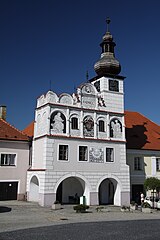
The historic town centre is formed by Svobody Square and adjacent streets. The main landmark of the square is the Renaissance town hall, built between 1521 and 1529. Other historical buildings include Gothic fortress from the 14th century, Church of All Saints from same period, Church of the Transfiguration, which was built between 1580 and 1618, and Jewish synagogue that dates from 1939. A Marian column located in the middle of the town square dates from 1760.[2][6]
Notable people
[edit]- Josef Niklas (1817–1877), architect
- Josef Kaizl (1854–1901), economist and politician
- Jan Rubeš (1920–2009), opera singer and actor
Twin towns – sister cities
[edit]References
[edit]- ^ "Population of Municipalities – 1 January 2024". Czech Statistical Office. 2024-05-17.
- ^ a b c d "Historie" (in Czech). Město Volyně. Retrieved 2022-08-28.
- ^ "Historický lexikon obcí České republiky 1869–2011" (in Czech). Czech Statistical Office. 2015-12-21.
- ^ "Population Census 2021: Population by sex". Public Database. Czech Statistical Office. 2021-03-27.
- ^ "Historie školy" (in Czech). Vyšší odborná škola a Střední průmyslová škola Volyně. Retrieved 2021-08-22.
- ^ "Basic City Info". Volyně.info. Retrieved 2022-08-28.
- ^ "Partneři v zahraničí" (in Czech). Město Volyně. Retrieved 2020-08-24.


