Lake Biel: Difference between revisions
| (46 intermediate revisions by 29 users not shown) | |||
| Line 1: | Line 1: | ||
{{Short description|Lake in western Switzerland}} |
|||
| ⚫ | |||
__NOTOC__ |
|||
| ⚫ | |||
| ⚫ | |||
|image = Bielersee.jpg |
|||
| ⚫ | |||
| ⚫ | |||
| other_name = '''Lake Bienne'''<br/>{{native name|de|Bielersee}}<br/>{{native name|fr|Lac de Bienne}} |
|||
| ⚫ | |||
| image = Lake Biel sentinel-2.jpg |
|||
| ⚫ | |||
| ⚫ | |||
| ⚫ | |||
| ⚫ | |||
| ⚫ | |||
| ⚫ | |||
| ⚫ | |||
| ⚫ | |||
| ⚫ | |||
| ⚫ | |||
| ⚫ | |||
| ⚫ | |||
| ⚫ | |||
| ⚫ | |||
| ⚫ | |||
| ⚫ | |||
|length = 15 km |
|||
| ⚫ | |||
|width = 4.1 km |
|||
| ⚫ | |||
|area = [[1 E7 m²|39.3 km²]] |
|||
| length = {{convert|15|km|abbr=on}} |
|||
| ⚫ | |||
| width = {{convert|4.1|km|abbr=on}} |
|||
| ⚫ | |||
| area = {{convert|39.3|km2|abbr=on}} |
|||
|volume = 1.12 km³ |
|||
| ⚫ | |||
| ⚫ | |||
| ⚫ | |||
| ⚫ | |||
| volume = {{convert|1.12|km3|acre.ft|abbr=on}} |
|||
| ⚫ | |||
| ⚫ | |||
| ⚫ | |||
| ⚫ | |||
| ⚫ | |||
| ⚫ | |||
| ⚫ | |||
| ⚫ | |||
| pushpin_map=Canton of Bern#Canton of Neuchâtel#Switzerland#Alps |
|||
| pushpin_label_position= bottom |
|||
| embedded = {{Infobox mapframe |wikidata=yes |zoom=11 |coord={{WikidataCoord|display=i}}}} |
|||
}} |
}} |
||
'''Lake Biel''' or '''Lake Bienne''' ( |
'''Lake Biel''' or '''Lake Bienne''' ({{langx|de|Bielersee}}; {{langx|fr|Lac de Bienne}} {{IPA|fr|lak də bjɛn|}}) is a [[lake]] in western [[Switzerland]]. Together with [[Lake Murten|Lake Morat]] and [[Lake Neuchâtel]], it is one of the three large lakes in the [[Jura mountains|Jura]] region of Switzerland. It lies on the language boundary between German and French speaking areas. |
||
== Geography == |
|||
The lake is 15 km long and up to 4.1 km wide. Its surface area is [[1 E7 |
The lake is 15 km long and up to 4.1 km wide. Its surface area is [[1 E7 m2|39.3 km<sup>2</sup>]], the maximum depth 74 m. The lake is located at 429 metres above sea level. |
||
Lake Biel has a catchment area of about [[1 E9 |
Lake Biel/Bienne has a catchment area of about [[1 E9 m2|8,305 km<sup>2</sup>]]. Water remains in the lake for an average of 58 days. The rivers [[Aare]] and [[Zihl]]/[[Thielle]] flowing from Lake Neuchâtel, the [[Twannbach]] draining water down from the surplombing first Jura mountain range and the [[Suze (river)|Suze]] draining water down from the [[Vallon de St. Imier]], are the main tributaries. The [[Aare]] was redirected into the lake in 1878, in order to prevent the flooding of the nearby area called "Seeland", and drains the water out of the lake down to [[Büren, Solothurn|Büren]] through a simultaneously man-made channel. The level of all three lakes is being controlled by a dam built across the channel, in [[Port (Bern)|Port]]. |
||
The largest settlement along the shores of Lake Biel are the [[bilingual]] city of [[Biel/Bienne]] and its sister city [[Nidau]], both located on the northern end |
The largest settlement along the shores of Lake Biel are the [[bilingual]] city of [[Biel/Bienne]] and its sister city [[Nidau]], both located on the northern end. The [[St. Peter's Island]] attracts tourists. The island is located near [[Erlach, Switzerland|Erlach/Cerlier]]. [[Jean-Jacques Rousseau]] once spent a few months on the island. |
||
One of the main business in the area is the watch and affiliated microtechnic industries. World famous watch brands have their sites and headquarters in the area, including the [[Swatch Group]] and [[Rolex]] movements manufacture. |
One of the main business in the area is the watch and affiliated microtechnic industries. World famous watch brands have their sites and headquarters in the area, including the [[Swatch Group]] and [[Rolex]] movements manufacture. |
||
| Line 36: | Line 43: | ||
The lake's surface is the [[List of cantons of Switzerland by elevation|lowest point]] of the canton of Neuchâtel. |
The lake's surface is the [[List of cantons of Switzerland by elevation|lowest point]] of the canton of Neuchâtel. |
||
== |
== Towns and villages by the lake == |
||
[[ |
[[File:Swiss-bienne-city-1.JPG|thumb|The lake at Alfermée with the view of [[Biel/Bienne]] and [[Nidau]]]] |
||
As the lake is located on the border of the French and German language regions, most places have names in both languages, though not all versions are still in use. |
As the lake is located on the border of the French and German language regions, most places have names in both languages, though not all versions are still in use. |
||
*Alfermée |
|||
*Bipschal - Bévesier |
*Bipschal - Bévesier |
||
*[[Erlach BE|Erlach]] - Cerlier |
*[[Erlach BE|Erlach]] - Cerlier |
||
*Gaicht - Jugy |
*Gaicht - Jugy |
||
* |
*Gerolfingen |
||
*[[Hagneck]] |
*[[Hagneck]] |
||
*Im Rusel |
|||
*[[Ipsach]] |
*[[Ipsach]] |
||
* |
*[[Le Landeron]] ([[canton of Neuchâtel]]) - Landern |
||
*[[Ligerz]] - Gléresse |
*[[Ligerz]] - Gléresse |
||
*[[Lüscherz]] - Locras |
*[[Lüscherz]] - Locras |
||
| Line 52: | Line 61: | ||
*Neuenstadt - [[La Neuveville]] |
*Neuenstadt - [[La Neuveville]] |
||
*[[Nidau]] |
*[[Nidau]] |
||
*[[St. Petersinsel|Sankt-Petersinsel |
*[[St. Petersinsel|Sankt-Petersinsel]] |
||
*Schafis - Chavanne |
*Schafis - Chavanne |
||
*Schernelz - Cernaux |
*Schernelz - Cernaux |
||
*Sutz-Lattrigen |
*Sutz-Lattrigen |
||
*[[Täuffelen]] - |
*[[Täuffelen]] - Choufaille |
||
*[[Tüscherz-Alfermée|Tüscherz]] - Daucher |
*[[Tüscherz-Alfermée|Tüscherz]] - Daucher |
||
*[[Twann]] - Douanne |
*[[Twann]] - Douanne |
||
| Line 64: | Line 73: | ||
==External links== |
==External links== |
||
{{Commons category|Lake |
{{Commons category|Lake Biel}} |
||
*{{HDS|8646}} |
*{{HDS|8646}} |
||
*[http://www.hydrodaten.admin.ch/en/2208.html#aktuelle_daten Waterlevels of Lake Bienne] at [[Ligerz]] |
*[http://www.hydrodaten.admin.ch/en/2208.html#aktuelle_daten Waterlevels of Lake Bienne] at [[Ligerz]] |
||
*[http://www.biel-seeland.ch Tourism Biel/Bienne Seeland] |
*[http://www.biel-seeland.ch Tourism Biel/Bienne Seeland] |
||
* {{Cite EB1911|wstitle= Bienne, Lake of | volume= 3 |last= Coolidge |first= William Augustus Brevoort |author-link= W. A. B. Coolidge| page = 921 |short= 1}} |
|||
[[File:Lac de Bienne (Nidau).JPG|thumb|center| |
[[File:Lac de Bienne (Nidau).JPG|thumb|center|770px|Lake Biel, view from Nidau]] |
||
{{Lakes of Switzerland}} |
{{Lakes of Switzerland}} |
||
{{Authority control}} |
{{Authority control}} |
||
[[Category: |
[[Category:Lake Biel| ]] |
||
| ⚫ | |||
[[Category:Lakes of the canton of Bern|Biel]] |
[[Category:Lakes of the canton of Bern|Biel]] |
||
[[Category:Lakes of the canton of Neuchâtel|Biel]] |
[[Category:Lakes of the canton of Neuchâtel|Biel]] |
||
[[Category:Aare |
[[Category:Aare basin|LBiel]] |
||
[[Category:Bern–Neuchâtel border]] |
[[Category:Bern–Neuchâtel border]] |
||
| ⚫ | |||
Latest revision as of 01:11, 24 October 2024
| Lake Biel | |
|---|---|
| Lake Bienne Bielersee (German) Lac de Bienne (French) | |
 | |
| Location | Canton of Bern |
| Coordinates | 47°5′N 7°10′E / 47.083°N 7.167°E |
| Catchment area | 8,305 km2 (3,207 sq mi) |
| Basin countries | Switzerland |
| Max. length | 15 km (9.3 mi) |
| Max. width | 4.1 km (2.5 mi) |
| Surface area | 39.3 km2 (15.2 sq mi) |
| Max. depth | 74 m (243 ft) |
| Water volume | 1.12 km3 (910,000 acre⋅ft) |
| Residence time | 58 days |
| Surface elevation | 429 m (1,407 ft) |
| Islands | St. Peter's Island |
| Settlements | Biel/Bienne (see list) |
 | |
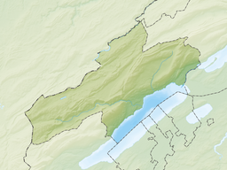
Lake Biel or Lake Bienne (German: Bielersee; French: Lac de Bienne [lak də bjɛn]) is a lake in western Switzerland. Together with Lake Morat and Lake Neuchâtel, it is one of the three large lakes in the Jura region of Switzerland. It lies on the language boundary between German and French speaking areas.
Geography
[edit]The lake is 15 km long and up to 4.1 km wide. Its surface area is 39.3 km2, the maximum depth 74 m. The lake is located at 429 metres above sea level.
Lake Biel/Bienne has a catchment area of about 8,305 km2. Water remains in the lake for an average of 58 days. The rivers Aare and Zihl/Thielle flowing from Lake Neuchâtel, the Twannbach draining water down from the surplombing first Jura mountain range and the Suze draining water down from the Vallon de St. Imier, are the main tributaries. The Aare was redirected into the lake in 1878, in order to prevent the flooding of the nearby area called "Seeland", and drains the water out of the lake down to Büren through a simultaneously man-made channel. The level of all three lakes is being controlled by a dam built across the channel, in Port.
The largest settlement along the shores of Lake Biel are the bilingual city of Biel/Bienne and its sister city Nidau, both located on the northern end. The St. Peter's Island attracts tourists. The island is located near Erlach/Cerlier. Jean-Jacques Rousseau once spent a few months on the island.
One of the main business in the area is the watch and affiliated microtechnic industries. World famous watch brands have their sites and headquarters in the area, including the Swatch Group and Rolex movements manufacture.
The lake's surface is the lowest point of the canton of Neuchâtel.
Towns and villages by the lake
[edit]
As the lake is located on the border of the French and German language regions, most places have names in both languages, though not all versions are still in use.
- Alfermée
- Bipschal - Bévesier
- Erlach - Cerlier
- Gaicht - Jugy
- Gerolfingen
- Hagneck
- Im Rusel
- Ipsach
- Le Landeron (canton of Neuchâtel) - Landern
- Ligerz - Gléresse
- Lüscherz - Locras
- Mörigen - Morenges
- Neuenstadt - La Neuveville
- Nidau
- Sankt-Petersinsel
- Schafis - Chavanne
- Schernelz - Cernaux
- Sutz-Lattrigen
- Täuffelen - Choufaille
- Tüscherz - Daucher
- Twann - Douanne
- Vinelz - Fénil
- Vingelz - Vigneules
- Wingreis - Vingras
External links
[edit]- Lake Biel in German, French and Italian in the online Historical Dictionary of Switzerland.
- Waterlevels of Lake Bienne at Ligerz
- Tourism Biel/Bienne Seeland
- Coolidge, William Augustus Brevoort (1911). . Encyclopædia Britannica. Vol. 3 (11th ed.). p. 921.


