Dnestrovsc: Difference between revisions
Infobox |
m Task 20: replace {lang-??} templates with {langx|??} ‹See Tfd› (Replaced 3; skipped unknown 1: Lang-mo-Cyrl); |
||
| (35 intermediate revisions by 22 users not shown) | |||
| Line 1: | Line 1: | ||
{{Expand Russian|topic=geo}} |
|||
{{Infobox settlement |
{{Infobox settlement |
||
| name = Dnestrovsc |
| name = Dnestrovsc |
||
| other_name = Днестро́вск<br />Дністро́вськ |
| other_name = Днестро́вск<br />Дністро́вськ |
||
| settlement_type = [[list of cities in Moldova|Town]] |
| settlement_type = [[list of cities in Moldova|Town]] |
||
| image_skyline |
| image_skyline = Dnestrovsc, Moldova - panoramio.jpg |
||
| image_flag = Flag of Dnestrovsc.png |
| image_flag = Flag of Dnestrovsc.png |
||
| image_shield = Dnestrovsk gerb.gif |
| image_shield = Dnestrovsk gerb.gif |
||
| pushpin_map =Moldova |
| pushpin_map = Moldova |
||
| pushpin_label_position = |
| pushpin_label_position = |
||
| pushpin_map_caption = Location of Dnestrovsc in [[Moldova]] |
| pushpin_map_caption = Location of Dnestrovsc in [[Moldova]] |
||
| subdivision_type |
| subdivision_type = [[List of sovereign states|Country]] (''de jure'') |
||
| subdivision_name |
| subdivision_name = {{flag|Moldova}} |
||
| subdivision_type1 |
| subdivision_type1 = Country (''de facto'') |
||
| subdivision_name1 |
| subdivision_name1 = {{flag|Transnistria}}{{efn|{{Transnistria-note}}}} |
||
| coordinates = {{coord|46|37|20|N|29|54|38|E|display=inline}} |
|||
| latd = 46 | latm = 37 | lats = 20 | latNS = N |
|||
| ⚫ | |||
| longd = 29 | longm = 54 | longs = 38 |longEW=E |
|||
| ⚫ | |||
| ⚫ | |||
| ⚫ | |||
| ⚫ | |||
| blank_name = [[Köppen climate classification|Climate]] |
|||
| ⚫ | |||
| blank_info = [[Oceanic climate|Cfb]] |
|||
| module = {{Infobox mapframe |wikidata=yes |zoom=11 |frame-height=300 | stroke-width=1 |shape-fill-opacity=0.2 |coord={{WikidataCoord|display=i}}}} |
|||
| Mayor = |
|||
| leader_title1 = Mayor |
|||
| leader_name1 = [[Oleg Dovgopol]] |
|||
}} |
}} |
||
'''Dnestrovsc''' ({{ |
'''Dnestrovsc''' ({{langx|ro|Dnestrovsc}} or {{lang|ro|Nistrovsc}}, {{lang-mo-Cyrl|Днестровск}}; {{langx|ru|Днестрóвск|Dnestrovsk}}; {{langx|uk|Дністровськ|Dnistrovs'k}}) is a town in southern [[Moldova]], near the border with [[Ukraine]]. It is at the shores of the [[Cuciurgan Reservoir]] and is home to the [[Cuciurgan power station]], also known as ''Moldavskaya GRES''. It has since 1990 been administered by the breakaway [[Transnistrian Moldovan Republic]] as a part of its [[Slobozia District]]. |
||
It is a [[company town]] which was founded in early [[Soviet Union|Soviet]] times by the establishment of a large power plant, Moldavskaya GRES, today owned by Inter RAO UES. |
It is a [[company town]] which was founded in early [[Soviet Union|Soviet]] times by the establishment of a large power plant, Moldavskaya GRES, today owned by Inter RAO UES. |
||
At the 1989 census, Dnestrovsc |
At the 1989 census, Dnestrovsc had a population of 14,876. At the 2004 census it had ca. 11,200 inhabitants. According to the 2004 census, the population of the town was 12,382 inhabitants, of which 2,580 (20.83%) were Moldovans (Romanians), 3,390 (27.37%) Ukrainians and 5,249 (42.39%) Russians.<ref>The Transnistrian census of 2004 data by nationality at http://pop-stat.mashke.org/pmr-ethnic-loc2004.htm </ref> |
||
==Notes== |
|||
{{notelist}} |
|||
== References == |
|||
{{reflist}} |
|||
{{Transnistria, Moldova}} |
{{Transnistria, Moldova}} |
||
| Line 30: | Line 43: | ||
{{coord|46|37|N|29|55|E|display=title|region:MD_type:city_source:GNS-enwiki}} |
{{coord|46|37|N|29|55|E|display=title|region:MD_type:city_source:GNS-enwiki}} |
||
[[Category:Cities in Transnistria]] |
[[Category:Cities and towns in Transnistria]] |
||
[[Category:Cities in Moldova]] |
[[Category:Cities and towns in Moldova]] |
||
[[Category:Slobozia District]] |
|||
Latest revision as of 09:11, 24 October 2024
You can help expand this article with text translated from the corresponding article in Russian. Click [show] for important translation instructions.
|
Dnestrovsc
Днестро́вск Дністро́вськ | |
|---|---|
 | |
Location of Dnestrovsc in Moldova | |
| Coordinates: 46°37′20″N 29°54′38″E / 46.62222°N 29.91056°E | |
| Country (de jure) | |
| Country (de facto) | |
| Government | |
| • Mayor | Oleg Dovgopol |
| Elevation | 19 m (62 ft) |
| Population (2014) | |
• Total | 10,436 |
| Climate | Cfb |
 | |
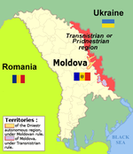
Dnestrovsc (Romanian: Dnestrovsc or Nistrovsc, Moldovan Cyrillic: Днестровск; Russian: Днестрóвск, romanized: Dnestrovsk; Ukrainian: Дністровськ, romanized: Dnistrovs'k) is a town in southern Moldova, near the border with Ukraine. It is at the shores of the Cuciurgan Reservoir and is home to the Cuciurgan power station, also known as Moldavskaya GRES. It has since 1990 been administered by the breakaway Transnistrian Moldovan Republic as a part of its Slobozia District.
It is a company town which was founded in early Soviet times by the establishment of a large power plant, Moldavskaya GRES, today owned by Inter RAO UES.
At the 1989 census, Dnestrovsc had a population of 14,876. At the 2004 census it had ca. 11,200 inhabitants. According to the 2004 census, the population of the town was 12,382 inhabitants, of which 2,580 (20.83%) were Moldovans (Romanians), 3,390 (27.37%) Ukrainians and 5,249 (42.39%) Russians.[1]
Notes
[edit]- ^ Transnistria's political status is disputed. It considers itself to be an independent state, but this is not recognised by any UN member state. The Moldovan government and the international community consider Transnistria a part of Moldova's territory.
References
[edit]- ^ The Transnistrian census of 2004 data by nationality at http://pop-stat.mashke.org/pmr-ethnic-loc2004.htm
46°37′N 29°55′E / 46.617°N 29.917°E


