Phipun district: Difference between revisions
m fixed CS1 errors: dates & General fixes using AWB (9816) |
|||
| (17 intermediate revisions by 13 users not shown) | |||
| Line 3: | Line 3: | ||
| native_name = พิปูน |
| native_name = พิปูน |
||
| native_name_lang= th |
| native_name_lang= th |
||
| settlement_type = [[ |
| settlement_type = [[District]] |
||
| image_skyline = |
| image_skyline = |
||
| image_alt = |
| image_alt = |
||
| image_caption = |
| image_caption = |
||
| image_map = Amphoe 8005. |
| image_map = Amphoe 8005.svg |
||
| map_caption = |
| map_caption = District location in [[Nakhon Si Thammarat province]] |
||
| pushpin_map = |
| pushpin_map = |
||
| pushpin_map_caption = |
| pushpin_map_caption = |
||
| subdivision_type = [[Country]] |
| subdivision_type = [[Country]] |
||
| subdivision_name = |
| subdivision_name = Thailand |
||
| subdivision_type1 = [[Provinces of Thailand|Province]] |
| subdivision_type1 = [[Provinces of Thailand|Province]] |
||
| subdivision_name1 = [[Nakhon Si Thammarat Province|Nakhon Si Thammarat]] |
| subdivision_name1 = [[Nakhon Si Thammarat Province|Nakhon Si Thammarat]] |
||
| subdivision_type2 = Seat |
| subdivision_type2 = Seat |
||
| subdivision_name2 = Phipun |
| subdivision_name2 = Phipun |
||
| subdivision_type3 = |
| subdivision_type3 = [[Subdistrict]] |
||
| subdivision_name3 = |
| subdivision_name3 = |
||
| subdivision_type4 = ''[[Muban]]'' |
| subdivision_type4 = ''[[Muban]]'' |
||
| subdivision_name4 = |
| subdivision_name4 = |
||
| established_title = |
| established_title = District established |
||
| established_date = |
| established_date = |
||
| population_total = 27578 |
| population_total = 27578 |
||
| Line 33: | Line 33: | ||
| blank_name_sec2 = [[Geocode]] |
| blank_name_sec2 = [[Geocode]] |
||
| blank_info_sec2 = 8005 |
| blank_info_sec2 = 8005 |
||
| timezone = [[Time in Thailand| |
| timezone = [[Time in Thailand|ICT]] |
||
| utc_offset = +7 |
| utc_offset = +7 |
||
| coordinates = {{coord|8|33|36|N|99|36|30|E|type:adm2nd_region:TH|display=inline,title}} |
|||
| latd=8 |latm=33 |lats=36 |latNS=N |
|||
| longd=99 |longm=36 |longs=30 |longEW=E |
|||
| coordinates_type = type:adm2nd_region:TH |
|||
| coordinates_display = inline,title |
|||
| website = |
| website = |
||
| footnotes = |
| footnotes = |
||
}} |
}} |
||
'''Phipun''' ({{ |
'''Phipun''' ({{langx|th|พิปูน}}, {{IPA|th|pʰí.pūːn|pron}}) is a district (''[[amphoe]]'') in the northern part of [[Nakhon Si Thammarat province]], [[southern Thailand]]. |
||
==Geography== |
==Geography== |
||
Neighboring districts are (from the northeast clockwise) [[ |
Neighboring districts are (from the northeast clockwise): [[Nopphitam district|Nopphitam]], [[Phrom Khiri district|Phrom Khiri]], [[Lan Saka district|Lan Saka]], and [[Chawang district|Chawang]] of Nakhon Si Thammarat Province; [[Wiang Sa District, Surat Thani|Wiang Sa]] and [[Ban Na San district|Ban Na San]] of [[Surat Thani province]]. |
||
==History== |
==History== |
||
The minor district (''[[ |
The minor district (''[[king amphoe]]'') was created on 1 September 1972, when the two ''tambons'' Phipun and Kathun were split off from [[Chawang district]].<ref>{{cite journal|journal=Royal Gazette|volume=89|issue=130 ง|pages=2187|script-title=th:ประกาศกระทรวงมหาดไทย เรื่อง แบ่งท้องที่อำเภอฉวาง จังหวัดนครศรีธรรมราช ตั้งเป็นกิ่งอำเภอพิปูน|url=http://www.ratchakitcha.soc.go.th/DATA/PDF/2515/D/130/2187.PDF|archive-url=https://web.archive.org/web/20120309160632/http://www.ratchakitcha.soc.go.th/DATA/PDF/2515/D/130/2187.PDF|url-status=dead|archive-date=March 9, 2012|date=August 29, 1972|language=Thai}}</ref> It was upgraded to a full district on 8 September 1976.<ref>{{cite journal|journal=Royal Gazette|volume=93|issue=109 ก special<!--ฉบับพิเศษ-->|pages=31–34|script-title=th:พระราชกฤษฎีกาตั้งอำเภอเลาขวัญ อำเภอคำม่วง อำเภอพิปูน อำเภอศรีเทพ อำเภอนาแห้ว อำเภอส่องดาว อำเภอควนกาหลง อำเภอค่ายบางระจัน อำเภอบ้านตาขุน และอำเภอกุดจับ พ.ศ. ๒๕๑๙|url=http://www.ratchakitcha.soc.go.th/DATA/PDF/2519/A/109/31.PDF|archive-url=https://web.archive.org/web/20070927192425/http://www.ratchakitcha.soc.go.th/DATA/PDF/2519/A/109/31.PDF|url-status=dead|archive-date=September 27, 2007|date=September 8, 1976|language=Thai}}</ref> |
||
==Administration== |
==Administration== |
||
The district is |
The district is divided into five sub-districts (''[[tambon]]s''), which are further subdivided into 43 villages (''[[muban]]s''). Phibun is a township (''[[thesaban tambon]]'') covering parts of ''tambon'' Phibun. There are a further five tambon administrative organizations (TAO). |
||
{| |
{| |
||
|- valign=top |
|- valign=top |
||
| Line 61: | Line 58: | ||
! Thai name |
! Thai name |
||
! Villages |
! Villages |
||
! [[Population| |
! [[Population|Pop.]] |
||
|- |
|- |
||
||1.||Phipun||พิปูน||7||5,103|| |
||1.||Phipun||พิปูน||7||5,103|| |
||
| Line 73: | Line 70: | ||
||5.||Khuan Klang||ควนกลาง||6||4,013|| |
||5.||Khuan Klang||ควนกลาง||6||4,013|| |
||
|} |
|} |
||
|| [[Image:Tambon 8005.png|150px|Map of |
|| [[Image:Tambon 8005.png|150px|Map of subdistricts]] |
||
|} |
|} |
||
==References== |
==References== |
||
{{reflist}} |
|||
<references/> |
|||
==External links== |
==External links== |
||
| Line 86: | Line 83: | ||
{{DEFAULTSORT:Phipun}} |
{{DEFAULTSORT:Phipun}} |
||
[[Category: |
[[Category:Districts of Nakhon Si Thammarat province]] |
||
{{NakhonSiThammarat-geo-stub}} |
{{NakhonSiThammarat-geo-stub}} |
||
Latest revision as of 15:54, 24 October 2024
Phipun
พิปูน | |
|---|---|
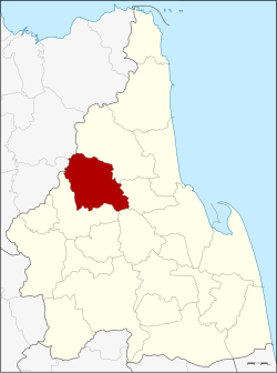
 District location in Nakhon Si Thammarat province | |
| Coordinates: 8°33′36″N 99°36′30″E / 8.56000°N 99.60833°E | |
| Country | Thailand |
| Province | Nakhon Si Thammarat |
| Seat | Phipun |
| Area | |
• Total | 363.8 km2 (140.5 sq mi) |
| Population (2005) | |
• Total | 27,578 |
| • Density | 75.8/km2 (196/sq mi) |
| Time zone | UTC+7 (ICT) |
| Postal code | 80270 |
| Geocode | 8005 |
Phipun (Thai: พิปูน, pronounced [pʰí.pūːn]) is a district (amphoe) in the northern part of Nakhon Si Thammarat province, southern Thailand.
Geography
[edit]Neighboring districts are (from the northeast clockwise): Nopphitam, Phrom Khiri, Lan Saka, and Chawang of Nakhon Si Thammarat Province; Wiang Sa and Ban Na San of Surat Thani province.
History
[edit]The minor district (king amphoe) was created on 1 September 1972, when the two tambons Phipun and Kathun were split off from Chawang district.[1] It was upgraded to a full district on 8 September 1976.[2]
Administration
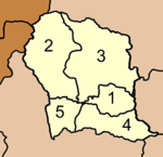
[edit]The district is divided into five sub-districts (tambons), which are further subdivided into 43 villages (mubans). Phibun is a township (thesaban tambon) covering parts of tambon Phibun. There are a further five tambon administrative organizations (TAO).
|

|
References
[edit]- ^ ประกาศกระทรวงมหาดไทย เรื่อง แบ่งท้องที่อำเภอฉวาง จังหวัดนครศรีธรรมราช ตั้งเป็นกิ่งอำเภอพิปูน (PDF). Royal Gazette (in Thai). 89 (130 ง): 2187. August 29, 1972. Archived from the original (PDF) on March 9, 2012.
- ^ พระราชกฤษฎีกาตั้งอำเภอเลาขวัญ อำเภอคำม่วง อำเภอพิปูน อำเภอศรีเทพ อำเภอนาแห้ว อำเภอส่องดาว อำเภอควนกาหลง อำเภอค่ายบางระจัน อำเภอบ้านตาขุน และอำเภอกุดจับ พ.ศ. ๒๕๑๙ (PDF). Royal Gazette (in Thai). 93 (109 ก special): 31–34. September 8, 1976. Archived from the original (PDF) on September 27, 2007.
External links
[edit]- amphoe.com (Thai)
- http://www.phipun.com Website of district (Thai)
