Lake Kerkini: Difference between revisions
→History: Rewrote sections for clarity; removed sentence with no information Tags: Mobile edit Mobile web edit |
|||
| (13 intermediate revisions by 7 users not shown) | |||
| Line 2: | Line 2: | ||
{{Infobox lake |
{{Infobox lake |
||
| name = Lake Kerkini |
| name = Lake Kerkini |
||
| image = |
| image = Lake Kerkini satellite.jpg |
||
| caption = A satellite image taken by [[Sentinel-2]] (Jan 2023) |
|||
| caption = |
|||
| image_bathymetry = |
| image_bathymetry = |
||
| caption_bathymetry = |
| caption_bathymetry = |
||
| Line 32: | Line 32: | ||
| designation1_number = 58<ref>{{Cite web|title=Artificial Lake Kerkini|website=[[Ramsar Convention|Ramsar]] Sites Information Service|url=https://rsis.ramsar.org/ris/58|accessdate=25 April 2018}}</ref>}} |
| designation1_number = 58<ref>{{Cite web|title=Artificial Lake Kerkini|website=[[Ramsar Convention|Ramsar]] Sites Information Service|url=https://rsis.ramsar.org/ris/58|accessdate=25 April 2018}}</ref>}} |
||
}} |
}} |
||
| ⚫ | |||
| ⚫ | |||
| ⚫ | |||
| ⚫ | |||
| ⚫ | |||
== History == |
== History == |
||
| Line 48: | Line 46: | ||
The lake's main water source is the [[Strymon River]], although it is also fed by the [[Kerkinitis (river)|Kerkinitis]] river from [[Krousia]]. |
The lake's main water source is the [[Strymon River]], although it is also fed by the [[Kerkinitis (river)|Kerkinitis]] river from [[Krousia]]. |
||
The lake's surrounding area is flat and semi-mountainous. The lake's size varies from 54 km<sup>2</sup> to 72 km<sup>2</sup>. |
|||
In the flat and semi-mountainous area, important hydrobiospheres are developing which are of great international significance and acceptance. The most essential hydrobiosphere is the one in Kerkini lake. It is a miracle of nature which came about by man's technical intervention on the natural characteristics of Strymon river. The water extent, which varies from time to time from 54 km<sup>2</sup> to 72 km<sup>2</sup>, works out to be useful in two ways: as a technical work of great agricultural utility and as a hydrobiosphere for thousands of water fowls. |
|||
The lake is a technical work of great agricultural utility and provides a hydrobiosphere for thousands of water fowls. |
|||
==Nature == |
==Nature == |
||
| Line 56: | Line 56: | ||
==Gallery== |
==Gallery== |
||
<gallery mode=packed heights= |
<gallery mode=packed heights=130px> |
||
File:Το όρος Κρούσια από τη Λίμνη Κερκίνη.jpg|Krousia mount from the lake |
File:Το όρος Κρούσια από τη Λίμνη Κερκίνη.jpg|Krousia mount from the lake |
||
File:Φλαμίνγκο στην Κερκίνη.jpg|Flamingos in the lake |
File:Φλαμίνγκο στην Κερκίνη.jpg|Flamingos in the lake |
||
File:Kerkini lake in May 11.jpg|White pelicans at the lake |
File:Kerkini lake in May 11.jpg|White pelicans at the lake |
||
| ⚫ | |||
File:MakKerkiniSee12.jpg|Buffalos at the lake |
File:MakKerkiniSee12.jpg|Buffalos at the lake |
||
File:Λίμνη Κερκίνη, Tree Reflections.jpg|View |
File:Λίμνη Κερκίνη, Tree Reflections.jpg|View |
||
| Line 71: | Line 72: | ||
== External links == |
== External links == |
||
{{Commons |
{{Commons}} |
||
* [http://pds.lib.harvard.edu/pds/view/4952983?n=17 Harvard University Library, Rumeli-i Şahane Haritası] |
* [http://pds.lib.harvard.edu/pds/view/4952983?n=17 Harvard University Library, Rumeli-i Şahane Haritası] |
||
* [http://www.ramel.org/lake-kerkini/project.html Lake Kerkini: A Greek Wonderland] |
* [http://www.ramel.org/lake-kerkini/project.html Lake Kerkini: A Greek Wonderland] |
||
| Line 80: | Line 81: | ||
[[Category:Reservoirs in Greece|Kerkini]] |
[[Category:Reservoirs in Greece|Kerkini]] |
||
[[Category:Ramsar sites in Greece]] |
[[Category:Ramsar sites in Greece]] |
||
[[Category:Natura 2000 in Greece]] |
|||
Latest revision as of 20:46, 24 October 2024
| Lake Kerkini | |
|---|---|
 A satellite image taken by Sentinel-2 (Jan 2023) | |
| Coordinates | 41°13′N 23°08′E / 41.21°N 23.13°E |
| Type | reservoir |
| Primary inflows | Strymon River |
| Primary outflows | Strymon River |
| Basin countries | Greece |
| Max. length | 17 kilometers (11 mi) |
| Max. width | 5 kilometers (3.1 mi) |
| Surface area | 75 square kilometers (29 sq mi) |
| Max. depth | 35.5 m (116 ft) |
| Surface elevation | 35 meters (115 ft) |
| Official name | Artificial Lake Kerkini |
| Designated | 21 August 1975 |
| Reference no. | 58[1] |
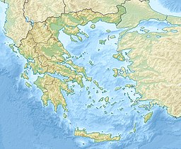
Lake Kerkini (Greek: Λίμνη Κερκίνη – Limni Kerkini) is an artificial reservoir in Central Macedonia, Greece that was created in 1932, and then redeveloped in 1980, on the site of what was previously an extremely extensive marshland.
Lake Kerkini is now one of the premier birdwatching sites in Greece, as it is situated along the migratory flyway for birds en route to the Aegean Sea, the Balkan region, the Black Sea, the Hungarian steppes and beyond.
History
[edit]Before 1932, there were irregular marsh lakes on Strymon, one of them called "Podkova" (in Bulgarian and Slavic Macedonian "Podkova" meaning "Horseshoe", found in Ottoman Turkish records: ݒودقوه كولي Podkova Gölü.[2]).
Kerkini lake was created by making embankments on the eastern and western sides of the river and by a dam constructed near the village of Lithotopos, which started functioning in 1932.
As time went by, the lake's capacity was reduced due to silt deposited by Strymon river. So the raising of the embankments and the construction of a new dam was necessary, which started operating in 1982.
Geography
[edit]The lake's main water source is the Strymon River, although it is also fed by the Kerkinitis river from Krousia.
The lake's surrounding area is flat and semi-mountainous. The lake's size varies from 54 km2 to 72 km2.
The lake is a technical work of great agricultural utility and provides a hydrobiosphere for thousands of water fowls.
Nature
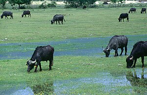
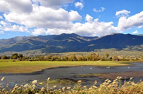
[edit]This biosphere is recouped by the International Convention of Ramsar and presents numerous admirable elements. Thousands of birds, both rare and protected, riverside forests, water-lilies in a large area, fish variety and fantastic panoramic view from the mountains of Belasica and Krousia give it a characteristic tone. Actually the lake hosts 227 kinds of birds, especially non-migrants, of which 76 are recorded in the National Red Catalogue, while at least 31 of them are protected by EEC's Directive concerning wild life. What makes an exceptional presence is the buffalo's herd in the area, plus the one of the jackelo in the area of Lake Kerkini. In the surrounding area of Lake Kerkini there are at least 10 amphibian species (frogs, salamanders, newts, five snail species, 19 reptile species (lizards, snakes, turtles) and a great variety of insects which play an important part in the food chain and contribute towards the biological resources of the lake.
The human intervention usually retracts or takes negative action against the natural processes. Lake Kerkini is a rare example, where the gentle human handling has had the exact opposite result.
Gallery
[edit]-
Krousia mount from the lake
-
Flamingos in the lake
-
White pelicans at the lake
-
Landscape
-
Buffalos at the lake
-
View
-
View
-
The dam of Lake Kerkini
-
Small boat on the lake
References
[edit]- ^ "Artificial Lake Kerkini". Ramsar Sites Information Service. Retrieved 25 April 2018.
- ^ "Harvard Mirador Viewer".


