Braník: Difference between revisions
Appearance
Content deleted Content added
+ref |
Removing from Category:Cadastral territories in the Czech Republic using Cat-a-lot |
||
| (11 intermediate revisions by 10 users not shown) | |||
| Line 1: | Line 1: | ||
{{Short description|Neighborhood of Prague}} |
|||
{{ |
{{About|the district in Prague|the Slovenian city|Branik}} |
||
{{ |
{{more citations needed|date=March 2010}} |
||
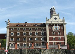
[[File:Branik brewery 1081m.jpg|thumb|260px|The Braník brewery]] |
|||
{{Infobox settlement |
|||
| name = Braník |
|||
| native_name = |
|||
| other_name = |
|||
| settlement_type = Cadastral Area of Prague |
|||
| image_skyline = Branik brewery 1081m.jpg |
|||
| image_caption = The Braník brewery |
|||
| nickname = |
|||
| motto = |
|||
| image_map = Praha KÚ Braník.png |
|||
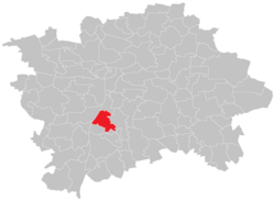
| map_caption = Location of Braník in [[Prague]] |
|||
| pushpin_map = |
|||
| pushpin_map_caption = |
|||
| pushpin_relief = |
|||
| coordinates = {{coord|50|01|59|N|14|25|16|E|display=inline,title}} |
|||
| subdivision_type = Country |
|||
| subdivision_name = [[Czech Republic]] |
|||
| subdivision_type1 = |
|||
| subdivision_name1 = |
|||
| subdivision_type2 = Region |
|||
| subdivision_name2 = [[Prague]] |
|||
| subdivision_type3 = District |
|||
| subdivision_name3 = [[Prague 4]] |
|||
| subdivision_type4 = |
|||
| subdivision_name4 = <!-- maps and coordinates --> |
|||
| established_title = |
|||
| established_date = <!-- area --> |
|||
| area_footnotes = |
|||
| area_total_km2 = 4.40 |
|||
| area_total_sq_mi = |
|||
| area_land_sq_mi = |
|||
| area_water_sq_mi = <!-- elevation --> |
|||
| elevation_m = |
|||
| elevation_ft = <!-- population --> |
|||
| elevation_footnotes = |
|||
| population_total = 17777 |
|||
| population_as_of = 2021 |
|||
| population_footnotes = <ref name=":0">{{cite web |title=Results of the 2021 Census - Open data|language=cs|url=https://csu.gov.cz/produkty/vysledky-scitani-2021-otevrena-data|work=Public Database|publisher=[[Czech Statistical Office]]|date=2021-03-27}}</ref> |
|||
| population_density_km2 = auto |
|||
| population_density_sq_mi = |
|||
| population_demonym = <!-- time zone(s) --> |
|||
| timezone1 = [[Central European Time|CET]] |
|||
| utc_offset1 = +1 |
|||
| timezone1_DST = [[Central European Summer Time|CEST]] |
|||
| utc_offset1_DST = +2 |
|||
<!-- postal codes, area code -->| postal_code_type = Postal code |
|||
| postal_code = 147 00 |
|||
| area_code = |
|||
| area_code_type = |
|||
| geocode = |
|||
| iso_code = <!-- website, footnotes --> |
|||
| website = |
|||
| footnotes = |
|||
| etymology = <!-- location --> |
|||
}} |
|||
| ⚫ | '''Braník''' (sometimes inaccurately called Bráník) is a [[Districts of Prague|district]] and cadastral area in [[Prague]] located in the south of the city, on the east bank of the [[Vltava]]. It used to be known for its [[Braník brewery|brewery]], but the brewery is now out of business as it ceased operations in 2002.<ref>{{Cite web|url=http://ekonomika.idnes.cz/branicky-pivovar-skoncil-branik-se-vari-na-smichove-fhn-/ekonomika.aspx?c=A070207_172601_pivo_ven|title=Branický pivovar skončil, Braník se vaří na Smíchově|date=7 February 2007}}</ref> Braník borders with [[Malá Chuchle]] and [[Hlubočepy]] in the west, [[Podoli (Prague)|Podolí]] in the north, [[Krč]] in the east and [[Lhotka (Prague)|Lhotka]] and [[Hodkovičky]] in the south. |
||
== Demographics == |
|||
| ⚫ | '''Braník''' (sometimes inaccurately called Bráník) is a district in [[Prague]] located in the south of the city, on the east bank of the [[Vltava]]. It |
||
{{historical population|1869|1520|1880|1847|1890|2334|1900|3178|1910|3616|1921|3581|1930|6738|1950|11594|1961|12646|1970|20612|1980|22883|1991|20541|2001|18445|2011|18455|2021|17777|align=none|cols=3|source=Censuses<ref>{{cite web |title=Historický lexikon obcí České republiky 1869–2011 – Praha|url=https://csu.gov.cz/docs/107508/8e8d8a88-22cc-41a3-b523-7b0fbab7c040/130084150100.pdf?version=1.0|publisher=Czech Statistical Office|language=cs|date=2015-12-21}}</ref><ref name=":0" />}} |
|||
== References == |
== References == |
||
{{Reflist}} |
|||
<references /> |
|||
{{Districts and cadastral areas of Prague}} |
{{Districts and cadastral areas of Prague}} |
||
{{Authority control}} |
|||
{{coord|50.0365|14.4112|display=title}} |
|||
{{DEFAULTSORT:Branik}} |
{{DEFAULTSORT:Branik}} |
||
| Line 17: | Line 74: | ||
{{Prague-geo-stub}} |
{{Prague-geo-stub}} |
||
[[Category:Cadastral territories in Prague]] |
|||
[[cs:Braník]] |
|||
[[eo:Braník]] |
|||
[[nl:Braník]] |
|||
[[pl:Braník]] |
|||
[[sk:Braník]] |
|||
Latest revision as of 23:41, 24 October 2024
This article needs additional citations for verification. (March 2010) |
Braník | |
|---|---|
Cadastral Area of Prague | |
 The Braník brewery | |
 Location of Braník in Prague | |
| Coordinates: 50°01′59″N 14°25′16″E / 50.03306°N 14.42111°E | |
| Country | Czech Republic |
| Region | Prague |
| District | Prague 4 |
| Area | |
• Total | 4.40 km2 (1.70 sq mi) |
| Population (2021)[1] | |
• Total | 17,777 |
| • Density | 4,000/km2 (10,000/sq mi) |
| Time zone | UTC+1 (CET) |
| • Summer (DST) | UTC+2 (CEST) |
| Postal code | 147 00 |
Braník (sometimes inaccurately called Bráník) is a district and cadastral area in Prague located in the south of the city, on the east bank of the Vltava. It used to be known for its brewery, but the brewery is now out of business as it ceased operations in 2002.[2] Braník borders with Malá Chuchle and Hlubočepy in the west, Podolí in the north, Krč in the east and Lhotka and Hodkovičky in the south.
Demographics
[edit]
|
|
| ||||||||||||||||||||||||||||||||||||||||||||||||||||||
| Source: Censuses[3][1] | ||||||||||||||||||||||||||||||||||||||||||||||||||||||||
References
[edit]- ^ a b "Results of the 2021 Census - Open data". Public Database (in Czech). Czech Statistical Office. 2021-03-27.
- ^ "Branický pivovar skončil, Braník se vaří na Smíchově". 7 February 2007.
- ^ "Historický lexikon obcí České republiky 1869–2011 – Praha" (PDF) (in Czech). Czech Statistical Office. 2015-12-21.
