Sianky: Difference between revisions
+ info |
|||
| (11 intermediate revisions by 7 users not shown) | |||
| Line 1: | Line 1: | ||
{{Short description|Village in Lviv Oblast, Ukraine}} |
|||
{{Infobox settlement |
{{Infobox settlement |
||
<!-- See Template:Infobox settlement for additional fields and descriptions --> |
<!-- See Template:Infobox settlement for additional fields and descriptions --> |
||
| Line 7: | Line 8: | ||
| total_type = |
| total_type = |
||
| image_skyline = Sianki ukraińska strona.jpg |
| image_skyline = Sianki ukraińska strona.jpg |
||
| image_caption = |
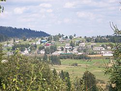
| image_caption = Landscape of Sianky |
||
| image_flag = |
| image_flag = |
||
| image_shield =Syanky gerb.png |
| image_shield =Syanky gerb.png |
||
| Line 24: | Line 25: | ||
| area_total_km2 = 0.7 |
| area_total_km2 = 0.7 |
||
| population_total = 580 |
| population_total = 580 |
||
| population_density_km2 = |
| population_density_km2 = auto |
||
| module = {{Infobox mapframe |wikidata=yes |zoom=11 |height=300 |width= | stroke-width=1 |coord={{WikidataCoord|display=i}}}} |
|||
}} |
}} |
||
| ⚫ | '''Sianky''' ({{ |
||
| ⚫ | '''Sianky''' ({{Langx|uk|Сянки}}; {{Langx|pl|Sianki}}) is a village in [[Sambir Raion]], [[Lviv Oblast]], [[Ukraine]] on the [[San River]]. It is located a few kilometers from the border with [[Poland]], in the south-eastern part of [[Bieszczady Mountains|Bieszczady]]. Sianky belongs to [[Borynia settlement hromada]], one of the [[hromada]]s of Ukraine.<ref name="admreform_2020_borynia">{{cite web |title=Боринская громада |url=https://gromada.info/ru/obschina/borynska/ |publisher=Портал об'єднаних громад України |language=ru}}</ref> |
||
| ⚫ | During |
||
| ⚫ | During 966–1018, 1340–1772 and 1918–1939 Sianky was the part of Poland, while during 1772–1918 it belonged to the [[Austrian Empire|Austrian empire]] (later Austrian-Hungarian empire when double monarchy was introduced in Austria). On September 17, 1939, Sianky was incorporated into the [[Soviet Union]], and since the [[History of the Soviet Union (1985-1991)|collapse of the Soviet Union]] in 1991, it is part of independent [[Ukraine]]. |
||
Until 18 July 2020, Sianky belonged to [[Turka Raion]]. The raion was abolished in July 2020 as part of the administrative reform of Ukraine, which reduced the number of raions of Lviv Oblast to seven. The area of Turka Raion was merged into Sambir Raion.<ref>{{Cite news|title=Про утворення та ліквідацію районів. Постанова Верховної Ради України № 807-ІХ.|url=http://www.golos.com.ua/article/333466|access-date=2020-10-03|date=2020-07-18|website=Голос України|language=uk}}</ref><ref>{{cite web |title=Нові райони: карти + склад |url=https://www.minregion.gov.ua/press/news/novi-rajony-karty-sklad/ |publisher=Міністерство розвитку громад та територій України |language=Ukrainian}}</ref> |
|||
A railway station of [[Lviv]]-[[Uzhhorod]] railroad is located in Sianky. The village's population was about 500 in 2001. |
A railway station of [[Lviv]]-[[Uzhhorod]] railroad is located in Sianky. The village's population was about 500 in 2001. |
||
== References == |
== References == |
||
===Notes=== |
|||
{{reflist}} |
|||
===Sources=== |
|||
*[https://web.archive.org/web/20160304073504/http://w1.c1.rada.gov.ua/pls/z7502/A005?rdat1=01.04.2009&rf7571=21469 rada.gov.ua] |
*[https://web.archive.org/web/20160304073504/http://w1.c1.rada.gov.ua/pls/z7502/A005?rdat1=01.04.2009&rf7571=21469 rada.gov.ua] |
||
| Line 38: | Line 47: | ||
{{Authority control}} |
{{Authority control}} |
||
[[Category:Villages in |
[[Category:Villages in Sambir Raion]] |
||
Latest revision as of 14:20, 25 October 2024
Sianky
Сянки | |
|---|---|
Village | |
 Landscape of Sianky | |
| Coordinates: 49°01′30″N 22°54′00″E / 49.02500°N 22.90000°E | |
| Country | |
| Oblast | |
| Raion | Sambir |
Area | 0.7 km2 (0.3 sq mi) |
| Population | 580 |
| • Density | 830/km2 (2,100/sq mi) |
 | |
Sianky (Ukrainian: Сянки; Polish: Sianki) is a village in Sambir Raion, Lviv Oblast, Ukraine on the San River. It is located a few kilometers from the border with Poland, in the south-eastern part of Bieszczady. Sianky belongs to Borynia settlement hromada, one of the hromadas of Ukraine.[1]
During 966–1018, 1340–1772 and 1918–1939 Sianky was the part of Poland, while during 1772–1918 it belonged to the Austrian empire (later Austrian-Hungarian empire when double monarchy was introduced in Austria). On September 17, 1939, Sianky was incorporated into the Soviet Union, and since the collapse of the Soviet Union in 1991, it is part of independent Ukraine.
Until 18 July 2020, Sianky belonged to Turka Raion. The raion was abolished in July 2020 as part of the administrative reform of Ukraine, which reduced the number of raions of Lviv Oblast to seven. The area of Turka Raion was merged into Sambir Raion.[2][3]
A railway station of Lviv-Uzhhorod railroad is located in Sianky. The village's population was about 500 in 2001.
References
[edit]Notes
[edit]- ^ "Боринская громада" (in Russian). Портал об'єднаних громад України.
- ^ "Про утворення та ліквідацію районів. Постанова Верховної Ради України № 807-ІХ". Голос України (in Ukrainian). 2020-07-18. Retrieved 2020-10-03.
- ^ "Нові райони: карти + склад" (in Ukrainian). Міністерство розвитку громад та територій України.
Sources
[edit]


