Bungo Channel: Difference between revisions
Appearance
Content deleted Content added
No edit summary |
add infobox mapframe for more detail |
||
| (10 intermediate revisions by 7 users not shown) | |||
| Line 4: | Line 4: | ||
| native_name ={{native name|ja|豊後水道}} |
| native_name ={{native name|ja|豊後水道}} |
||
| image = File:Seto-Inland-Sea-Photo.jpg |
| image = File:Seto-Inland-Sea-Photo.jpg |
||
| alt = Bungo Channel Map |
|||
| caption = Bungo Channel Map |
| caption = Bungo Channel Map |
||
| image_bathymetry = |
| image_bathymetry = |
||
| Line 23: | Line 24: | ||
| pushpin_map_alt = |
| pushpin_map_alt = |
||
| pushpin_map_caption = Location of Bungo Channel |
| pushpin_map_caption = Location of Bungo Channel |
||
| mapframe = true |
|||
| mapframe-zoom = 7 |
|||
| coordinates = {{coord|32.909|N|132.25|E|format=dms|region:JP_type:waterbody_dim:600km|display=inline,title}} |
| coordinates = {{coord|32.909|N|132.25|E|format=dms|region:JP_type:waterbody_dim:600km|display=inline,title}} |
||
| coor_pinpoint = |
| coor_pinpoint = |
||
| part_of = |
| part_of = |
||
| alt = |
|||
| type = [[strait]] |
| type = [[strait]] |
||
| cities = [[Ōita (city)|Ōita]], [[Uwajima, Ehime|Uwajima]], [[Seiyo, Ehime|Seiyo]], [[Sukumo, Kōchi|Sukumo]] |
| cities = [[Ōita (city)|Ōita]], [[Uwajima, Ehime|Uwajima]], [[Seiyo, Ehime|Seiyo]], [[Sukumo, Kōchi|Sukumo]] |
||
| Line 35: | Line 37: | ||
}} |
}} |
||
The {{Nihongo|'''Bungo Channel'''|豊後水道|Bungo-suidō<ref>''Teikoku's Complete Atlas of Japan'', Teikoku-Shoin Co.,Ltd., Tokyo, {{ISBN|4-8071-0004-1}}</ref>}} is a [[strait]] separating the [[Japan]]ese islands of [[Kyushu]] and [[Shikoku]]. It connects the [[Philippine Sea]] and the [[Seto Inland Sea]] on the western end of Shikoku.<ref>[[Louis-Frédéric|Nussbaum, Louis-Frédéric]]. (2005). [https://books.google.com/books?id=p2QnPijAEmEC&pg=PA9983 "Bungo Kaikyō"] in ''Japan Encyclopedia'', p. 91.</ref> The narrowest part of this channel is the [[Hōyo Strait]]. |
The {{Nihongo|'''Bungo Channel'''|豊後水道|Bungo-suidō<ref>''Teikoku's Complete Atlas of Japan'', Teikoku-Shoin Co., Ltd., Tokyo, {{ISBN|4-8071-0004-1}}</ref>}} is a [[strait]] separating the [[Japan]]ese islands of [[Kyushu]] and [[Shikoku]]. It connects the [[Philippine Sea]] and the [[Seto Inland Sea]] on the western end of Shikoku.<ref>[[Louis-Frédéric|Nussbaum, Louis-Frédéric]]. (2005). [https://books.google.com/books?id=p2QnPijAEmEC&pg=PA9983 "Bungo Kaikyō"] in ''Japan Encyclopedia'', p. 91.</ref> The narrowest part of this channel is the [[Hōyo Strait]]. |
||
In the [[English-speaking world]], the Bungo Strait is most known as a setting in the 1958 [[World War II]] [[submarine]] film ''[[Run Silent, Run Deep (1958 film)|Run Silent, Run Deep]]'', based upon the best-selling 1955 novel by then-Commander [[Edward L. Beach Jr.]]<ref>Sheffield, Richard. (2009). {{Google books|axdDd82UO3EC|''Subs on the Hunt: 40 of the Greatest WWII Submarine War Patrols''|page=24}}; Leeman, Sergio and Robert Wise. (1995). ''Robert Wise on his Films: from Editing Room to Director's Chair,'' p. 145.</ref> |
In the [[English-speaking world]], the Bungo Strait is most known as a setting in the 1958 [[World War II]] [[submarine]] film ''[[Run Silent, Run Deep (1958 film)|Run Silent, Run Deep]]'', based upon the best-selling 1955 novel by then-Commander [[Edward L. Beach Jr.]]<ref>Sheffield, Richard. (2009). {{Google books|axdDd82UO3EC|''Subs on the Hunt: 40 of the Greatest WWII Submarine War Patrols''|page=24}}; Leeman, Sergio and Robert Wise. (1995). ''Robert Wise on his Films: from Editing Room to Director's Chair,'' p. 145.</ref> |
||
On 9 November |
On 9 November 1944, the [[USS Archerfish (SS-311)|USS ''Archerfish'']] sank the ''[[Japanese aircraft carrier Shinano|Shinano]]'', just nine hours into its maiden voyage in the Bungo strait. Shinano had been built in secret after being converted to a carrier, from a battleship of the Yamato class. |
||
==Notes== |
==Notes== |
||
Latest revision as of 15:50, 26 October 2024
| Bungo Channel | |
|---|---|
| 豊後水道 (Japanese) | |
 Bungo Channel Map | |
| Location | Japan |
| Coordinates | 32°54′32″N 132°15′00″E / 32.909°N 132.25°E |
| Type | strait |
| Basin countries | Japan |
| Settlements | Ōita, Uwajima, Seiyo, Sukumo |
| References | Bungo Strait: Japan National Geospatial-Intelligence Agency, Bethesda, MD, USA |
| Location | |
 | |
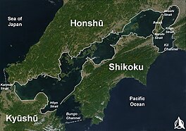
The Bungo Channel (豊後水道, Bungo-suidō[1]) is a strait separating the Japanese islands of Kyushu and Shikoku. It connects the Philippine Sea and the Seto Inland Sea on the western end of Shikoku.[2] The narrowest part of this channel is the Hōyo Strait.
In the English-speaking world, the Bungo Strait is most known as a setting in the 1958 World War II submarine film Run Silent, Run Deep, based upon the best-selling 1955 novel by then-Commander Edward L. Beach Jr.[3] On 9 November 1944, the USS Archerfish sank the Shinano, just nine hours into its maiden voyage in the Bungo strait. Shinano had been built in secret after being converted to a carrier, from a battleship of the Yamato class.
Notes
[edit]- ^ Teikoku's Complete Atlas of Japan, Teikoku-Shoin Co., Ltd., Tokyo, ISBN 4-8071-0004-1
- ^ Nussbaum, Louis-Frédéric. (2005). "Bungo Kaikyō" in Japan Encyclopedia, p. 91.
- ^ Sheffield, Richard. (2009). Subs on the Hunt: 40 of the Greatest WWII Submarine War Patrols, p. 24, at Google Books; Leeman, Sergio and Robert Wise. (1995). Robert Wise on his Films: from Editing Room to Director's Chair, p. 145.
References
[edit]- Leeman, Sergio and Robert Wise. (1995). Robert Wise on his Films: from Editing Room to Director's Chair. Los Angeles: Silman-James. ISBN 9781879505247; OCLC 243829638
- Nussbaum, Louis-Frédéric and Käthe Roth. (2005). Japan encyclopedia. Cambridge: Harvard University Press. ISBN 978-0-674-01753-5; OCLC 58053128
- Sheffield, Richard. (2009). Subs on the Hunt: 40 of the Greatest WWII Submarine War Patrols. Atlanta: Fox Publishing. ISBN 9781442169388; OCLC 652102659

