Salles-Lavalette: Difference between revisions
Appearance
Content deleted Content added
m Remove unused region and department parameters from Template:Infobox French commune to prevent confusion INSEE field is used now. See Wikipedia:Bots/Requests_for_approval/Lonjers_french_region_rename_bot |
|||
| (11 intermediate revisions by 8 users not shown) | |||
| Line 1: | Line 1: | ||
{{Use dmy dates|date=August 2023}} |
|||
{{Infobox French commune |
{{Infobox French commune |
||
|name = Salles-Lavalette |
|name = Salles-Lavalette |
||
|commune status = [[Communes of France|Commune]] |
|||
|image = Salles-Lavalette 16 Mairie 2014.jpg |
|image = Salles-Lavalette 16 Mairie 2014.jpg |
||
|caption = Town hall |
|caption = Town hall |
||
|arrondissement = Angoulême |
|arrondissement = Angoulême |
||
|canton = |
|canton = Tude-et-Lavalette |
||
|INSEE = 16362 |
|INSEE = 16362 |
||
|postal code = 16190 |
|postal code = 16190 |
||
|mayor = Carine Daulon<ref>{{cite web|title=Répertoire national des élus: les maires|url=https://www.data.gouv.fr/fr/datasets/r/2876a346-d50c-4911-934e-19ee07b0e503|publisher=data.gouv.fr, Plateforme ouverte des données publiques françaises|date=13 September 2022|language=fr}}</ref> |
|||
|mayor = Éric Gendron |
|||
|term = |
|term = 2020–2026 |
||
|intercommunality = |
|intercommunality = |
||
| |
|coordinates = {{coord|45.3842|0.2353|format=dms|display=inline,title}} |
||
|latitude = 45.3842 |
|||
|elevation m = 75 |
|elevation m = 75 |
||
|elevation min m = 65 |
|elevation min m = 65 |
||
|elevation max m = 191 |
|elevation max m = 191 |
||
|area km2 = 20.15 |
|area km2 = 20.15 |
||
|population = |
|population = {{France metadata Wikidata|population_total}} |
||
|population date = |
|population date = {{France metadata Wikidata|population_as_of}} |
||
|population footnotes = {{France metadata Wikidata|population_footnotes}} |
|||
}} |
}} |
||
'''Salles-Lavalette''' is a [[Communes of France|commune]] in the [[Charente]] [[Departments of France|department]] in southwestern [[France]]. |
'''Salles-Lavalette''' ({{IPA|fr|sal lavalɛt}}; {{langx|oc|Salas La Valeta}}) is a [[Communes of France|commune]] in the [[Charente]] [[Departments of France|department]] in southwestern [[France]]. |
||
==Geography== |
==Geography== |
||
| Line 27: | Line 29: | ||
==Population== |
==Population== |
||
{{Historical populations |
{{Historical populations |
||
|source = INSEE<ref name=pophist>[https://www.insee.fr/fr/statistiques/7633058?geo=COM-16362#ancre-POP_T1 Population en historique depuis 1968], INSEE</ref> |
|||
| ⚫ | |||
|percentages = pagr |
|||
| 1793|1114 |
|||
| ⚫ | |||
| 1800|1051 |
|||
| ⚫ | |||
| 1806|1223 |
|||
| ⚫ | |||
| 1821|1155 |
|||
| ⚫ | |||
| 1831|1215 |
|||
| ⚫ | |||
| 1841|1175 |
|||
| ⚫ | |||
| 1846|1164 |
|||
|2009 |355 |
|||
| 1851|1151 |
|||
|2014 |360 |
|||
| 1856|1169 |
|||
|2020 |321 |
|||
| 1861|1126 |
|||
| 1866|1116 |
|||
| 1872|1076 |
|||
| 1876|1048 |
|||
| 1881|1007 |
|||
| 1886|973 |
|||
| 1891|895 |
|||
| 1896|863 |
|||
| 1901|836 |
|||
| 1906|879 |
|||
| 1911|900 |
|||
| 1921|714 |
|||
| 1926|765 |
|||
| 1931|780 |
|||
| 1936|761 |
|||
| 1946|678 |
|||
| 1954|591 |
|||
| 1962|539 |
|||
| ⚫ | |||
| ⚫ | |||
| ⚫ | |||
| ⚫ | |||
| ⚫ | |||
| 2008|348 |
|||
}} |
}} |
||
{{clear-left}} |
|||
==See also== |
==See also== |
||
| Line 68: | Line 46: | ||
==References== |
==References== |
||
*[http://www.insee.fr/en/home/home_page.asp INSEE] |
|||
{{reflist}} |
{{reflist}} |
||
{{commons category}} |
|||
{{commonscat}} |
|||
{{Charente communes}} |
{{Charente communes}} |
||
{{authority control}} |
|||
{{DEFAULTSORT:Salleslavalette}} |
{{DEFAULTSORT:Salleslavalette}} |
||
[[Category:Communes of Charente]] |
[[Category:Communes of Charente]] |
||
{{Charente-geo-stub}} |
{{Charente-geo-stub}} |
||
Latest revision as of 08:58, 27 October 2024
Salles-Lavalette | |
|---|---|
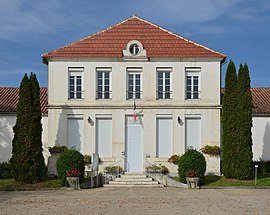
 Town hall | |
| Coordinates: 45°23′03″N 0°14′07″E / 45.3842°N 0.2353°E | |
| Country | France |
| Region | Nouvelle-Aquitaine |
| Department | Charente |
| Arrondissement | Angoulême |
| Canton | Tude-et-Lavalette |
| Government | |
| • Mayor (2020–2026) | Carine Daulon[1] |
Area 1 | 20.15 km2 (7.78 sq mi) |
| Population (2021)[2] | 318 |
| • Density | 16/km2 (41/sq mi) |
| Time zone | UTC+01:00 (CET) |
| • Summer (DST) | UTC+02:00 (CEST) |
| INSEE/Postal code | 16362 /16190 |
| Elevation | 65–191 m (213–627 ft) (avg. 75 m or 246 ft) |
| 1 French Land Register data, which excludes lakes, ponds, glaciers > 1 km2 (0.386 sq mi or 247 acres) and river estuaries. | |
Salles-Lavalette (French pronunciation: [sal lavalɛt]; Occitan: Salas La Valeta) is a commune in the Charente department in southwestern France.
Geography
[edit]The Lizonne forms the commune's eastern border.
Population
[edit]| Year | Pop. | ±% p.a. |
|---|---|---|
| 1968 | 503 | — |
| 1975 | 385 | −3.75% |
| 1982 | 362 | −0.88% |
| 1990 | 365 | +0.10% |
| 1999 | 360 | −0.15% |
| 2009 | 355 | −0.14% |
| 2014 | 360 | +0.28% |
| 2020 | 321 | −1.89% |
| Source: INSEE[3] | ||
See also
[edit]References
[edit]- ^ "Répertoire national des élus: les maires" (in French). data.gouv.fr, Plateforme ouverte des données publiques françaises. 13 September 2022.
- ^ "Populations légales 2021" (in French). The National Institute of Statistics and Economic Studies. 28 December 2023.
- ^ Population en historique depuis 1968, INSEE
Wikimedia Commons has media related to Salles-Lavalette.


