Soulaures: Difference between revisions
Appearance
Content deleted Content added
m (BOT) Rounded off excess precision in coordinate parameters |
|||
| (26 intermediate revisions by 19 users not shown) | |||
| Line 1: | Line 1: | ||
{{Use dmy dates|date=August 2023}} |
|||
{{Infobox French commune |
{{Infobox French commune |
||
|name = Soulaures |
|name = Soulaures |
||
| |
|commune status = [[Communes of France|Commune]] |
||
| |
|image = Soulaures - Mairie.JPG |
||
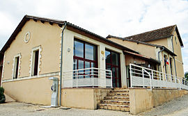
|caption = The town hall in Soulaures |
|||
|arrondissement = Bergerac |
|arrondissement = Bergerac |
||
|canton = |
|canton = Lalinde |
||
|INSEE = 24542 |
|INSEE = 24542 |
||
|postal code = 24540 |
|postal code = 24540 |
||
|mayor = Magalie Pistore<ref>{{cite web|title=Répertoire national des élus: les maires|url=https://www.data.gouv.fr/fr/datasets/r/2876a346-d50c-4911-934e-19ee07b0e503|website=data.gouv.fr, Plateforme ouverte des données publiques françaises|date=2 December 2020|language=fr}}</ref> |
|||
|mayor = Laurence Pistore |
|||
|term = |
|term = 2020–2026 |
||
|intercommunality = |
|intercommunality = |
||
| |
|coordinates = {{coord|44.6511|0.9242|format=dms|display=inline,title}} |
||
|latitude = 44.6511 |
|||
|elevation m = 241 |
|elevation m = 241 |
||
|elevation min m = 168 |
|elevation min m = 168 |
||
|elevation max m = 274 |
|elevation max m = 274 |
||
|area km2 = 10.28 |
|area km2 = 10.28 |
||
|population = |
|population = {{France metadata Wikidata|population_total}} |
||
|population date = |
|population date = {{France metadata Wikidata|population_as_of}} |
||
|population footnotes = {{France metadata Wikidata|population_footnotes}} |
|||
}} |
}} |
||
'''Soulaures''' is a [[Communes of France|commune]] in the [[Dordogne]] [[Departments of France|department]] in [[Aquitaine]] in southwestern [[France]]. |
'''Soulaures''' ({{IPA|fr|suloʁ}}; {{langx|oc|Solaura}}) is a [[Communes of France|commune]] in the [[Dordogne]] [[Departments of France|department]] in [[Nouvelle-Aquitaine]] in southwestern [[France]]. |
||
Church of Saint-Martial built in the twelfth century. The small single nave church has a bell placed at the right wall of the triumphal arch |
Church of Saint-Martial built in the twelfth century. The small single nave church has a bell placed at the right wall of the triumphal arch |
||
==Population== |
==Population== |
||
The inhabitants of Soulaures are called Soulaurais. |
|||
{{Historical populations |
{{Historical populations |
||
|align=left |
|align=left |
||
| Line 35: | Line 39: | ||
|2008|86 |
|2008|86 |
||
}} |
}} |
||
{{clear left}} |
|||
==Economy== |
|||
As of December 31, 2013, the municipality had eleven establishments, eight of them in agriculture, forestry or fishing, one in construction, one in industry, and one in the administrative sector. |
|||
==See also== |
==See also== |
||
| Line 40: | Line 48: | ||
==References== |
==References== |
||
{{commons category}} |
|||
*[http://www.insee.fr/en/home/home_page.asp INSEE] |
|||
{{reflist}} |
{{reflist}} |
||
{{commonscat}} |
|||
{{Dordogne communes}} |
{{Dordogne communes}} |
||
{{authority control}} |
|||
[[Category:Communes of Dordogne]] |
[[Category:Communes of Dordogne]] |
||
| Line 50: | Line 59: | ||
{{Dordogne-geo-stub}} |
{{Dordogne-geo-stub}} |
||
[[ca:Solaura]] |
|||
[[ceb:Soulaures]] |
|||
[[es:Soulaures]] |
|||
[[eu:Soulaures]] |
|||
[[fr:Soulaures]] |
|||
[[it:Soulaures]] |
|||
[[mg:Soulaures]] |
|||
[[ms:Soulaures]] |
|||
[[nl:Soulaures]] |
|||
[[oc:Solaura]] |
|||
[[pms:Soulaures]] |
|||
[[pl:Soulaures]] |
|||
[[pt:Soulaures]] |
|||
[[bug:Soulaures]] |
|||
[[uk:Сулор]] |
|||
[[vi:Soulaures]] |
|||
[[vo:Soulaures]] |
|||
[[war:Soulaures]] |
|||
Latest revision as of 09:22, 27 October 2024
Soulaures | |
|---|---|
 The town hall in Soulaures | |
| Coordinates: 44°39′04″N 0°55′27″E / 44.6511°N 0.9242°E | |
| Country | France |
| Region | Nouvelle-Aquitaine |
| Department | Dordogne |
| Arrondissement | Bergerac |
| Canton | Lalinde |
| Government | |
| • Mayor (2020–2026) | Magalie Pistore[1] |
Area 1 | 10.28 km2 (3.97 sq mi) |
| Population (2021)[2] | 72 |
| • Density | 7.0/km2 (18/sq mi) |
| Time zone | UTC+01:00 (CET) |
| • Summer (DST) | UTC+02:00 (CEST) |
| INSEE/Postal code | 24542 /24540 |
| Elevation | 168–274 m (551–899 ft) (avg. 241 m or 791 ft) |
| 1 French Land Register data, which excludes lakes, ponds, glaciers > 1 km2 (0.386 sq mi or 247 acres) and river estuaries. | |
Soulaures (French pronunciation: [suloʁ]; Occitan: Solaura) is a commune in the Dordogne department in Nouvelle-Aquitaine in southwestern France.
Church of Saint-Martial built in the twelfth century. The small single nave church has a bell placed at the right wall of the triumphal arch
Population
[edit]The inhabitants of Soulaures are called Soulaurais.
| Year | Pop. | ±% |
|---|---|---|
| 1962 | 88 | — |
| 1968 | 85 | −3.4% |
| 1975 | 80 | −5.9% |
| 1982 | 76 | −5.0% |
| 1990 | 72 | −5.3% |
| 1999 | 77 | +6.9% |
| 2008 | 86 | +11.7% |
Economy
[edit]As of December 31, 2013, the municipality had eleven establishments, eight of them in agriculture, forestry or fishing, one in construction, one in industry, and one in the administrative sector.
See also
[edit]References
[edit]Wikimedia Commons has media related to Soulaures.
- ^ "Répertoire national des élus: les maires". data.gouv.fr, Plateforme ouverte des données publiques françaises (in French). 2 December 2020.
- ^ "Populations légales 2021" (in French). The National Institute of Statistics and Economic Studies. 28 December 2023.


