Milíře: Difference between revisions
m Bot: Migrating 7 interwiki links, now provided by Wikidata on d:q1936032 (Report Errors) |
|||
| (19 intermediate revisions by 8 users not shown) | |||
| Line 1: | Line 1: | ||
{{Infobox settlement |
|||
:''See other places named [[Milíře]].'' |
|||
| name = Milíře |
|||
| other_name = |
|||
| settlement_type = [[Obec|Municipality]] |
|||
<!-- images --> |
|||
| image_skyline = MilireCelkovyPohled.jpg |
|||
| image_caption = General view |
|||
| image_flag = Milíře (okres Tachov) vlajka.jpg |
|||
| image_shield = Milíře (okres Tachov) znak.jpg |
|||
<!-- location --> |
|||
| subdivision_type = Country |
|||
| subdivision_name = {{CZE}} |
|||
| subdivision_type1 = [[Regions of the Czech Republic|Region]] |
|||
| subdivision_name1 = [[Plzeň Region|Plzeň]] |
|||
| subdivision_type2 = [[Districts of the Czech Republic|District]] |
|||
| subdivision_name2 = [[Tachov District|Tachov]] |
|||
<!-- maps and coordinates --> |
|||
| image_map = |
|||
| map_caption = |
|||
| pushpin_map = Czech Republic |
|||
| pushpin_relief = 1 |
|||
| pushpin_map_caption = Location in the Czech Republic |
|||
| coordinates = {{coord|49|47|47|N|12|33|2|E|display=inline,title}} |
|||
| coordinates_footnotes = |
|||
<!-- government type, leaders --> |
|||
| leader_title = |
|||
| leader_name = |
|||
<!-- established --> |
|||
| established_title = First mentioned |
|||
| established_date = 1669 |
|||
<!-- area --> |
|||
| area_footnotes = |
|||
| area_total_km2 = 14.89 |
|||
<!-- elevation --> |
|||
| elevation_footnotes = |
|||
| elevation_m = 635 |
|||
<!-- population --> |
|||
| population_as_of = 2024-01-01 |
|||
| population_footnotes = <ref>{{cite web |title=Population of Municipalities – 1 January 2024|url=https://csu.gov.cz/produkty/population-of-municipalities-qexb0dqr2d|publisher=[[Czech Statistical Office]]|date=2024-05-17}}</ref> |
|||
| population_total = 235 |
|||
| population_density_km2 = auto |
|||
<!-- time zone(s) --> |
|||
| timezone1 = [[Central European Time|CET]] |
|||
| utc_offset1 = +1 |
|||
| timezone1_DST = [[Central European Summer Time|CEST]] |
|||
| utc_offset1_DST = +2 |
|||
<!-- postal codes, area code --> |
|||
| postal_code_type = Postal code |
|||
| postal_code = 347 01 |
|||
| area_code_type = |
|||
| area_code = |
|||
<!-- website, footnotes --> |
|||
| website = {{URL|https://www.obec-milire.cz/}} |
|||
| footnotes = |
|||
}} |
|||
'''Milíře''' ({{langx|de|Brand}}, ''Tachauer Brand'') is a municipality and village in [[Tachov District]] in the [[Plzeň Region]] of the [[Czech Republic]]. It has about 200 inhabitants. |
|||
==Administrative parts== |
|||
{| border="1" cellpadding="2" cellspacing="0" align="right" |
|||
The village of Zadní Milíře is an administrative part of Milíře. |
|||
|- |
|||
! colspan="2" align="center" bgcolor="#E0922E" | '''Map''' |
|||
|- |
|||
| colspan="2" align="center" | [[Image:Location of Czech city Tachov.png|Map of the Czech Republic highlighting Milíře]] |
|||
|} |
|||
==Etymology== |
|||
'''Milíře''' ([[German language|German]]: ''(Tachauer) Brand'') is a village in the Czech Republik, in the region of [[Plzeň]], near the town of [[Tachov]] ([[German language|German]]: ''Tachau''). |
|||
The name literally means '[[charcoal pile]]s'. |
|||
==Geography== |
|||
The first written document mentioning Milíře comes from 1669. The church of Miliře was built in 1814. |
|||
Milíře is located about {{convert|6|km|0}} west of [[Tachov]] and {{convert|58|km|abbr=on}} west of [[Plzeň]]. It lies in the [[Upper Palatinate Forest]]. The highest point is at {{convert|750|m|ft|abbr=on}} above sea level. |
|||
==History== |
|||
In 1946 most German-speaking inhabitants, the majority in the village and the Tachov area, were [[Expulsion of Germans after World War II|expelled]]. After the war, the area was only partly repopulated. |
|||
The first written mention of Milíře is from 1669. Zadní Milíře was first mentioned in 1778.<ref name=history>{{cite web |title=Historie|url=https://www.obec-milire.cz/obec/historie/|publisher=Obec Milíře|language=cs|access-date=2022-09-21}}</ref> |
|||
In 1946, most German-speaking inhabitants were [[Expulsion of Germans after World War II|expelled]]. After the war, the area was only partly repopulated. |
|||
After the "velvet revolution" (1989), German companies started to operate factories to make use of the cheap labour in the Tachov area. However, the area is still among the economically least developed Czech regions. |
|||
==Demographics== |
|||
In 1999 the future king of the Netherlands, Prince Willem Alexander, came to shoot pheasants in Miliře. See: "Social dynamics in a Bohemian village" (external link below). |
|||
{{historical populations |
|||
|align=none|cols=3 |
|||
|1869|1859 |
|||
|1880|1814 |
|||
|1890|1843 |
|||
|1900|1852 |
|||
|1910|1910 |
|||
|1921|1825 |
|||
|1930|1720 |
|||
|1950|328 |
|||
|1961|448 |
|||
|1970|359 |
|||
|1980|93 |
|||
|1991|81 |
|||
|2001|198 |
|||
|2011|235 |
|||
|2021|250 |
|||
|source=Censuses<ref>{{cite web |title=Historický lexikon obcí České republiky 1869–2011|url=https://csu.gov.cz/produkty/historicky-lexikon-obci-1869-az-2015|publisher=[[Czech Statistical Office]]|language=cs|date=2015-12-21}}</ref><ref>{{cite web |title=Population Census 2021: Population by sex|url=https://vdb.czso.cz/vdbvo2/faces/en/index.jsf?page=vystup-objekt-parametry&z=T&f=TABULKA&sp=A&skupId=4429&katalog=33515&pvo=SLD21001-OB-OK|work=Public Database|publisher=[[Czech Statistical Office]]|date=2021-03-27}}</ref>}} |
|||
==Transport== |
|||
==Other towns in Tachov miniregion== |
|||
[[File:MilireKostel.jpg|thumb|160px|Church of Saints Peter and Paul]] |
|||
[[Konstantinovy Lázně]], [[Rozvadov]], [[Stříbro]], [[Kladruby (Tachov District)|Kladruby]], chateau [[Trpisty]], [[Halže]], [[Tachov]]. |
|||
There are no railways or major roads passing through the municipality. |
|||
== |
==Sights== |
||
The main landmark of Milíře is the Church of Saints Peter and Paul. It was built in the Neoclassical style in 1814–1816. Together with the rectory, school, memorial cross and World War I memorial, it forms a valuable set of historical buildings.<ref>{{cite web |title=Kostel sv. Petra a Pavla|url=https://pamatkovykatalog.cz/kostel-sv-petra-a-pavla-18809128|publisher=National Heritage Institute|language=cs|access-date=2022-09-21}}</ref> |
|||
* [http://www.volny.cz/ou.milire/ Website Obec Miliře (in Czech)] |
|||
* [http://www.jz.cz/lucina/obce/milire/ Website Miliře (in Czech)] |
|||
* [http://www.foruminst.sk/publ/nostratempora/8/nostratempora8_svasek.pdf Social dynamics in a Bohemian village (a scientific article about Miliře)] |
|||
==References== |
|||
{{coord|49|47|40|N|12|33|12|E|region:CZ|display=title}} |
|||
{{reflist}} |
|||
==External links== |
|||
{{commons category|Milíře (Tachov District)}} |
|||
*{{official|https://www.obec-milire.cz/}} |
|||
{{ |
{{Tachov District}} |
||
[[Category:Villages in the Czech Republic]] |
|||
[[Category:Tachov District]] |
|||
{{authority control}} |
|||
{{Plzeň-geo-stub}} |
|||
{{DEFAULTSORT:Milire}} |
|||
[[ms:Milíře (Daerah Tachov)]] |
|||
[[Category:Villages in Tachov District]] |
|||
Latest revision as of 07:20, 28 October 2024
Milíře | |
|---|---|
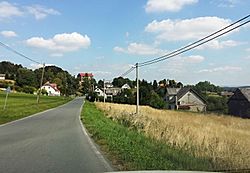
 General view | |
| Coordinates: 49°47′47″N 12°33′2″E / 49.79639°N 12.55056°E | |
| Country | |
| Region | Plzeň |
| District | Tachov |
| First mentioned | 1669 |
| Area | |
• Total | 14.89 km2 (5.75 sq mi) |
| Elevation | 635 m (2,083 ft) |
| Population (2024-01-01)[1] | |
• Total | 235 |
| • Density | 16/km2 (41/sq mi) |
| Time zone | UTC+1 (CET) |
| • Summer (DST) | UTC+2 (CEST) |
| Postal code | 347 01 |
| Website | www |
Milíře (German: Brand, Tachauer Brand) is a municipality and village in Tachov District in the Plzeň Region of the Czech Republic. It has about 200 inhabitants.
Administrative parts
[edit]The village of Zadní Milíře is an administrative part of Milíře.
Etymology
[edit]The name literally means 'charcoal piles'.
Geography
[edit]Milíře is located about 6 kilometres (4 mi) west of Tachov and 58 km (36 mi) west of Plzeň. It lies in the Upper Palatinate Forest. The highest point is at 750 m (2,460 ft) above sea level.
History
[edit]The first written mention of Milíře is from 1669. Zadní Milíře was first mentioned in 1778.[2]
In 1946, most German-speaking inhabitants were expelled. After the war, the area was only partly repopulated.
Demographics
[edit]
|
|
| ||||||||||||||||||||||||||||||||||||||||||||||||||||||
| Source: Censuses[3][4] | ||||||||||||||||||||||||||||||||||||||||||||||||||||||||
Transport
[edit]
There are no railways or major roads passing through the municipality.
Sights
[edit]The main landmark of Milíře is the Church of Saints Peter and Paul. It was built in the Neoclassical style in 1814–1816. Together with the rectory, school, memorial cross and World War I memorial, it forms a valuable set of historical buildings.[5]
References
[edit]- ^ "Population of Municipalities – 1 January 2024". Czech Statistical Office. 2024-05-17.
- ^ "Historie" (in Czech). Obec Milíře. Retrieved 2022-09-21.
- ^ "Historický lexikon obcí České republiky 1869–2011" (in Czech). Czech Statistical Office. 2015-12-21.
- ^ "Population Census 2021: Population by sex". Public Database. Czech Statistical Office. 2021-03-27.
- ^ "Kostel sv. Petra a Pavla" (in Czech). National Heritage Institute. Retrieved 2022-09-21.


