Blejska Dobrava: Difference between revisions
Rescuing 1 sources and tagging 0 as dead.) #IABot (v2.0 |
|||
| (10 intermediate revisions by 5 users not shown) | |||
| Line 109: | Line 109: | ||
}} |
}} |
||
'''Blejska Dobrava''' ({{IPA|sl|ˈbleːi̯ska dɔˈbɾaːʋa|pron}}, {{langx|de|Dobrawa bei Asp}}<ref name="Leksikon">{{cite book |title=Leksikon občin kraljestev in dežel zastopanih v državnem zboru, vol. 6: Kranjsko |date=1906 |publisher=C. Kr. Dvorna in Državna Tiskarna |location=Vienna |page=146}}</ref>) is a settlement in the [[Municipality of Jesenice]], in the [[Upper Carniola]] region of [[Slovenia]]. |
|||
| ⚫ | |||
==Geography== |
|||
Once predominantly agricultural, it has partially urbanized under the influence of industry from the nearby municipal seat of [[Jesenice, Jesenice|Jesenice]]. There is a manufacturing plant, tracing its roots back to a prewar electrode factory, as well as two smaller industrial facilities. The Vintgar [[hydroelectric plant]] on the Radovna stands nearby, as does the scenic [[Vintgar|Vintgar Gorge]], a popular tourist attraction. |
|||
Blejska Dobrava is located at the base of the [[Mežakla]] Plateau, on a series of river terraces between the right bank of the [[Sava Dolinka]] and the [[Radovna (river)|Radovna River]] as it exits the [[Vintgar Gorge]]. The Vintgar [[hydroelectric plant]] on the Radovna stands nearby, as does the scenic [[Vintgar|Vintgar Gorge]], a popular tourist attraction. The settlement is located on the road connecting the [[Upper Sava Valley]] to Bled (through the hamlet of Poljane in [[Spodnje Gorje]]). The [[Bohinj Railway|Jesenice–Bohinj railroad]] also passes through, stopping at a small station. The Jesenice municipal cemetery is located nearby. The Koroška Bela Primary School, in the village of [[Koroška Bela]] across the Sava Valley, operates a branch location in Blejska Dobrava. |
|||
==Name== |
|||
The Koroška Bela Primary School, in the village of [[Koroška Bela]] across the Sava Valley, operates a branch location in Blejska Dobrava. |
|||
Blejska Dobrava was attested in written sources as ''Harde'' in 1253, ''Hard'' in 1368, and ''Oberhardt'' in 1498.<ref>{{cite web |title=Blejska Dobrava |url=https://topografija.zrc-sazu.si/ |website=Slovenska historična topografija |publisher=ZRC SAZU Zgodovinski inštitut Milka Kosa |access-date=February 15, 2021}}</ref> The modern Slovene name ''Blejska Dobrava'' (literally, 'Bled Dobrava') reflects its original connection to the nearby town of [[Bled]]. The place name ''Dobrava'' is relatively frequent in Slovenia. It is derived from the Slovene common noun ''dobrava'' 'gently rolling partially wooded land' (and archaically 'woods, grove'). The name therefore refers to the local geography.<ref>{{cite book |last1=Snoj |first1=Marko |title=Etimološki slovar slovenskih zemljepisnih imen |date=2009 |publisher=Modrijan |location=Ljubljana |page=111}}</ref> |
|||
==History== |
|||
The settlement is located on the road connecting the [[Upper Sava Valley]] to Bled (through the hamlet of Poljane in [[Spodnje Gorje]]). The [[Bohinj Railway|Jesenice–Bohinj railroad]] also passes through, stopping at a small station. The Jesenice municipal cemetery is located nearby. |
|||
| ⚫ | Blejska Dobrava is one of the oldest villages in the area, attested from the 12th century,<ref>{{Cite web |url=http://zupnija-koroska-bela.si/index.php?id=10 |title=Koroška Bela Parish web site |access-date=2008-10-12 |archive-url=https://web.archive.org/web/20080409175333/http://www.zupnija-koroska-bela.si/index.php?id=10 |archive-date=2008-04-09 |url-status=dead }}</ref> Once predominantly agricultural, Blejska Dobrava has partially urbanized under the influence of industry from the nearby municipal seat of [[Jesenice, Jesenice|Jesenice]]. There is a manufacturing plant, tracing its roots back to a prewar electrode factory, as well as two smaller industrial facilities. |
||
==St. Stephen's Church== |
==St. Stephen's Church== |
||
St. Stephen's Church ({{ |
St. Stephen's Church ({{langx|sl|Cerkev svetega Štefana}}), dedicated to [[Saint Stephen]], was originally [[Gothic architecture|Gothic]], with a rectangular nave and pentagonal presbytery, but was rebuilt in 1743 in the [[Baroque]] style. A wall around the church encloses the old, abandoned graveyard, with some of the older graves still marked, including the grave of two sisters (Katra and Jera) of the poet [[France Prešeren]], built into the church's outside wall. |
||
==See also== |
==See also== |
||
[[Dobrava (toponym)]] |
* [[Dobrava (toponym)]] |
||
==References== |
==References== |
||
| Line 127: | Line 130: | ||
==External links== |
==External links== |
||
* {{ |
* {{commons category-inline|Blejska Dobrava}} |
||
* [ |
* [https://www.geopedia.world/#T12_L362_F2473:589_x1570218.838117174_y5845917.735377029_s15_b2345 Blejska Dobrava on Geopedia] |
||
{{Jesenice}} |
{{Jesenice}} |
||
{{Authority control}} |
|||
[[Category:Populated places in the Municipality of Jesenice]] |
[[Category:Populated places in the Municipality of Jesenice]] |
||
Latest revision as of 12:28, 28 October 2024
Blejska Dobrava | |
|---|---|
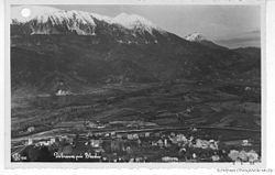
 Postcard of Blejska Dobrava | |
| Coordinates: 46°24′45″N 14°5′41″E / 46.41250°N 14.09472°E | |
| Country | |
| Traditional region | Upper Carniola |
| Statistical region | Upper Carniola |
| Municipality | Jesenice |
| Elevation | 582 m (1,909 ft) |
| Population (2002) | |
• Total | 977 |
| [1] | |
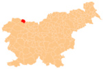
Blejska Dobrava (pronounced [ˈbleːi̯ska dɔˈbɾaːʋa], German: Dobrawa bei Asp[2]) is a settlement in the Municipality of Jesenice, in the Upper Carniola region of Slovenia.
Geography
[edit]Blejska Dobrava is located at the base of the Mežakla Plateau, on a series of river terraces between the right bank of the Sava Dolinka and the Radovna River as it exits the Vintgar Gorge. The Vintgar hydroelectric plant on the Radovna stands nearby, as does the scenic Vintgar Gorge, a popular tourist attraction. The settlement is located on the road connecting the Upper Sava Valley to Bled (through the hamlet of Poljane in Spodnje Gorje). The Jesenice–Bohinj railroad also passes through, stopping at a small station. The Jesenice municipal cemetery is located nearby. The Koroška Bela Primary School, in the village of Koroška Bela across the Sava Valley, operates a branch location in Blejska Dobrava.
Name
[edit]Blejska Dobrava was attested in written sources as Harde in 1253, Hard in 1368, and Oberhardt in 1498.[3] The modern Slovene name Blejska Dobrava (literally, 'Bled Dobrava') reflects its original connection to the nearby town of Bled. The place name Dobrava is relatively frequent in Slovenia. It is derived from the Slovene common noun dobrava 'gently rolling partially wooded land' (and archaically 'woods, grove'). The name therefore refers to the local geography.[4]
History
[edit]Blejska Dobrava is one of the oldest villages in the area, attested from the 12th century,[5] Once predominantly agricultural, Blejska Dobrava has partially urbanized under the influence of industry from the nearby municipal seat of Jesenice. There is a manufacturing plant, tracing its roots back to a prewar electrode factory, as well as two smaller industrial facilities.
St. Stephen's Church
[edit]St. Stephen's Church (Slovene: Cerkev svetega Štefana), dedicated to Saint Stephen, was originally Gothic, with a rectangular nave and pentagonal presbytery, but was rebuilt in 1743 in the Baroque style. A wall around the church encloses the old, abandoned graveyard, with some of the older graves still marked, including the grave of two sisters (Katra and Jera) of the poet France Prešeren, built into the church's outside wall.
See also
[edit]References
[edit]- ^ Statistical Office of the Republic of Slovenia
- ^ Leksikon občin kraljestev in dežel zastopanih v državnem zboru, vol. 6: Kranjsko. Vienna: C. Kr. Dvorna in Državna Tiskarna. 1906. p. 146.
- ^ "Blejska Dobrava". Slovenska historična topografija. ZRC SAZU Zgodovinski inštitut Milka Kosa. Retrieved February 15, 2021.
- ^ Snoj, Marko (2009). Etimološki slovar slovenskih zemljepisnih imen. Ljubljana: Modrijan. p. 111.
- ^ "Koroška Bela Parish web site". Archived from the original on 2008-04-09. Retrieved 2008-10-12.
External links
[edit] Media related to Blejska Dobrava at Wikimedia Commons
- Blejska Dobrava on Geopedia


