Rače: Difference between revisions
m m |
|||
| (13 intermediate revisions by 8 users not shown) | |||
| Line 13: | Line 13: | ||
|image_seal = |
|image_seal = |
||
|seal_size = |
|seal_size = |
||
|image_shield = |
|image_shield = Coat of arms of Rače-Fram.png |
||
|shield_size = |
|shield_size = |
||
|image_blank_emblem = |
|image_blank_emblem = |
||
| Line 31: | Line 31: | ||
|pushpin_label_position = left |
|pushpin_label_position = left |
||
|pushpin_map_caption = Location in Slovenia |
|pushpin_map_caption = Location in Slovenia |
||
|coordinates_display = inline,title |
|||
|coordinates_region = SI |
|||
|subdivision_type = Country |
|subdivision_type = Country |
||
|subdivision_name = [[Image:Flag of Slovenia.svg|25px]] [[Slovenia]] |
|subdivision_name = [[Image:Flag of Slovenia.svg|25px]] [[Slovenia]] |
||
|subdivision_type1 = Traditional region |
|subdivision_type1 = Traditional region |
||
|subdivision_name1 = [[Lower Styria]] |
|subdivision_name1 = [[Lower Styria|Styria]] |
||
|subdivision_type2 = [[Statistical regions of Slovenia|Statistical region]] |
|subdivision_type2 = [[Statistical regions of Slovenia|Statistical region]] |
||
|subdivision_name2 = [[ |
|subdivision_name2 = [[Drava Statistical Region|Drava]] |
||
|subdivision_type3 = [[Municipalities of Slovenia|Municipality]] |
|subdivision_type3 = [[Municipalities of Slovenia|Municipality]] |
||
|subdivision_name3 = [[Rače-Fram]] |
|subdivision_name3 = [[Municipality of Rače–Fram|Rače-Fram]] |
||
|subdivision_type4 = |
|subdivision_type4 = |
||
|subdivision_name4 = |
|subdivision_name4 = |
||
| Line 75: | Line 73: | ||
|area_blank1_km2 = |
|area_blank1_km2 = |
||
|area_blank1_sq_mi = |
|area_blank1_sq_mi = |
||
|population_as_of = |
|population_as_of = 2017 |
||
|population_footnotes = |
|population_footnotes = |
||
|population_note = |
|population_note = |
||
|population_total = |
|population_total = 2693 |
||
|population_density_km2 = |
|population_density_km2 = |
||
|population_density_sq_mi = |
|population_density_sq_mi = |
||
| Line 97: | Line 95: | ||
|timezone_DST = |
|timezone_DST = |
||
|utc_offset_DST = |
|utc_offset_DST = |
||
|coordinates = {{coord|46|27|10.31|N|15|40|52.35|E|region:SI|display=inline,title}} |
|||
|latd= 46|latm=27|lats=10.31 |latNS=N |
|||
|longd=15|longm= 40|longs=52.35 |longEW=E |
|||
|elevation_footnotes = |
|elevation_footnotes = |
||
|elevation_m = 260.4 |
|elevation_m = 260.4 |
||
| Line 112: | Line 109: | ||
|footnotes = <ref>[http://www.stat.si/eng/index.asp Statistical Office of the Republic of Slovenia]</ref> |
|footnotes = <ref>[http://www.stat.si/eng/index.asp Statistical Office of the Republic of Slovenia]</ref> |
||
}} |
}} |
||
'''Rače''' is a settlement in and the administrative centre of the [[ |
'''Rače''' ({{IPA|sl|ˈɾaːtʃɛ|pron}}, in older sources also ''Račje'',<ref name="Leksikon">{{cite book |title=Leksikon občin kraljestev in dežel zastopanih v državnem zboru, vol. 4: Štajersko |year=1904 |publisher=C. Kr. Dvorna in Državna Tiskarna |location=Vienna |page=204}}</ref> {{langx|de|Kranichsfeld}}<ref name="Leksikon"/>) is a settlement in and the administrative centre of the [[Municipality of Rače–Fram]] in northeastern [[Slovenia]]. It lies under the eastern [[Pohorje]] Hills on the edge of the plain on the right bank of the [[Drava]] River south of [[Maribor]]. The area is part of the traditional region of [[Lower Styria|Styria]]. The municipality is now included in the [[Drava Statistical Region]].<ref>[http://www.race-fram.si/ Rače-Fram municipal site]</ref> |
||
Rače Castle is a 16th |
Rače Castle is a 16th-century [[castle]] west of the settlement. It was built between 1528 and 1533 and was originally surrounded by a [[moat]]. In the 17th century two round towers and a [[chapel]] dedicated to [[John of Nepomuk|Saint John of Nepomuk]] were added to the building. A square tower on the opposite side of the building dates to 1915.<ref>[http://rkd.situla.org/ Slovenian Ministry of Culture register of national heritage] reference number ešd 8945</ref> |
||
==References== |
==References== |
||
| Line 120: | Line 117: | ||
==External links== |
==External links== |
||
*[ |
*[https://www.geopedia.world/#T12_L362_F2473:3178_x1746394.3841957357_y5853065.200627105_s15_b2345 Rače on Geopedia] |
||
{{Rače-Fram}} |
{{Rače-Fram}} |
||
{{Authority control}} |
|||
{{DEFAULTSORT:Race}} |
{{DEFAULTSORT:Race}} |
||
[[Category:Populated places in the Municipality of Rače-Fram]] |
[[Category:Populated places in the Municipality of Rače-Fram]] |
||
| ⚫ | |||
| ⚫ | |||
[[nl:Rače]] |
|||
[[sl:Rače]] |
|||
[[sr:Раче]] |
|||
Latest revision as of 17:33, 30 October 2024
Rače | |
|---|---|
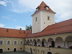
 Rače Castle | |
| Coordinates: 46°27′10.31″N 15°40′52.35″E / 46.4528639°N 15.6812083°E | |
| Country | |
| Traditional region | Styria |
| Statistical region | Drava |
| Municipality | Rače-Fram |
| Area | |
• Total | 8.48 km2 (3.27 sq mi) |
| Elevation | 260.4 m (854.3 ft) |
| Population (2017) | |
• Total | 2,693 |
| [1] | |
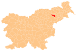
Rače (pronounced [ˈɾaːtʃɛ], in older sources also Račje,[2] German: Kranichsfeld[2]) is a settlement in and the administrative centre of the Municipality of Rače–Fram in northeastern Slovenia. It lies under the eastern Pohorje Hills on the edge of the plain on the right bank of the Drava River south of Maribor. The area is part of the traditional region of Styria. The municipality is now included in the Drava Statistical Region.[3]
Rače Castle is a 16th-century castle west of the settlement. It was built between 1528 and 1533 and was originally surrounded by a moat. In the 17th century two round towers and a chapel dedicated to Saint John of Nepomuk were added to the building. A square tower on the opposite side of the building dates to 1915.[4]
References
[edit]- ^ Statistical Office of the Republic of Slovenia
- ^ a b Leksikon občin kraljestev in dežel zastopanih v državnem zboru, vol. 4: Štajersko. Vienna: C. Kr. Dvorna in Državna Tiskarna. 1904. p. 204.
- ^ Rače-Fram municipal site
- ^ Slovenian Ministry of Culture register of national heritage reference number ešd 8945
External links
[edit]


