Van Fortress: Difference between revisions
LouisAragon (talk | contribs) We now have a separate/proper article for the inscription. |
|||
| (43 intermediate revisions by 32 users not shown) | |||
| Line 1: | Line 1: | ||
{{Short description|Massive stone fortification in Turkey}} |
|||
{{Infobox Military Structure |
|||
{{Infobox military installation |
|||
|name = Van Fortress/ <br/> Van Citadel |
|||
| |
| name = Van Fortress |
||
| |
| partof = |
||
| |
| location = [[Van Province|Van]], [[Turkey]] |
||
| |
| image = [[File:Van Fortress From Northwest.JPG|275px]] |
||
| caption = Van Fortress as seen from the northwest |
|||
|map_type |
| map_type = Turkey#Near East |
||
|coordinates |
| coordinates = {{Coord|38|30|09|N|43|20|24|E|type:landmark|display=inline,title}} |
||
| ⚫ | |||
| |
| map_size = 275 |
||
| map_caption = Shown within Turkey |
|||
|type = Fortress |
|||
| |
| map_relief = yes |
||
| |
| type = Fortress |
||
| |
| code = |
||
| |
| built = 8th and 7th centuries BC |
||
| |
| builder = |
||
| materials = Unmortared basalt (lower walls) and mud-bricks |
|||
| ⚫ | |||
| |
| height = |
||
| ⚫ | |||
| ⚫ | |||
| demolished = Partially |
|||
|ownership = |
|||
| ⚫ | |||
| ⚫ | |||
| |
| ownership = |
||
| ⚫ | |||
|garrison = |
|||
| controlledby = |
|||
| ⚫ | |||
| |
| garrison = |
||
| ⚫ | |||
|occupants = |
|||
| |
| commanders = |
||
| |
| occupants = |
||
| battles = |
|||
| ⚫ | |||
}} |
}} |
||
The '''Fortress of Van''' ([[Armenian language|Armenian]]: Վանի Բերդ, also known as '''Van Citadel''' |
The '''Fortress of Van''' ([[Armenian language|Armenian]]: Վանի Բերդ, also known as '''Van Citadel'''; {{langx|ku|'''Kela Wanê'''}}; {{langx|tr|'''Van Kalesi'''}}) is a massive stone fortification built by the ancient kingdom of [[Urartu]] during the 9th to 7th centuries BC, and is the largest example of its kind. It overlooks the ruins of [[Tushpa]], the ancient Urartian capital during the 9th century, which was centered upon the steep-sided bluff where the fortress now sits. A number of similar fortifications were built throughout the Urartian kingdom, usually cut into hillsides and outcrops in places where modern-day [[Armenia]], [[Turkey]] and [[Iran]] meet. Successive groups such as the Medes, Achaemenids, Armenians, Parthians, Romans, Sassanid Persians, Byzantines, Arabs, Seljuks, Safavids, Afsharids, Ottomans and Russians each controlled the fortress at one time or another. The ancient fortress is located just west of [[Van, Turkey|Van]] and east of [[Lake Van]] in the [[Van Province]] of [[Turkey]]. |
||
[[Silva Tipple New Lake]] led an American expedition to the ruins in 1938-40.<ref>{{Cite book |url=https://books.google.com/books?id=jHXhAAAAMAAJ&q=tipple |title=Who was who in America |date=1943 |publisher=Marquis-Who's Who |isbn=978-0-8379-0205-0 |language=en}}</ref> Most of the finds and field records from this were lost in the sinking of the [[SS Athenia (1922)|S.S. Athenia]] in 1940. |
|||
| ⚫ | |||
| ⚫ | |||
| ⚫ | |||
| ⚫ | A stereotyped trilingual inscription of [[Xerxes the Great]] from the 5th century BC is inscribed upon a smoothed section of the rock face, some 20 meters (60 feet) above the ground near the fortress. The niche was originally carved out by Xerxes' father [[Darius I of Persia|King Darius]], but left the surface blank. The inscription survives in near perfect condition and is divided into three columns of 27 lines written in (from left to right) [[Old Persian]], [[ |
||
| ⚫ | Such fortresses were used for regional control, rather than as a defense against foreign armies. The ruins of this fortress sit outside the modern city of [[Van, Turkey|Van]], where they support walls built in the [[medieval]] era.<ref>The Seventy Wonders of the Ancient World</ref>{{full citation needed|date=October 2019}} |
||
<small>{{quotation|"A great god is [[Ahuramazda]], the greatest of gods, who created this earth, who created that sky, who created man, who created happiness for man, who made Xerxes king, one king for all, one ruler for all. |
|||
<br> |
|||
I am Xerxes, the great king, the king of kings, king of all kinds of peoples with all kinds of origins, king of this earth great and wide, the son of king Darius, the Achaemenid. |
|||
<br> |
|||
King Xerxes says: [[Darius I of Persia|King Darius]], my father, by the grace of Ahuramazda built much that was good, and he gave orders to dig this niche out, but because he did not make an inscription, I ordered this inscription to be made. |
|||
<br> |
|||
May Ahuramazda and the other gods protect me, my kingdom, and what I have made."}}</small> |
|||
== The "Royal Stable" == |
|||
When it was published by [[Eugène Burnouf]] in 1836,<ref>Burnouf, ''Mémoire sur deux inscriptions cunéiformes trouvées près d'Hamadan et qui font partie des papiers du Dr Schulz'', Paris, 1836; Schulz, an orientalist from Hesse, had been sent out by the French foreign ministry to copy inscriptions but had been murdered in 1829; see Arthur John Booth, ''The Discovery and Decipherment of the Trilingual Cuneiform Inscriptions'' 1902, esp. pp 95ff, 206.</ref> through his realization that it included a list of the [[satrap]]ies of [[Darius I of Persia|Darius]] (repeated by Xerxes in nearly identical language), he was able to identify and publish an alphabet of thirty letters, most of which he had correctly deciphered. Burnouf's reading of the Van trilingual inscription had made a significant contribution to the deciphering of [[Old Persian]] cuneiform.<ref>[[:File:Trilingual inscription of Xerxes, Inscription on Van castle, Van Kalesi 2009.jpg|Another photograph of the inscription]].</ref> |
|||
At the Van Citadel, there is a "royal stable" (''Siršini'') of the dimensions of 20 m length, 9 m width and 2,5 m height, carved in rock. Oxen and sheep were held here to be sacrificed for the Urartian gods, according to the inscriptions discovered at the location.<ref>{{Cite book|title=The Socio-Economic Organisation of the Urartian Kingdom|last=Çiftçi|first=Ali|publisher=Brill|year=2017|isbn=9789004347588|pages=113–114}}</ref> |
|||
==Achaemenid inscription== |
|||
[[Silva Tipple New Lake]] led an American expedition to the ruins in 1938-40.<ref>''Who Was Who in America'', v. 5, 1969-1973 https://books.google.com/books?ei=KItvTuLtHcjh0QGj8uWCCg&ct=result&id=jHXhAAAAMAAJ&q=tipple</ref> |
|||
{{main|Xerxes I's inscription at Van}} |
|||
| ⚫ | A stereotyped trilingual inscription of [[Xerxes the Great]] from the 5th century BC is inscribed upon a smoothed section of the rock face, some 20 meters (60 feet) above the ground near the fortress. The niche was originally carved out by Xerxes' father, [[Darius I of Persia|King Darius]], but left the surface blank. The inscription survives in near perfect condition and is divided into three columns of 27 lines written in (from left to right) [[Old Persian]], [[Elamite]], and [[Akkadian language|Babylonian]]. |
||
== Gallery == |
== Gallery == |
||
<gallery> |
<gallery mode="packed" heights="160"> |
||
Van castle, Turkey.jpg|Citadel with the ruins of the city of Tushpa below |
|||
Van kalesi.jpg|Van Fortress |
|||
TushpaMain02.jpg|The walls of the fortress (Russian Archeological Society, 1916) |
|||
Sarduri annals 1915.jpg|Annals of Sarduri (1915) |
|||
Tushpa Stairs01.jpg|Stairs at the fortress |
|||
Xerxes Cuneiform Van.JPG|[[Xerxes I's inscription at Van|Xerxes I's inscription near the Van Citadel]] |
|||
</gallery> |
</gallery> |
||
| Line 61: | Line 60: | ||
== External links == |
== External links == |
||
{{ |
{{Commons category|Van Fortress}} |
||
* [ |
* [https://www.livius.org/aa-ac/achaemenians/XV.html Cuneiform Inscription at Van] |
||
* [http://www.pbase.com/dosseman/vankalesi Extensive picture site of the Kale area and the old town] |
* [http://www.pbase.com/dosseman/vankalesi Extensive picture site of the Kale area and the old town] |
||
{{Van, Turkey}} |
|||
{{Urartian cities}} |
{{Urartian cities}} |
||
{{Armenian Fortresses}} |
{{Armenian Fortresses}} |
||
{{Castles in Turkey}} |
{{Castles in Turkey}} |
||
{{Tentative list of World Heritage Sites in Turkey}} |
|||
{{Authority control}} |
|||
[[Category:Archaeological sites in Eastern Anatolia]] |
[[Category:Archaeological sites in Eastern Anatolia]] |
||
[[Category:Archaeology of the Achaemenid Empire]] |
[[Category:Archaeology of the Achaemenid Empire]] |
||
[[Category:Castles in Turkey]] |
[[Category:Castles in Turkey]] |
||
[[Category:Van, Turkey]] |
[[Category:Military history of Van, Turkey]] |
||
[[Category:Urartian cities]] |
[[Category:Urartian cities]] |
||
[[Category:Castles in Van Province]] |
[[Category:Castles in Van Province]] |
||
[[Category:World Heritage Tentative List for Turkey]] |
|||
[[ko:반 요새]] |
|||
Latest revision as of 18:16, 31 October 2024
| Van Fortress | |
|---|---|
| Van, Turkey | |
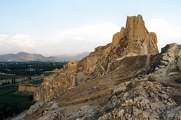
 Van Fortress as seen from the northwest | |
| Coordinates | 38°30′09″N 43°20′24″E / 38.50250°N 43.34000°E |
| Type | Fortress |
| Site information | |
| Open to the public | Yes |
| Condition | Large sections of walls are still standing. |
| Site history | |
| Built | 8th and 7th centuries BC |
| Materials | Unmortared basalt (lower walls) and mud-bricks |
| Demolished | Partially |
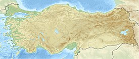
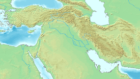
The Fortress of Van (Armenian: Վանի Բերդ, also known as Van Citadel; Kurdish: Kela Wanê; Turkish: Van Kalesi) is a massive stone fortification built by the ancient kingdom of Urartu during the 9th to 7th centuries BC, and is the largest example of its kind. It overlooks the ruins of Tushpa, the ancient Urartian capital during the 9th century, which was centered upon the steep-sided bluff where the fortress now sits. A number of similar fortifications were built throughout the Urartian kingdom, usually cut into hillsides and outcrops in places where modern-day Armenia, Turkey and Iran meet. Successive groups such as the Medes, Achaemenids, Armenians, Parthians, Romans, Sassanid Persians, Byzantines, Arabs, Seljuks, Safavids, Afsharids, Ottomans and Russians each controlled the fortress at one time or another. The ancient fortress is located just west of Van and east of Lake Van in the Van Province of Turkey.
Silva Tipple New Lake led an American expedition to the ruins in 1938-40.[1] Most of the finds and field records from this were lost in the sinking of the S.S. Athenia in 1940.
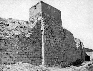
The lower parts of the walls of Van Citadel were constructed of unmortared basalt, while the rest was built from mud bricks.
Such fortresses were used for regional control, rather than as a defense against foreign armies. The ruins of this fortress sit outside the modern city of Van, where they support walls built in the medieval era.[2][full citation needed]
The "Royal Stable"
[edit]At the Van Citadel, there is a "royal stable" (Siršini) of the dimensions of 20 m length, 9 m width and 2,5 m height, carved in rock. Oxen and sheep were held here to be sacrificed for the Urartian gods, according to the inscriptions discovered at the location.[3]
Achaemenid inscription
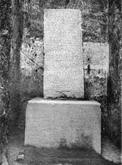
[edit]A stereotyped trilingual inscription of Xerxes the Great from the 5th century BC is inscribed upon a smoothed section of the rock face, some 20 meters (60 feet) above the ground near the fortress. The niche was originally carved out by Xerxes' father, King Darius, but left the surface blank. The inscription survives in near perfect condition and is divided into three columns of 27 lines written in (from left to right) Old Persian, Elamite, and Babylonian.
Gallery
[edit]-
Citadel with the ruins of the city of Tushpa below
-
Van Fortress
-
The walls of the fortress (Russian Archeological Society, 1916)
-
Annals of Sarduri (1915)
-
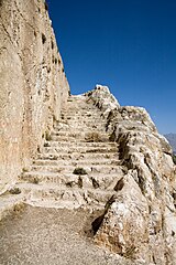
Stairs at the fortress
References
[edit]- ^ Who was who in America. Marquis-Who's Who. 1943. ISBN 978-0-8379-0205-0.
- ^ The Seventy Wonders of the Ancient World
- ^ Çiftçi, Ali (2017). The Socio-Economic Organisation of the Urartian Kingdom. Brill. pp. 113–114. ISBN 9789004347588.

