Arugot: Difference between revisions
Appearance
Content deleted Content added
| (34 intermediate revisions by 18 users not shown) | |||
| Line 1: | Line 1: | ||
{{Short description|Moshav in southern Israel}} |
|||
{{about|the moshav|the wadi (river)|List of rivers of Israel}} |
|||
{{Infobox Israel village |
{{Infobox Israel village |
||
| |
|name = Arugot |
||
|hebname = ערוגות |
|||
| |
|image = Arugot Aerial View.jpg |
||
| |
|imgsize = 250 |
||
| |
|founded = 1949 |
||
| |
|founded_by = [[Poland|Polish]] and [[Romania]]n [[Jews]] |
||
| region = South-central Israel |
|||
| |
|council = [[Be'er Tuvia Regional Council]] |
||
| ⚫ | |||
| industry = Agriculture |
|||
|population = {{Israel populations|Arugot}} |
|||
| ⚫ | |||
|popyear = {{Israel populations|Year}} |
|||
| population = 1,064<ref name="cbs-loc">{{cite web|title=Locality File|year=2011|url=http://cbs.gov.il/ishuvim/ishuv2011/bycode.xls|publisher=[[Israel Central Bureau of Statistics]]|format=XLS|accessdate=February 2, 2013}}</ref> |
|||
|population_footnotes= {{Israel populations|reference}} |
|||
| popyear = 2011 |
|||
|pushpin_map=Israel ashkelon |pushpin_mapsize=250 |
|pushpin_map = Israel ashkelon |pushpin_mapsize=250 |
||
|coordinates = {{coord|31|44|5|N|34|46|15|E|display=inline,title}} |
|||
|latd=31 |latm=44 |lats=4.92 |
|||
| ⚫ | |||
|longd=34 |longm=46 |longs=14.51 |
|||
| ⚫ | |||
}} |
}} |
||
| ⚫ | |||
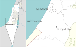
| ⚫ | '''Arugot''' ({{langx|he|עֲרוּגוֹת||garden terraces or beds}}),<ref>[https://biblehub.com/hebrew/6170.htm ''arugah'']. [[Strong's Concordance]] via biblehub.com. Retrieved 6 Oct 2021.</ref> is a [[moshav]] in southern [[Israel]]. Located near [[Kiryat Malakhi]], it falls under the jurisdiction of [[Be'er Tuvia Regional Council]]. In {{Israel populations|Year}} its population was {{Israel populations|Arugot}}.{{Israel populations|reference}} |
||
The moshav was founded in 1949 by [[aliyah|immigrants]] from [[Poland]] and [[Romania]] on the ruins of [[Qastina]] and took its name from Chapter 17, verse 7 of the [[Book of Ezekiel]].<ref name="mapa" /> |
|||
==History== |
|||
The moshav was founded in 1949 by [[aliyah|Jewish immigrants]] from [[Poland]] and [[Romania]] on the land belonging to the depopulated [[Palestinians|Palestinian]] village of [[Qastina]].<ref>{{cite book |last= Khalidi |first= Walid |authorlink= Walid Khalidi |title= All That Remains: The Palestinian Villages Occupied and Depopulated by Israel in 1948 |page=131 |year= 1992 |publisher=[[Institute for Palestine Studies]] |location=[[Washington D.C.]] |isbn= 0-88728-224-5 |url= https://books.google.com/books?id=_By7AAAAIAAJ}}</ref> Its name was taken from the [[Book of Ezekiel]] {{Bibleverse||Ezekiel|17:7|1000|17:7}}.<ref name=mapa>{{Cite book |editor= Elʻazari, Yuval |title= Mapa's concise gazetteer of Israel |page= 435 |publisher= Mapa Publishing |location= Tel-Aviv |year= 2005 |isbn= 965-7184-34-7 |language=he}}</ref> |
|||
==References== |
==References== |
||
{{Reflist}} |
|||
{{reflist|refs= |
|||
<ref name="mapa">{{Cite book |
|||
| publisher = Mapa Publishing |
|||
| isbn = 965-7184-34-7 |
|||
| page = 435 |
|||
| others = Yuval Elʻazari (ed.) |
|||
| title = Mapa's concise gazetteer of Israel |
|||
| location = Tel-Aviv |
|||
| year = 2005 |
|||
}} {{he icon}}</ref> |
|||
}} |
|||
{{Be'er Tuvia Regional Council}} |
{{Be'er Tuvia Regional Council}} |
||
{{Authority control}} |
|||
[[Category:Moshavim]] |
[[Category:Moshavim]] |
||
[[Category:Populated places established in 1949]] |
[[Category:Populated places established in 1949]] |
||
[[Category:Populated places in Southern District (Israel)]] |
[[Category:Populated places in Southern District (Israel)]] |
||
[[Category:1949 establishments in Israel]] |
|||
[[Category:Polish-Jewish culture in Israel]] |
|||
[[Category:Romanian-Jewish culture in Israel]] |
|||
Latest revision as of 04:47, 1 November 2024
Arugot
ערוגות | |
|---|---|
 | |
| Coordinates: 31°44′5″N 34°46′15″E / 31.73472°N 34.77083°E | |
| Country | Israel |
| Council | Be'er Tuvia Regional Council |
| Affiliation | Moshavim Movement |
| Founded | 1949 |
| Founded by | Polish and Romanian Jews |
| Population (2022)[1] | 1,154 |
Arugot (Hebrew: עֲרוּגוֹת, lit. 'garden terraces or beds'),[2] is a moshav in southern Israel. Located near Kiryat Malakhi, it falls under the jurisdiction of Be'er Tuvia Regional Council. In 2022 its population was 1,154.[1]
History
[edit]The moshav was founded in 1949 by Jewish immigrants from Poland and Romania on the land belonging to the depopulated Palestinian village of Qastina.[3] Its name was taken from the Book of Ezekiel 17:7.[4]
References
[edit]- ^ a b "Regional Statistics". Israel Central Bureau of Statistics. Retrieved 21 March 2024.
- ^ arugah. Strong's Concordance via biblehub.com. Retrieved 6 Oct 2021.
- ^ Khalidi, Walid (1992). All That Remains: The Palestinian Villages Occupied and Depopulated by Israel in 1948. Washington D.C.: Institute for Palestine Studies. p. 131. ISBN 0-88728-224-5.
- ^ Elʻazari, Yuval, ed. (2005). Mapa's concise gazetteer of Israel (in Hebrew). Tel-Aviv: Mapa Publishing. p. 435. ISBN 965-7184-34-7.

