Băuțar: Difference between revisions
Appearance
Content deleted Content added
Jnorton7558 (talk | contribs) Removed sitelinks migrated to Wikidata |
|||
| (15 intermediate revisions by 9 users not shown) | |||
| Line 1: | Line 1: | ||
{{Infobox |
{{Infobox Romanian subdivision |
||
|type = commune |
|||
<!--See the Table at Infobox settlement for all fields and descriptions of usage--> |
|||
|county = Caraș-Severin |
|||
<!-- Basic info ----------------> |
|||
|name |
|name = Băuțar |
||
|image_skyline = RO CS Bautar (2).jpg |
|||
|settlement_type =[[Communes of Romania|Commune]] |
|||
| |
|imagesize = |
||
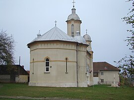
|image_caption = St. Elijah Church in Băuțar |
|||
<!-- images and maps -----------> |
|||
| |
|image_flag = |
||
| |
|flag_size = |
||
| |
|image_seal = |
||
| |
|seal_size = |
||
| |
|image_shield = |
||
| |
|shield_size = |
||
|image_blank_emblem = |
|||
|seal_size = |
|||
|blank_emblem_type = |
|||
|image_shield = |
|||
|blank_emblem_size = |
|||
|shield_size = |
|||
| |
|mapsize = |
||
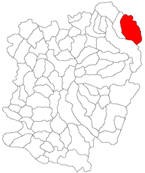
|map_caption = Location in Caraș-Severin County |
|||
|blank_emblem_type = |
|||
|image_map = Bautar jud Caras-Severin.png |
|||
|blank_emblem_size = |
|||
|leader_name = Romeo-Silviu Răduță |
|||
|image_map = Bautar jud Caras-Severin.png |
|||
| |
|leader_party = PNL |
||
|leader_term = 2020–2024 |
|||
|map_caption = Location in Caraș-Severin County |
|||
|established_title = |
|||
|pushpin_map = Romania |
|||
|established_date = |
|||
|pushpin_label_position =above |
|||
|coordinates = {{coord|45|31|N|22|34|E|region:RO|display=it}} |
|||
|pushpin_mapsize = |
|||
|elevation = 407 |
|||
|pushpin_map_caption =Location in Romania |
|||
|elevation_min = |
|||
<!-- Location ------------------> |
|||
| |
|elevation_max = |
||
| |
|area_total = 187.98 |
||
|area_footnotes = |
|||
|subdivision_name = {{flag|Romania}} |
|||
|population_as_of = |
|||
|subdivision_type1 = [[Counties of Romania|County]] |
|||
|population_total = auto |
|||
|subdivision_name1 = [[Caraș-Severin County]] |
|||
|population_footnotes = |
|||
|subdivision_type2 = |
|||
| |
|postal_code = 327015 |
||
|area_code = +40 x55x |
|||
<!-- Politics -----------------> |
|||
|website = {{URL|http://bautar.ro/}} |
|||
|government_footnotes = |
|||
|government_type = |
|||
|leader_title = |
|||
|leader_name = |
|||
|established_title = |
|||
|established_date = |
|||
<!-- Area ---------------------> |
|||
|area_magnitude = |
|||
|unit_pref = |
|||
|area_footnotes = |
|||
|area_total_km2 |
|||
<!-- ALL fields dealing with a measurements are subject to automatic unit conversion--> |
|||
|area_land_km2 = <!--See table @ Template:Infobox settlement for details on automatic unit conversion--> |
|||
|area_water_km2 = |
|||
|area_total_sq_mi = |
|||
|area_land_sq_mi = |
|||
|area_water_sq_mi = |
|||
|area_water_percent = |
|||
|area_metro_km2 = |
|||
|area_metro_sq_mi = |
|||
<!-- Population -----------------------> |
|||
|population_as_of =2002 |
|||
|population_footnotes =<ref>{{ro icon}} [http://recensamant.referinte.transindex.ro/?pg=3&id=752 "Băuțar"], at the [http://adatbank.transindex.ro/ Erdélyi Magyar Adatbank]'s [http://recensamant.referinte.transindex.ro/ ''Recensământ 2002'']; retrieved August 21, 2009</ref> |
|||
|population_note = |
|||
|population_total =2,813 |
|||
|population_density_km2 = |
|||
|population_density_sq_mi = |
|||
|population_metro = |
|||
|population_density_metro_km2 = |
|||
|population_density_metro_sq_mi = |
|||
|population_urban = |
|||
|population_density_urban_km2 = |
|||
|population_density_urban_sq_mi = |
|||
<!-- General information ---------------> |
|||
|timezone =[[Eastern European Time|EET]] |
|||
|utc_offset = +2 |
|||
|timezone_DST = [[Eastern European Summer Time|EEST]] |
|||
|utc_offset_DST = +3 |
|||
|latd=45|latm=31|lats=|latNS=N |
|||
|longd=22|longm=34|longs=|longEW=E |
|||
|elevation_footnotes = <!--for references: use tags--> |
|||
|elevation_m = |
|||
|elevation_ft = |
|||
<!-- Area/postal codes & others --------> |
|||
|postal_code_type = <!-- enter ZIP code, Postcode, Post code, Postal code... --> |
|||
|postal_code = |
|||
|area_code = |
|||
|blank_name = |
|||
|blank_info = |
|||
|blank1_name = |
|||
|blank1_info = |
|||
|website = |
|||
|footnotes = |
|||
}} |
}} |
||
'''Băuțar''' ({{ |
'''Băuțar''' ({{langx|hu|Alsóbaucár}}) is a [[Commune in Romania|commune]] in [[Caraș-Severin County]], western [[Romania]] with a population of 2,229 people as of 2021. It is composed of four villages: Băuțar, Bucova (''Bukova''), Cornișoru (''Strimba''), and Preveciori. |
||
The commune is located in the northeastern part of the county, on the border with [[Hunedoara County]]. It is the only commune in the county located in the historical region of [[Transylvania]]; the rest is in the [[Banat]]. |
|||
The route of the [[Via Transilvanica]] [[long-distance trail]] passes through Băuțar, where the ''Terra Dacica'' section of the trail ends, and the ''Terra Banatica'' section begins.<ref>{{Cite web |title=Terra Banatica {{!}} Via Transilvanica |url=https://www.viatransilvanica.com/en/regions/terra-banatica/ |access-date=June 29, 2024 |website=www.viatransilvanica.com |language=en}}</ref> |
|||
==References== |
==References== |
||
{{Reflist}} |
{{Reflist}} |
||
{{Caraș-Severin County}} |
{{Caraș-Severin County}} |
||
{{coord|45|31|N|22|34|E|display=title|region:RO_type:city_source:GNS-enwiki}} |
|||
{{DEFAULTSORT:Bautar}} |
{{DEFAULTSORT:Bautar}} |
||
[[Category:Communes in |
[[Category:Communes in Caraș-Severin County]] |
||
[[Category:Localities in Transylvania]] |
|||
Latest revision as of 23:04, 2 November 2024
Băuțar | |
|---|---|
 St. Elijah Church in Băuțar | |
 Location in Caraș-Severin County | |
| Coordinates: 45°31′N 22°34′E / 45.517°N 22.567°E | |
| Country | Romania |
| County | Caraș-Severin |
| Government | |
| • Mayor (2020–2024) | Romeo-Silviu Răduță (PNL) |
Area | 187.98 km2 (72.58 sq mi) |
| Elevation | 407 m (1,335 ft) |
| Population (2021-12-01)[1] | 2,229 |
| • Density | 12/km2 (31/sq mi) |
| Time zone | EET/EEST (UTC+2/+3) |
| Postal code | 327015 |
| Area code | +40 x55x |
| Vehicle reg. | CS |
| Website | bautar |
Băuțar (Hungarian: Alsóbaucár) is a commune in Caraș-Severin County, western Romania with a population of 2,229 people as of 2021. It is composed of four villages: Băuțar, Bucova (Bukova), Cornișoru (Strimba), and Preveciori.
The commune is located in the northeastern part of the county, on the border with Hunedoara County. It is the only commune in the county located in the historical region of Transylvania; the rest is in the Banat.
The route of the Via Transilvanica long-distance trail passes through Băuțar, where the Terra Dacica section of the trail ends, and the Terra Banatica section begins.[2]
References
[edit]- ^ "Populaţia rezidentă după grupa de vârstă, pe județe și municipii, orașe, comune, la 1 decembrie 2021" (XLS). National Institute of Statistics.
- ^ "Terra Banatica | Via Transilvanica". www.viatransilvanica.com. Retrieved June 29, 2024.


