Gorla Maggiore: Difference between revisions
Appearance
Content deleted Content added
metric conversions |
Replacing San_Vitale_Church.JPG with File:Gorla_Maggiore_(VA)_-_chiesa_di_San_Vitale_-_02.jpg (by CommonsDelinker because: File renamed:). |
||
| (18 intermediate revisions by 13 users not shown) | |||
| Line 3: | Line 3: | ||
| official_name = Comune di Gorla Maggiore |
| official_name = Comune di Gorla Maggiore |
||
| native_name = |
| native_name = |
||
| image_skyline = |
| image_skyline = File:Gorla Maggiore (VA) - chiesa di San Vitale - 02.jpg |
||
| imagesize = |
| imagesize = |
||
| image_alt = |
| image_alt = |
||
| Line 14: | Line 14: | ||
| pushpin_label_position = |
| pushpin_label_position = |
||
| pushpin_map_alt = |
| pushpin_map_alt = |
||
| coordinates = {{coord|45|40|N|8|53|E|type:city(5,001)_region:IT|display=inline,title}} |
|||
| latd = 45 |latm = 40 |lats = |latNS = N |
|||
| longd = 8 |longm = 53 |longs = |longEW = E |
|||
| coordinates_type = type:city(5,001)_region:IT |
|||
| coordinates_display = title |
|||
| coordinates_footnotes = |
| coordinates_footnotes = |
||
| region = [[Lombardy]] |
| region = [[Lombardy]] |
||
| Line 25: | Line 22: | ||
| mayor = |
| mayor = |
||
| area_footnotes = |
| area_footnotes = |
||
| area_total_km2 = 5. |
| area_total_km2 = 5.16 |
||
| population_total = 4,942 |
|||
| ⚫ | |||
| |
| population_as_of = Dec. 2010 |
||
| ⚫ | |||
| population_as_of = Dec. 2004 |
|||
| pop_density_footnotes = |
|||
| population_demonym = Gorlesi |
| population_demonym = Gorlesi |
||
| elevation_footnotes = |
| elevation_footnotes = |
||
| elevation_m = 254 |
| elevation_m = 254 |
||
| |
| saint = Santa Maria Assunta |
||
| |
| day = 15 of August |
||
| saint = |
|||
| day = |
|||
| postal_code = 21050 |
| postal_code = 21050 |
||
| area_code = 0331 |
| area_code = 0331 |
||
| Line 42: | Line 36: | ||
| footnotes = |
| footnotes = |
||
}} |
}} |
||
'''Gorla Maggiore''' is a ''[[comune]]'' (municipality) in the [[Province of Varese]] in the [[Italy|Italian]] region [[Lombardy]], located about {{convert|30|km|mi}} northwest of [[Milan]] and about {{convert|15|km|mi}} southeast of [[Varese]]. As of 31 December 2004, it |
'''Gorla Maggiore''' is a ''[[comune]]'' (municipality) in the [[Province of Varese]] in the [[Italy|Italian]] region [[Lombardy]], located about {{convert|30|km|mi}} northwest of [[Milan]] and about {{convert|15|km|mi|0}} southeast of [[Varese]]. As of 31 December 2004, it has a population of 4,942 and an area of {{convert|5.3|km2|mi2}}.<ref>{{cite web |last1=TuttItalia |title=Popolazione Gorla Maggiore 2001-2018 |url=https://www.tuttitalia.it/lombardia/78-gorla-maggiore/statistiche/popolazione-andamento-demografico/ |website=TuttItalia |publisher=Gwind srl |access-date=10 October 2019}}</ref> |
||
Gorla Maggiore borders the following municipalities: [[Carbonate (CO)|Carbonate]], [[Fagnano Olona]], [[Gorla Minore]], [[Locate Varesino]], [[Mozzate]], [[Solbiate Olona]]. |
Gorla Maggiore borders the following municipalities: [[Carbonate (CO)|Carbonate]], [[Fagnano Olona]], [[Gorla Minore]], [[Locate Varesino]], [[Mozzate]], [[Solbiate Olona]]. |
||
Since the 1 June 2015 the mayor of the city is Pietro Zappamiglio.<ref>{{cite web |last1=Comune di Gorla Maggiore |title=Sindaco |url=http://www.comunegorlamaggiore.it/Home/AmministrazioneDettagli/Sindaco |website=Comune di Gorla Maggiore |publisher=Comune di Gorla Maggiore |access-date=10 October 2019}}</ref> |
|||
== Demographic evolution == |
|||
== Population history == |
|||
<timeline> |
<timeline> |
||
Colors= |
Colors= |
||
| Line 127: | Line 123: | ||
* [http://www.comunegorlamaggiore.it www.comunegorlamaggiore.it] |
* [http://www.comunegorlamaggiore.it www.comunegorlamaggiore.it] |
||
{{clear}} |
|||
{{Province of Varese}} |
{{Province of Varese}} |
||
{{authority control}} |
|||
[[Category:Cities and towns in Lombardy]] |
[[Category:Cities and towns in Lombardy]] |
||
{{Varese-geo-stub}} |
|||
Latest revision as of 12:04, 3 November 2024
Gorla Maggiore | |
|---|---|
| Comune di Gorla Maggiore | |
 | |
 | |
| Coordinates: 45°40′N 8°53′E / 45.667°N 8.883°E | |
| Country | Italy |
| Region | Lombardy |
| Province | Province of Varese (VA) |
| Area | |
• Total | 5.16 km2 (1.99 sq mi) |
| Elevation | 254 m (833 ft) |
| Population (Dec. 2010)[2] | |
• Total | 4,942 |
| • Density | 960/km2 (2,500/sq mi) |
| Demonym | Gorlesi |
| Time zone | UTC+1 (CET) |
| • Summer (DST) | UTC+2 (CEST) |
| Postal code | 21050 |
| Dialing code | 0331 |
| Patron saint | Santa Maria Assunta |
| Saint day | 15 of August |
| Website | Official website |
Gorla Maggiore is a comune (municipality) in the Province of Varese in the Italian region Lombardy, located about 30 kilometres (19 mi) northwest of Milan and about 15 kilometres (9 mi) southeast of Varese. As of 31 December 2004, it has a population of 4,942 and an area of 5.3 square kilometres (2.0 sq mi).[3]
Gorla Maggiore borders the following municipalities: Carbonate, Fagnano Olona, Gorla Minore, Locate Varesino, Mozzate, Solbiate Olona.
Since the 1 June 2015 the mayor of the city is Pietro Zappamiglio.[4]
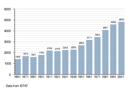
Population history
[edit]
References
[edit]- ^ "Superficie di Comuni Province e Regioni italiane al 9 ottobre 2011". Italian National Institute of Statistics. Retrieved 16 March 2019.
- ^ "Popolazione Residente al 1° Gennaio 2018". Italian National Institute of Statistics. Retrieved 16 March 2019.
- ^ TuttItalia. "Popolazione Gorla Maggiore 2001-2018". TuttItalia. Gwind srl. Retrieved 10 October 2019.
- ^ Comune di Gorla Maggiore. "Sindaco". Comune di Gorla Maggiore. Comune di Gorla Maggiore. Retrieved 10 October 2019.
External links
[edit]


