Nesvík: Difference between revisions
Appearance
Content deleted Content added
mNo edit summary |
|||
| (17 intermediate revisions by 15 users not shown) | |||
| Line 1: | Line 1: | ||
{{Infobox settlement |
|||
[[Image:Nesvik on Faroe map.png|right|thumb|Position of Nesvík in the Faroe Islands]] |
|||
<!-- See Template:Infobox settlement for additional fields and descriptions --> |
|||
'''Nesvík''' is a village on the east coast of the Faroese island of [[Streymoy]], located in the Sunda municipality. Its postal code is FO 437. In 2005 its population was 1. Nesvík is home to a religious camp of the conservative Inner Mission of the national church, and a conference center called Leguhusið í Nesvík. Its name is derived from the Faroese words for ''cape'' and ''bay''. |
|||
| name = Nesvík |
|||
| native_name_lang = fao |
|||
| settlement_type = Village |
|||
<!-- images and maps -----------> |
|||
|image_skyline = Nesvík Faroe Islands 2013.JPG |
|||
|imagesize = 250px |
|||
|image_caption = |
|||
|image_flag = |
|||
|flag_size = |
|||
|image_seal = |
|||
|seal_size = |
|||
|image_shield = |
|||
|shield_size = |
|||
|image_map = |
|||
|mapsize = |
|||
|map_caption = |
|||
|pushpin_map = Faroe Islands <!-- the name of a location map as per http://en.wikipedia.org/wiki/Template:Location_map --> |
|||
|pushpin_label_position = left |
|||
|pushpin_mapsize = 250 |
|||
|pushpin_map_caption = Location in the Faroe Islands |
|||
<!-- Location ------------------> |
|||
|subdivision_type = State |
|||
|subdivision_name = {{flag|Kingdom of Denmark}} |
|||
|subdivision_type1 = Constituent country |
|||
|subdivision_name1 = {{flag|Faroe Islands}} |
|||
|subdivision_type2 = Island |
|||
|subdivision_name2 = [[Streymoy]] |
|||
|subdivision_type3 = Municipality |
|||
|subdivision_name3 = [[Sunda, Faroe Islands|Sunda]] |
|||
|<!-- Politics -----------------> |
|||
|government_footnotes = |
|||
|government_type = |
|||
|leader_title = |
|||
|leader_name = |
|||
|leader_title1 = <!-- for places with, say, both a mayor and a city manager --> |
|||
|leader_name1 = |
|||
|established_title = <!-- Settled --> |
|||
|established_date = |
|||
<!-- Area ---------------------> |
|||
|area_magnitude = |
|||
|unit_pref =Imperial <!--Enter: Imperial, if Imperial (metric) is desired--> |
|||
|area_footnotes = |
|||
|area_total_km2 = <!-- ALL fields dealing with a measurements are subject to automatic unit conversion--> |
|||
|area_land_km2 = <!--See table @ Template:Infobox Settlement for details on automatic unit conversion--> |
|||
<!-- Population -----------------------> |
|||
|population_as_of = 1 May 2023<ref>https://hagstova.fo/en/population/population/population</ref> |
|||
|population_footnotes = |
|||
|population_note = |
|||
|population_total = 0 |
|||
|population_density_km2 = |
|||
|population_density_sq_mi = |
|||
|population_metro = |
|||
|population_density_metro_km2 = |
|||
|population_density_metro_sq_mi = |
|||
|population_blank1_title = |
|||
|population_blank1 = |
|||
|population_density_blank1_km2 = |
|||
|population_density_blank1_sq_mi = |
|||
<!-- General information ---------------> |
|||
|timezone = [[Greenwich Mean Time|GMT]] |
|||
|utc_offset = |
|||
|timezone_DST = [[European Summer Time|EST]] |
|||
|utc_offset_DST = +1 |
|||
|coordinates = {{coord|62|12|35|N|7|0|30|W|region:DK|display=inline,title}} |
|||
|elevation_footnotes = <!--for references: use <ref> </ref> tags--> |
|||
|elevation_m = |
|||
|elevation_ft = |
|||
<!-- Area/postal codes & others --------> |
|||
|postal_code_type = Postal code <!-- enter ZIP code, Postcode, Post code, Postal code... --> |
|||
|postal_code = FO 437 |
|||
|area_code = |
|||
|blank_name = [[Köppen climate classification|Climate]] |
|||
|blank_info = [[Oceanic climate#Subpolar variety (Cfc, Cwc)|Cfc]] |
|||
|blank1_name = |
|||
|blank1_info = |
|||
|website = |
|||
|footnotes = |
|||
}} |
|||
'''Nesvík''' is a village on the east coast of the Faroese island of [[Streymoy]], located in the Sunda municipality. |
|||
[[File:Nesvík Faroe Islands-2.JPG|thumb|left|A Christian Family Holiday Centre in Nesvík, called Leguhúsið í Nesvík]] |
|||
In 2023 its population was 0 with the last inhabitants leaving in 2016. Nesvík is home to a religious camp of the conservative Inner Mission of the national church, and a conference center called Leguhusið í Nesvík. Its name is derived from the Faroese words for ''cape'' and ''bay''. |
|||
==See also== |
==See also== |
||
* [[List of towns in the Faroe Islands]] |
* [[List of towns in the Faroe Islands]] |
||
==References== |
|||
and fuu that shit.... |
|||
{{Reflist}} |
|||
==External links== |
==External links== |
||
* [http://www.gospel.fo Evangeliihúsið in Torshavn], sponsors of activities in Nesvík |
* [https://web.archive.org/web/20070108173819/http://www.gospel.fo/ Evangeliihúsið in Torshavn], sponsors of activities in Nesvík |
||
* [http://faroeislands.dk/pages/NesvikIndex.htm Danish website with photos of Nesvík] |
* [https://web.archive.org/web/20081011031531/http://faroeislands.dk/pages/NesvikIndex.htm Danish website with photos of Nesvík] |
||
{{Authority control}} |
|||
{{coord|62|13|N|7|01|W|display=title|type:city_source:GNS-enwiki}} |
|||
{{DEFAULTSORT:Nesvik}} |
|||
[[Category:Populated places in the Faroe Islands]] |
[[Category:Populated places in the Faroe Islands]] |
||
{{faroes-geo-stub}} |
|||
{{faroes-geo-stub}} |
|||
[[de:Nesvík]] |
|||
[[eo:Nesvík]] |
|||
[[fo:Nesvík]] |
|||
[[hu:Nesvík]] |
|||
[[nl:Nesvík]] |
|||
[[no:Nesvík]] |
|||
[[ro:Nesvík]] |
|||
[[ru:Несвик]] |
|||
Latest revision as of 00:35, 4 November 2024
Nesvík | |
|---|---|
Village | |
 | |
| Coordinates: 62°12′35″N 7°0′30″W / 62.20972°N 7.00833°W | |
| State | |
| Constituent country | |
| Island | Streymoy |
| Municipality | Sunda |
| Population (1 May 2023[1]) | |
• Total | 0 |
| Time zone | GMT |
| • Summer (DST) | UTC+1 (EST) |
| Postal code | FO 437 |
| Climate | Cfc |
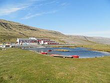
Nesvík is a village on the east coast of the Faroese island of Streymoy, located in the Sunda municipality.

In 2023 its population was 0 with the last inhabitants leaving in 2016. Nesvík is home to a religious camp of the conservative Inner Mission of the national church, and a conference center called Leguhusið í Nesvík. Its name is derived from the Faroese words for cape and bay.
See also
[edit]References
[edit]External links
[edit]- Evangeliihúsið in Torshavn, sponsors of activities in Nesvík
- Danish website with photos of Nesvík

