Aghla Beg: Difference between revisions
Appearance
Content deleted Content added
m Robot - Moving category Mountains of Donegal to Mountains and hills of County Donegal per CFD at Wikipedia:Categories for discussion/Log/2007 March 25. |
|||
| (43 intermediate revisions by 29 users not shown) | |||
| Line 1: | Line 1: | ||
{{Use dmy dates|date=March 2020}} |
|||
{{Infobox |
{{Infobox mountain |
||
| Name = Mullaghanish |
|||
| |
| name = Aghla Beg |
||
| other_name = ''Eachla Beag'' |
|||
| Caption = |
|||
| photo = Fields near Leat Beg - geograph.org.uk - 1429808.jpg |
|||
| Elevation = 603 [[metre|m]] (1,978 [[foot (unit of length)|ft]]) |
|||
| photo_caption = View across Mulroy Bay towards Aghla Beg and Muckish |
|||
| Location = [[County Donegal|Donegal]], {{IRE}} |
|||
| elevation_m = 603 |
|||
| ⚫ | |||
| |
| elevation_ref = |
||
| prominence = |
|||
| Coordinates = {{coor d|55.068710|N|8.055573|W}} |
|||
| listing = [[Marilyn (hill)|Marilyn]] |
|||
| ⚫ | |||
| ⚫ | |||
| Easiest route = |
|||
| ⚫ | |||
| ⚫ | |||
| |
| location = [[County Donegal]], Ireland |
||
| ⚫ | |||
| ⚫ | |||
| map = Ireland |
|||
| ⚫ | |||
| map_caption = Ireland |
|||
| Pronunciation = |
|||
| label_position = right |
|||
| map_size = 240 |
|||
| coordinates = {{coord|55.068710|N|8.055573|W|region:IE_type:mountain|format=dms}} |
|||
| ⚫ | |||
| ⚫ | |||
| easiest_route = |
|||
}} |
}} |
||
'''Aghla Beg''' is a mountain in [[County Donegal]], |
'''Aghla Beg''' ({{langx|ga|Eachla Beag}}) is a mountain in [[County Donegal]], Ireland. Of its two summits, one has a height of {{convert|564|m}}, and the other, '''Aghla Beg South Top''' {{convert|602|m}}. |
||
== Geography == |
|||
| ⚫ | |||
[[File:Lough Feeane from Aghla More - geograph.org.uk - 1052986.jpg|thumb|left|View from [[Aghla More]] across Lough Feeane towards the two summits of Aghla Beg. Behind them, [[Muckish]] is visible.]] |
|||
The mountain is the third-most northern and fifth-highest of the mountain chain, called the ''[[Seven Sisters, Donegal|Seven Sisters]]'' by locals: [[Muckish]], [[Crocknalaragagh]], Aghla Beg, [[Ardloughnabrackbaddy]], [[Aghla More]], [[Mackoght]] (also known as 'little Errigal') and [[Errigal]]. The Seven Sisters are part of the [[Derryveagh Mountains]]. |
|||
== External links == |
|||
* [http://mountainviews.ie/mv/index.php?mtnindex=266 Aghla Beg on MountainViews.ie] |
|||
| ⚫ | |||
{{Authority control}} |
|||
| ⚫ | |||
[[Category:Marilyns of Ireland]] |
[[Category:Marilyns of Ireland]] |
||
[[Category:Mountains and hills of County Donegal]] |
|||
[[Category:Mountains under 1000 metres]] |
|||
| ⚫ | |||
Latest revision as of 07:33, 6 November 2024
| Aghla Beg | |
|---|---|
| Eachla Beag | |
 View across Mulroy Bay towards Aghla Beg and Muckish | |
| Highest point | |
| Elevation | 603 m (1,978 ft) |
| Listing | Marilyn |
| Coordinates | 55°04′07″N 8°03′20″W / 55.068710°N 8.055573°W |
| Naming | |
| English translation | small look-out |
| Language of name | Irish |
| Geography | |
| Location | County Donegal, Ireland |
| Parent range | Seven Sisters |
| OSI/OSNI grid | B965246 |
| Topo map | OSi Discovery 2 |
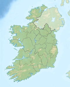
Aghla Beg (Irish: Eachla Beag) is a mountain in County Donegal, Ireland. Of its two summits, one has a height of 564 metres (1,850 ft), and the other, Aghla Beg South Top 602 metres (1,975 ft).
Geography
[edit]
The mountain is the third-most northern and fifth-highest of the mountain chain, called the Seven Sisters by locals: Muckish, Crocknalaragagh, Aghla Beg, Ardloughnabrackbaddy, Aghla More, Mackoght (also known as 'little Errigal') and Errigal. The Seven Sisters are part of the Derryveagh Mountains.
External links
[edit]


