Podgorje, Slovenj Gradec: Difference between revisions
Appearance
Content deleted Content added
m Disperse category and/or GFs using AWB |
|||
| (16 intermediate revisions by 9 users not shown) | |||
| Line 1: | Line 1: | ||
{{Infobox settlement |
{{Infobox settlement |
||
|official_name = Podgorje |
|official_name = Podgorje |
||
|other_name = |
|other_name = |
||
|native_name = |
|native_name = |
||
|nickname = |
|nickname = |
||
|settlement_type = |
|settlement_type = Village |
||
|motto = |
|motto = |
||
|image_skyline = |
|image_skyline = |
||
|imagesize = |
|imagesize = 250px |
||
|image_caption = |
|image_caption = |
||
|image_flag = |
|image_flag = |
||
|flag_size = |
|flag_size = |
||
| Line 28: | Line 28: | ||
|dot_map_caption = |
|dot_map_caption = |
||
|dot_x = |dot_y = |
|dot_x = |dot_y = |
||
|pushpin_map |
||pushpin_map = Slovenia |
||
|pushpin_label_position =bottom |
|pushpin_label_position = bottom |
||
|pushpin_map_caption =Location in Slovenia |
|pushpin_map_caption = Location in Slovenia |
||
|subdivision_type = Country |
|subdivision_type = Country |
||
|subdivision_name = [[ |
|subdivision_name = [[File:Flag of Slovenia.svg|25px]] [[Slovenia]] |
||
|subdivision_type1 = |
|subdivision_type1 = Traditional region |
||
|subdivision_name1 = [[ |
|subdivision_name1 = [[Lower Styria|Styria]] |
||
|subdivision_type2 = [[ |
|subdivision_type2 = [[Statistical regions of Slovenia|Statistical region]] |
||
|subdivision_name2 = [[ |
|subdivision_name2 = [[Carinthia Statistical Region|Carinthia]] |
||
|subdivision_type3 = |
|subdivision_type3 = [[Municipalities of Slovenia|Municipality]] |
||
|subdivision_name3 = |
|subdivision_name3 = [[City Municipality of Slovenj Gradec|Slovenj Gradec]] |
||
|subdivision_type4 = |
|subdivision_type4 = |
||
|subdivision_name4 = |
|subdivision_name4 = |
||
| Line 57: | Line 57: | ||
|established_date3 = |
|established_date3 = |
||
|area_magnitude = |
|area_magnitude = |
||
|unit_pref = |
|unit_pref = |
||
|area_footnotes = |
|area_footnotes = |
||
|area_total_km2 = |
|area_total_km2 = 18.73 |
||
|area_land_km2 = |
|area_land_km2 = |
||
|area_water_km2 = |
|area_water_km2 = |
||
| Line 73: | Line 73: | ||
|area_blank1_km2 = |
|area_blank1_km2 = |
||
|area_blank1_sq_mi = |
|area_blank1_sq_mi = |
||
|population_as_of =2002 |
|population_as_of = 2002 |
||
|population_footnotes = |
|population_footnotes = |
||
|population_note = |
|population_note = |
||
|population_total =947 |
|population_total = 947 |
||
|population_density_km2 = |
|population_density_km2 = |
||
|population_density_sq_mi = |
|population_density_sq_mi = |
||
| Line 95: | Line 95: | ||
|timezone_DST = |
|timezone_DST = |
||
|utc_offset_DST = |
|utc_offset_DST = |
||
|coordinates = {{coord|46|28|4.81|N|15|5|23.95|E|region:SI|display=inline,title}} |
|||
|latd=|latm= |lats= |latNS=N |
|||
|longd=|longm= |longs=|longEW=E |
|||
|elevation_footnotes = |
|elevation_footnotes = |
||
|elevation_m = |
|elevation_m = 444.6 |
||
|elevation_ft = |
|elevation_ft = |
||
|postal_code_type = |
|postal_code_type = |
||
| Line 108: | Line 107: | ||
|blank1_info = |
|blank1_info = |
||
|website = |
|website = |
||
|footnotes = |
|footnotes = <ref>[http://www.stat.si/eng/index.asp Statistical Office of the Republic of Slovenia]</ref> |
||
}} |
}} |
||
'''Podgorje''' ({{IPA|sl|ˈpoːdɡɔɾjɛ|pron}}) is a settlement in the [[City Municipality of Slovenj Gradec]] in northern [[Slovenia]]. The area is part of the traditional region of [[Lower Styria|Styria]]. The entire municipality is now included in the [[Carinthia Statistical Region]].<ref>[http://www.slovenj-gradec.si Slovenj Gradec municipal site]</ref> |
|||
'''Podgorje, Slovenj Gradec''' is a [[village]] in northern [[Slovenia]] in the municipality of [[Slovenj Gradec]]. Population 947. |
|||
<ref>[http://www.stat.si/eng/index.asp Statistical Office of the Republic of Slovenia]</ref> |
|||
The [[parish church]] in the settlement is dedicated to [[Ulrich of Augsburg|Saint Ulrich]] ({{langx|sl|sveti Urh}}) and belongs to the [[Roman Catholic Archdiocese of Maribor]]. It dates to the late 15th century.<ref>[http://rkd.situla.org/ Slovenian Ministry of Culture register of national heritage] reference number ešd 3256</ref> A second [[church (building)|church]] built on a hill west of the settlement is dedicated to the [[Holy Spirit]] ({{langx|sl|Sveti Duh}}) and was built in 1459.<ref>[http://rkd.situla.org/ Slovenian Ministry of Culture register of national heritage] reference number ešd 3257</ref> |
|||
==References== |
==References== |
||
| Line 117: | Line 117: | ||
==External links== |
==External links== |
||
*[ |
*[https://www.geopedia.world/#T12_L362_F2473:4491_x1676702.9591026818_y5853706.932837296_s13_b2345 Podgorje on Geopedia] |
||
*[http://www.maplandia.com/ Search satellite map at Maplandia.com] |
|||
{{Slovenj Gradec}} |
{{Slovenj Gradec}} |
||
{{DEFAULTSORT:Podgorje}} |
|||
{{Coord|46|28|4|N|15|5|23|E|type:city_region:SI_source:nlwiki|display=title}} |
|||
| ⚫ | |||
| ⚫ | |||
[[Category:Slovenj Gradec]] |
[[Category:Slovenj Gradec]] |
||
{{SlovenjGradec-geo-stub}} |
{{SlovenjGradec-geo-stub}} |
||
[[nl:Podgorje (Slovenj Gradec)]] |
|||
[[sl:Podgorje, Slovenj Gradec]] |
|||
Latest revision as of 01:19, 7 November 2024
Podgorje | |
|---|---|
Village | |
| Coordinates: 46°28′4.81″N 15°5′23.95″E / 46.4680028°N 15.0899861°E | |
| Country | |
| Traditional region | Styria |
| Statistical region | Carinthia |
| Municipality | Slovenj Gradec |
| Area | |
• Total | 18.73 km2 (7.23 sq mi) |
| Elevation | 444.6 m (1,458.7 ft) |
| Population (2002) | |
• Total | 947 |
| [1] | |
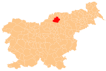
Podgorje (pronounced [ˈpoːdɡɔɾjɛ]) is a settlement in the City Municipality of Slovenj Gradec in northern Slovenia. The area is part of the traditional region of Styria. The entire municipality is now included in the Carinthia Statistical Region.[2]
The parish church in the settlement is dedicated to Saint Ulrich (Slovene: sveti Urh) and belongs to the Roman Catholic Archdiocese of Maribor. It dates to the late 15th century.[3] A second church built on a hill west of the settlement is dedicated to the Holy Spirit (Slovene: Sveti Duh) and was built in 1459.[4]
References
[edit]- ^ Statistical Office of the Republic of Slovenia
- ^ Slovenj Gradec municipal site
- ^ Slovenian Ministry of Culture register of national heritage reference number ešd 3256
- ^ Slovenian Ministry of Culture register of national heritage reference number ešd 3257
External links
[edit]


