Geghashen: Difference between revisions
Appearance
Content deleted Content added
m Robot - Moving category Cities, towns and villages in Kotayk to Populated places in Kotayk per CFD at Wikipedia:Categories for discussion/Log/2010 May 28. |
No edit summary |
||
| (18 intermediate revisions by 15 users not shown) | |||
| Line 1: | Line 1: | ||
{{Infobox settlement |
{{Infobox settlement |
||
|official_name = Geghashen |
|official_name = Geghashen |
||
|native_name =Գեղաշեն |
|native_name = Գեղաշեն |
||
| |
|image_skyline = Գեղաշեն.jpg |
||
| |
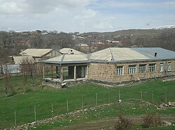
|image_caption = Geghashen |
||
|pushpin_map = Armenia |
|||
|mapsize = 150px |
|||
|subdivision_type = Country |
|subdivision_type = Country |
||
|subdivision_name = [[Armenia]] |
|subdivision_name = [[Armenia]] |
||
| Line 12: | Line 14: | ||
|established_title = |
|established_title = |
||
|established_date = |
|established_date = |
||
|area_total_km2 |
|area_total_km2 = |
||
|area_footnotes |
|area_footnotes = |
||
|population_as_of |
|population_as_of = 2011 |
||
|population_total = 3,937<ref>{{cite web|url=https://citypopulation.de/en/armenia/kotayk/|title=Kotayk (Armenia): Towns and Villages in Municipalities|website=www.citypopulation.de|access-date=2024-11-07}}</ref> |
|||
|population_total =3982 |
|||
|population_density_km2 |
|population_density_km2 = |
||
|timezone = |
|timezone = |
||
|utc_offset = |
|utc_offset = |
||
|timezone_DST = |
|timezone_DST = |
||
|utc_offset_DST = |
|utc_offset_DST = |
||
|coordinates = {{coord|40|14|04|N|44|43|37|E|region:AM|display=inline}} |
|||
|latd=40 |latm= 14|lats=04 |latNS=N |
|||
|longd=44|longm=43 |longs=37 |longEW=E |
|||
|elevation_m = |
|elevation_m = |
||
|area_code = |
|area_code = |
||
| Line 28: | Line 29: | ||
}} |
}} |
||
{{coord|40|14|04|N|44|43|37|E|display=title}} |
{{coord|40|14|04|N|44|43|37|E|display=title}} |
||
'''Geghashen''' ({{ |
'''Geghashen''' ({{langx|hy|Գեղաշեն}}, until 1935 '''Chatkran'''; until 1967 '''Hrazdan'''<ref>Kiesling, ''Rediscovering Armenia'', p. 59, available online at the [http://yerevan.usembassy.gov/armenia.pdf US embassy to Armenia's website] {{webarchive |url=https://web.archive.org/web/20080626205330/http://yerevan.usembassy.gov/armenia.pdf |date=June 26, 2008 }}</ref>) is a [[village]] in the [[Kotayk Province]] of [[Armenia]]. |
||
== See also == |
|||
*[[Kotayk Province]] |
|||
== References == |
== References == |
||
{{reflist}} |
{{reflist}} |
||
*{{GEOnet2|32FA881E6B103774E0440003BA962ED3}} |
|||
*[http://world-gazetteer.com/wg.php?x=&men=gcis&lng=en&des=wg&srt=npan&col=abcdefghinoq&msz=1500&geo=-17 World Gazeteer: Armenia] – World-Gazetteer.com |
|||
*{{ArmenianCensus|178}} |
|||
{{Kotayk}} |
|||
| ⚫ | |||
| ⚫ | |||
{{Kotayk-geo-stub}} |
{{Kotayk-geo-stub}} |
||
[[fr:Geghashen]] |
|||
Latest revision as of 07:29, 7 November 2024
Geghashen
Գեղաշեն | |
|---|---|
 Geghashen | |
| Coordinates: 40°14′04″N 44°43′37″E / 40.23444°N 44.72694°E | |
| Country | Armenia |
| Province | Kotayk |
| Population (2011) | |
• Total | 3,937[1] |
40°14′04″N 44°43′37″E / 40.23444°N 44.72694°E Geghashen (Armenian: Գեղաշեն, until 1935 Chatkran; until 1967 Hrazdan[2]) is a village in the Kotayk Province of Armenia.
See also
[edit]References
[edit]- ^ "Kotayk (Armenia): Towns and Villages in Municipalities". www.citypopulation.de. Retrieved 2024-11-07.
- ^ Kiesling, Rediscovering Armenia, p. 59, available online at the US embassy to Armenia's website Archived June 26, 2008, at the Wayback Machine


