Varoš, Prilep: Difference between revisions
Appearance
Content deleted Content added
| (17 intermediate revisions by 12 users not shown) | |||
| Line 1: | Line 1: | ||
{{ |
{{more citations needed|date=August 2016}} |
||
{{Infobox settlement |
{{Infobox settlement |
||
<!-- See Template:Infobox settlement for additional fields and descriptions --> |
<!-- See Template:Infobox settlement for additional fields and descriptions -->| name = Varoš |
||
| |
| native_name = Варош |
||
| |
| native_name_lang = mk |
||
| |
| settlement_type = Village |
||
| |
| image_skyline = File:72 1 Варош.jpg |
||
| |
| image_alt = |
||
| |
| image_caption = Aerial view of the village |
||
| |
| image_flag = |
||
| |
| flag_alt = |
||
| |
| image_seal = |
||
| |
| seal_alt = |
||
| |
| image_shield = |
||
| |
| shield_alt = |
||
| |
| nickname = |
||
| |
| motto = |
||
| |
| image_map = |
||
| |
| map_alt = |
||
| |
| map_caption = |
||
| |
| pushpin_map = |
||
| |
| pushpin_label_position = |
||
| ⚫ | |||
| pushpin_label_position = |
|||
| |
| pushpin_map_caption = |
||
| |
| coordinates = |
||
| |
| coor_pinpoint = |
||
| |
| coordinates_footnotes = |
||
| |
| subdivision_type = Country |
||
| |
| subdivision_name = [[North Macedonia]] |
||
| subdivision_type1 = Municipality |
|||
| coordinates_display = inline,title |
|||
| ⚫ | |||
| coordinates_footnotes = |
|||
| |
| subdivision_type2 = |
||
| |
| subdivision_name2 = |
||
| |
| subdivision_type3 = |
||
| ⚫ | |||
| ⚫ | |||
| |
| established_title = |
||
| |
| established_date = |
||
| |
| founder = |
||
| |
| seat_type = |
||
| |
| seat = |
||
| |
| government_footnotes = |
||
| |
| leader_party = |
||
| |
| leader_title = |
||
| |
| leader_name = |
||
| ⚫ | |||
| government_footnotes = |
|||
| |
| area_footnotes = |
||
| |
| area_total_km2 = |
||
| |
| area_land_km2 = |
||
| |
| area_water_km2 = |
||
| |
| area_water_percent = |
||
| |
| area_note = |
||
| |
| elevation_footnotes = |
||
| |
| elevation_m = 650 |
||
| |
| population_footnotes = |
||
| |
| population_total = |
||
| |
| population_as_of = 2002 |
||
| |
| population_density_km2 = auto |
||
| |
| population_demonym = |
||
| |
| population_note = |
||
| timezone1 = [[Central European Time|CET]] |
|||
| population_as_of = 2002 |
|||
| utc_offset1 = +1 |
|||
| population_density_km2 = auto |
|||
| |
| timezone1_DST = |
||
| |
| utc_offset1_DST = |
||
| |
| postal_code_type = |
||
| |
| postal_code = |
||
| |
| area_code_type = |
||
| |
| area_code = +389/48/4XXXXX |
||
| |
| iso_code = |
||
| |
| website = <!-- {{URL|example.com}} --> |
||
| |
| footnotes = |
||
| |
| official_name = |
||
| ⚫ | |||
| ⚫ | |||
| ⚫ | |||
}} |
}} |
||
'''Varoš''' is a part of [[Prilep]], 20 years ago, this used to be a village, until it joined Prilep, making it the only former village in [[Prilep Municipality|Prilep]] to be inhabited. |
'''Varoš''' ({{langx|mk|Варош}}) is a part of [[Prilep]],<ref>{{Cite web|url=https://www.google.co.uk/maps/place/Varosh,+7501,+Macedonia+(FYROM)/@41.3569681,21.5244967,15z/data=!3m1!4b1!4m5!3m4!1s0x1356ebced55110b7:0x621c2b4d790dc336!8m2!3d41.3570009!4d21.5326694|title=Varosh · North Macedonia}}</ref> 20 years ago, this used to be a village, until it joined Prilep, making it the only former village in [[Prilep Municipality|Prilep]] to be inhabited. |
||
It is said that Varoš had 77 churches at the end of the 18th century, with just seven surviving to the end of the 19th century.<ref>{{cite book |title=Macedonia A Voyage through History (Vol. 1, From Ancient Times to the Ottoman Invasions), Volume 1 |url=https://books.google.com/books?id=eib5DAAAQBAJ&dq=marko%27s+towers+prilep&pg=PA360 |page=361 |author=Michael R. Palairet |isbn=9781443888431 |publisher=Cambridge Scholars Publishing }}</ref> |
|||
{{Uncategorized|date=May 2016}} |
|||
==References== |
|||
{{Reflist}} |
|||
{{coord|41.3567|N|21.5322|E|source:wikidata|display=title}} |
|||
{{DEFAULTSORT:Varos (Prilep)}} |
|||
[[Category:Prilep]] |
|||
{{Prilep-geo-stub}} |
|||
Latest revision as of 19:24, 9 November 2024
This article needs additional citations for verification. (August 2016) |
Varoš
Варош | |
|---|---|
Village | |
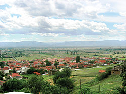
 Aerial view of the village | |
 | |
| Country | North Macedonia |
| Municipality | Prilep |
| Elevation | 650 m (2,130 ft) |
| Time zone | UTC+1 (CET) |
| Area code | +389/48/4XXXXX |
Varoš (Macedonian: Варош) is a part of Prilep,[1] 20 years ago, this used to be a village, until it joined Prilep, making it the only former village in Prilep to be inhabited.
It is said that Varoš had 77 churches at the end of the 18th century, with just seven surviving to the end of the 19th century.[2]
References
[edit]- ^ "Varosh · North Macedonia".
- ^ Michael R. Palairet. Macedonia A Voyage through History (Vol. 1, From Ancient Times to the Ottoman Invasions), Volume 1. Cambridge Scholars Publishing. p. 361. ISBN 9781443888431.
41°21′24″N 21°31′56″E / 41.3567°N 21.5322°E
