Ölziit, Arkhangai: Difference between revisions
Appearance
Content deleted Content added
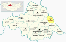
add map per WP:MAPS |
|||
| Line 86: | Line 86: | ||
| footnotes = |
| footnotes = |
||
}} |
}} |
||
'''Ölziit''' ({{ |
'''Ölziit''' ({{langx|mn|Өлзийт}}, Blessed) is a [[Sums of Mongolia|sum]] (district) of [[Arkhangai Province]] in central [[Mongolia]]. There is a concrete bridge over the [[Orkhon River]] just east of the sum center. In 2009, its population was 3,102.<ref name="Stat2009">[http://www.statis.mn/portal/content_files/comppmedia/cxls0x1523.xls Dec. 31 2009 estimation. Arkhangai Aimag Statistical Service] {{webarchive|url=https://web.archive.org/web/20110722221815/http://www.statis.mn/portal/content_files/comppmedia/cxls0x1523.xls|date=July 22, 2011}}</ref> |
||
== References == |
== References == |
||
Latest revision as of 01:28, 10 November 2024
Ölziit District
Өлзийт сум ᠥᠯᠵᠡᠶᠢᠲᠦᠰᠤᠮᠤ | |
|---|---|
 Ölziit Disrict in Arkhangai Province | |
| Country | Mongolia |
| Province | Arkhangai Province |
| Area | |
• Total | 1,700 km2 (700 sq mi) |
| Time zone | UTC+8 (UTC + 8) |
Ölziit (Mongolian: Өлзийт, Blessed) is a sum (district) of Arkhangai Province in central Mongolia. There is a concrete bridge over the Orkhon River just east of the sum center. In 2009, its population was 3,102.[1]
References
[edit]- ^ Dec. 31 2009 estimation. Arkhangai Aimag Statistical Service Archived July 22, 2011, at the Wayback Machine
48°06′02″N 102°33′30″E / 48.10056°N 102.55833°E

