Chuya Steppe: Difference between revisions
Appearance
Content deleted Content added
bold formatting title using AWB |
|||
| (37 intermediate revisions by 28 users not shown) | |||
| Line 1: | Line 1: | ||
{{unreferenced|date=January 2016}} |
|||
| ⚫ | |||
{{Infobox landform |
|||
| ⚫ | |||
| water = |
|||
| ⚫ | |||
| name = Chuya Steppe |
|||
| other_name = |
|||
| type = [[Depression (geology)|Depression]] |
|||
| photo = Chuja steppe.jpg |
|||
| photo_width = |
|||
| photo_alt = |
|||
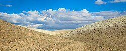
| photo_caption = Chuja steppe landscape |
|||
<!-- map --> |
|||
| map = Russia Altai Republic#Russia |
|||
| relief = yes |
|||
| map_image = |
|||
| map_caption = |
|||
<!-- location --> |
|||
| location = |
|||
|coordinates = {{coord|source:Wikidata|format=dms|display=it}} |
|||
| coordinates_ref = |
|||
| range = |
|||
| part_of = |
|||
| water_bodies = |
|||
| elevation_ft = <!-- or |elevation_m = --> |
|||
| elevation_ref = |
|||
| surface_elevation_ft = <!-- or |surface_elevation_m = --> |
|||
| surface_elevation_ref = |
|||
| highest_point = |
|||
| highest_elevation = |
|||
| highest_coords = |
|||
| length = |
|||
| width = |
|||
| area = |
|||
| depth = |
|||
| drop = |
|||
| formed_by = |
|||
| geology = <!-- or |type = --> |
|||
| age = |
|||
| orogeny = |
|||
| volcanic_arc/belt = |
|||
| volcanic_arc = |
|||
| volcanic_belt = |
|||
| volcanic_field = |
|||
| eruption = |
|||
| last_eruption = |
|||
| topo = |
|||
| operator = |
|||
| designation = |
|||
| free_label_1 = |
|||
| free_data_1 = |
|||
| free_label_2 = |
|||
| free_data_2 = |
|||
| website = |
|||
| embed = |
|||
}} |
|||
| ⚫ | |||
==Earthquake Activity== |
|||
In September 2003, a major earthquake occurred in the Chuya basin which caused regional devastation. Major movement considered to have occurred on the Chuya thrust fault caused this earthquake, of magnitude 7.3. The [[USGS]] estimates that this caused $10.6 million damage. |
|||
| ⚫ | |||
[[File:Jazator Jul 046.jpg|thumb|left|270px|[[Yurt]]s in the steppe]] |
|||
| ⚫ | |||
==Geology== |
|||
The Chuya Steppe is filled with [[Cenozoic]] sediments, derived from the surrounding mountains of the [[Chuya Belki]]. |
|||
==Seismicity== |
|||
The 7.3 {{M|w}} [[2003 Altai earthquake|Altai earthquake]] shook [[South Central Siberia]] with a maximum [[Mercalli intensity scale|Mercalli intensity]] of X (''Extreme''), causing [[United States dollar|$]]10.6–33 million in damage, three deaths, and five injuries. |
|||
[[Category:Grasslands of Russia]] |
|||
[[Category:Geography of Siberia]] |
|||
[[Category:Natural history of Siberia]] |
|||
[[Category:Depressions of Russia]] |
|||
[[Category:Temperate grasslands, savannas, and shrublands]] |
|||
[[Category:Geography of the Altai Republic]] |
|||
{{Siberia-geo-stub}} |
|||
Latest revision as of 06:43, 10 November 2024
Chuya Steppe | |
|---|---|
 Chuja steppe landscape | |
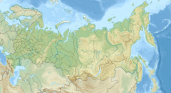
| Coordinates: 49°55′N 88°30′E / 49.92°N 88.5°E |
The Chuya Steppe (Russian: Чуйская степь) in the Siberian Altai Mountains is a depression formed by tectonic movement of major faults in the Earth's crust. Its name comes from the large river which runs through the steppe, the Chuya River.
Major settlements
[edit]
Kosh-Agach is a major village in the north of the steppe. Other large settlements include Chaganuzun and Beltir.
Geology
[edit]The Chuya Steppe is filled with Cenozoic sediments, derived from the surrounding mountains of the Chuya Belki.
Seismicity
[edit]The 7.3 Mw Altai earthquake shook South Central Siberia with a maximum Mercalli intensity of X (Extreme), causing $10.6–33 million in damage, three deaths, and five injuries.


