Beli, Kočani: Difference between revisions
| (12 intermediate revisions by 10 users not shown) | |||
| Line 1: | Line 1: | ||
{{Infobox settlement |
|||
| ⚫ | |||
| name = Beli |
|||
| native_name = Бели |
|||
| settlement_type = Village |
|||
| image_skyline = Selo Beli.JPG |
|||
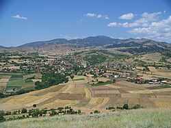
| image_caption = View of the village |
|||
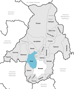
| image_map = Бели во Општина Кочани.svg |
|||
|pushpin_map = North Macedonia |
|||
|pushpin_label_position = left<!-- the position of the pushpin label: left, right, top, bottom, none --> |
|||
|pushpin_map_caption = Location within North Macedonia |
|||
|pushpin_mapsize = |
|||
<!-- Location ------------------> |
|||
| coordinates = {{coord|41|55|39|N|22|22|50|E}} |
|||
|subdivision_type = [[List of sovereign states|Country]] |
|||
|subdivision_name = {{NMK}} |
|||
|subdivision_type1 = [[Statistical Regions of North Macedonia|Region]] |
|||
|subdivision_name1 = [[File:Logo of Eastern Region, North Macedonia.svg|15px]] [[Eastern Statistical Region|Eastern]] |
|||
|subdivision_type2 = [[Municipalities of North Macedonia|Municipality]] |
|||
|subdivision_name2 = [[File:Coat of arms of Kočani Municipality.svg|15px]] [[Municipality of Kočani|Kočani]] |
|||
| elevation_m = 524 |
|||
| population_total = 354 |
|||
| postal_code = 2300 |
|||
| area_code = (0)33 |
|||
<!-- General information ---------------> |
|||
|timezone = [[Central European Time|CET]] |
|||
|utc_offset = +1 |
|||
|timezone_DST = [[Central European Summer Time|CEST]] |
|||
|utc_offset_DST = +2 |
|||
}} |
|||
| ⚫ | |||
== Geography and location == |
== Geography and location == |
||
The village is located foothills of the [[Osogovo|Osogov Mountains]], around 2 kilometers northeast of Kočani. The village is reached via Regional Route 1309 which leads to Ponikva. The road that leads into Beli is also the same road that leads to Nivičani, Pantelej, and [[Rajčani]]. |
The village is located foothills of the [[Osogovo|Osogov Mountains]], around 2 kilometers northeast of Kočani. The village is reached via Regional Route 1309 which leads to Ponikva. The road that leads into Beli is also the same road that leads to Nivičani, Pantelej, and [[Rajčani]]. |
||
== History == |
== History == |
||
| Line 8: | Line 38: | ||
== Demographics == |
== Demographics == |
||
According to the statistician [[Vasil Kanchov|Vasil Kančov]], around 400 people lived in Beli around 1900. All were [[ |
According to the statistician [[Vasil Kanchov|Vasil Kančov]], around 400 people lived in Beli around 1900. All were [[Bulgarians]]. |
||
According to the secretary of the [[Bulgarian Exarchate]] Dimitar Mishev, Beli had 576 |
According to the secretary of the [[Bulgarian Exarchate]] Dimitar Mishev, Beli had 576 Bulgarian residents. |
||
According to the |
According to the national census of Macedonia in 2002, the village had 466 residents, all Macedonian.<ref name = Statisticaloffice>Macedonian Census (2002), [http://www.stat.gov.mk/publikacii/knigaX.pdf ''Book 5 - Total population according to the Ethnic Affiliation, Mother Tongue and Religion''], The State Statistical Office, Skopje, 2002, p. 118.</ref> |
||
As of 2021, the village of Beli has 354 inhabitants and the ethnic composition was the following:<ref name="Statistical Office">{{cite web |title=Archived |url=http://makstat.stat.gov.mk/PXWeb/pxweb/en/MakStat/MakStat__Popisi__Popis2021__NaselenieVkupno__PodatociNaselenie/T1503P21.px/table/tableViewLayout2/?rxid=46ee0f64-2992-4b45-a2d9-cb4e5f7ec5ef |website=makstat.stat.gov.mk |access-date=26 April 2023 |archive-url=https://web.archive.org/web/20221225143154/http://makstat.stat.gov.mk/PXWeb/pxweb/en/MakStat/MakStat__Popisi__Popis2021__NaselenieVkupno__PodatociNaselenie/T1503P21.px/table/tableViewLayout2/?rxid=46ee0f64-2992-4b45-a2d9-cb4e5f7ec5ef |archive-date=December 25, 2022}}{{dl|date=April 2023}}</ref> |
|||
* [[Macedonians (ethnic group)|Macedonians]] – 342 |
|||
* Person without Data - 12 |
|||
The table below shows the population in each census year: |
The table below shows the population in each census year: |
||
{| class="wikitable" |
{| class="wikitable" |
||
| Line 44: | Line 78: | ||
{{reflist}} |
{{reflist}} |
||
{{Kočani Municipality}} |
|||
[[Category:Populated places established in the 9th century]] |
[[Category:Populated places established in the 9th century]] |
||
Latest revision as of 10:16, 10 November 2024
Beli
Бели | |
|---|---|
Village | |
 View of the village | |
 | |
| Coordinates: 41°55′39″N 22°22′50″E / 41.92750°N 22.38056°E | |
| Country | |
| Region | |
| Municipality | |
| Elevation | 524 m (1,719 ft) |
| Population | |
• Total | 354 |
| Time zone | UTC+1 (CET) |
| • Summer (DST) | UTC+2 (CEST) |
| Area code | (0)33 |
Beli (Macedonian: Бели) is a village in the municipality of Kočani, North Macedonia, near the city of Kočani.
Geography and location
[edit]The village is located foothills of the Osogov Mountains, around 2 kilometers northeast of Kočani. The village is reached via Regional Route 1309 which leads to Ponikva. The road that leads into Beli is also the same road that leads to Nivičani, Pantelej, and Rajčani.
History
[edit]It is believed that the village dates from the middle of the 9th century and that it was founded by Slavs who a few decades later accepted Christianity. In the 19th century, Beli was a part of the Kočani Kaza of the Ottoman Empire.
Demographics
[edit]According to the statistician Vasil Kančov, around 400 people lived in Beli around 1900. All were Bulgarians.
According to the secretary of the Bulgarian Exarchate Dimitar Mishev, Beli had 576 Bulgarian residents.
According to the national census of Macedonia in 2002, the village had 466 residents, all Macedonian.[1]
As of 2021, the village of Beli has 354 inhabitants and the ethnic composition was the following:[2]
- Macedonians – 342
- Person without Data - 12
The table below shows the population in each census year:
| Year | 1900 | 1905 | 1948 | 1953 | 1961 | 1971 | 1981 | 1991 | 1994 | 2002 |
|---|---|---|---|---|---|---|---|---|---|---|
| Population | 400[3] | 576[4] | 706 | 778 | 846 | 726 | 486 | 467 | 454 | 466 |
References
[edit]- ^ Macedonian Census (2002), Book 5 - Total population according to the Ethnic Affiliation, Mother Tongue and Religion, The State Statistical Office, Skopje, 2002, p. 118.
- ^ "Archived". makstat.stat.gov.mk. Archived from the original on December 25, 2022. Retrieved 26 April 2023.[dead link]
- ^ Васил Кънчов. „Македония. Етнография и статистика“. София, 1900, стр.227.
- ^ D.M.Brancoff. "La Macédoine et sa Population Chrétienne". Paris, 1905, рp. 132-133.

