Katonkaragay District: Difference between revisions
Appearance
Content deleted Content added
adding coords and information about burial mound excavations near Berel |
|||
| (44 intermediate revisions by 23 users not shown) | |||
| Line 1: | Line 1: | ||
{{Infobox |
{{Infobox settlement |
||
|name = Katonkaragay |
|name = Katonkaragay |
||
|settlement_type = |
|settlement_type = District |
||
|native_name = |
|native_name = |
||
|official_name = Катонқарағай ауданы |
|official_name = Катонқарағай ауданы<br>Катон-Карагайский район |
||
|other_name = |
|other_name = |
||
|nickname = |
|nickname = |
||
|motto = |
|motto = |
||
|image_skyline = |
|image_skyline = Kazakhstan Altay 3.jpg |
||
|imagesize = |
|imagesize = |
||
|image_caption = |
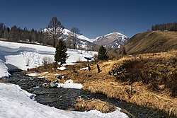
|image_caption = Kara-Koba River, [[Markakol Nature Reserve]] |
||
|image_flag = |
|image_flag = |
||
|flag_size = |
|flag_size = |
||
|image_seal = |
|image_seal = |
||
|seal_size = |
|seal_size = |
||
|image_shield = |
|image_shield =Katonaudanigerb.gif |
||
|shield_size = |
|shield_size = |
||
|image_blank_emblem |
|image_blank_emblem = |
||
|blank_emblem_size |
|blank_emblem_size = |
||
|image_map = Katonkaragay District Kazakhstan.png |
|image_map = Katonkaragay District Kazakhstan.png |
||
|mapsize = 300px |
|mapsize = 300px |
||
| Line 24: | Line 24: | ||
|mapsize1 = 150px |
|mapsize1 = 150px |
||
|map_caption1 = |
|map_caption1 = |
||
|pushpin_map = |
|pushpin_map = Continental Asia |
||
|pushpin_label_position = |
|pushpin_label_position = |
||
|subdivision_type = [[Countries of the world|Country]] |
|subdivision_type = [[Countries of the world|Country]] |
||
|subdivision_name = {{KAZ}} |
|subdivision_name = {{KAZ}} |
||
|subdivision_type1 = [[ |
|subdivision_type1 = [[Regions of Kazakhstan|Region]] |
||
|subdivision_name1 = [[East Kazakhstan |
|subdivision_name1 = [[East Kazakhstan Region]] |
||
|subdivision_type2 = [[Administrative center]] |
|subdivision_type2 = [[Administrative center]] |
||
|subdivision_name2 = [[ |
|subdivision_name2 = [[Katonkaragay]] |
||
|seat_type = |
|seat_type = |
||
|seat = |
|seat = |
||
|government_type = |
|government_type = |
||
|leader_title = |
|leader_title = [[Akim]] |
||
|leader_name = Calican Dildar Kalikanovich<ref>{{Cite web|url=https://www.gov.kz/memleket/entities/vko-katon-karagay/about?lang=ru|title=Акимат Катон-Карагайского района|website=www.gov.kz}}</ref> |
|||
| ⚫ | |||
|leader_title1 = <!-- for places with, say, both a mayor and a city manager --> |
|leader_title1 = <!-- for places with, say, both a mayor and a city manager --> |
||
|leader_name1 = |
|leader_name1 = |
||
|established_title = |
|established_title = Founded |
||
|established_date = 1928 |
|established_date = 1928 |
||
|area_magnitude = |
|area_magnitude = |
||
|unit_pref = |
|unit_pref =Metric |
||
|area_footnotes = |
|area_footnotes = |
||
|area_total_km2 = 13167 |
|area_total_km2 = 13167 |
||
| Line 55: | Line 55: | ||
|area_metro_km2 = |
|area_metro_km2 = |
||
|area_metro_sq_mi = |
|area_metro_sq_mi = |
||
|population_as_of = |
|population_as_of = 2013 |
||
|population_footnotes = <ref name="kz2013est"/> |
|||
|population_footnotes = <ref>[http://www.stat.kz/publishing/DocLib4/2010/%D0%94%D0%B5%D0%BC%D0%BE%D0%B3%D1%80%D0%B0%D1%84%D0%B8%D1%8F/h_sany2010_2kv%2016.08.rar The population of Kazakhstan by regions, cities and districts on July 1, 2010]</ref> |
|||
|population_note = |
|population_note = |
||
|population_total = |
|population_total = 28008 |
||
|population_density_km2 = |
|population_density_km2 = |
||
|population_density_sq_mi = |
|||
|population_metro = |
|population_metro = |
||
|population_density_metro_km2 = |
|population_density_metro_km2 = |
||
|population_density_metro_sq_mi = |
|||
|population_urban = |
|population_urban = |
||
|population_density_urban_km2 = |
|population_density_urban_km2 = |
||
| ⚫ | |||
|population_density_urban_mi2 = |
|||
| ⚫ | |||
| utc_offset = +6 |
| utc_offset = +6 |
||
|coordinates = {{coord|49.2113|N|84.5138|E|type:adm2nd_region:KZ|display=inline,title}} |
|||
|latd=|latm=|lats=|latNS= |
|||
|elevation_footnotes = |
|||
|longd=|longm=|longs= |longEW= |
|||
| ⚫ | |||
|elevation_footnotes = <!--for references: use <ref> </ref> tags--> |
|||
|elevation_m = |
|||
|elevation_ft = |
|elevation_ft = |
||
| |
|website = |
||
|postal_code = |
|||
|area_code = |
|||
|website = |
|||
|footnotes = |
|footnotes = |
||
}} |
}} |
||
{{Saka kurgans}} |
|||
'''Katonkaragay''', also spelled '''Katon-Karagay''' ({{langx|kk|Қатонқарағай ауданы|translit=Qatonqarağai audany}}) is a [[Districts of Kazakhstan|district]] of [[East Kazakhstan Region]] in eastern [[Kazakhstan]]. The administrative center of the district is the [[Village#Central and Eastern Europe|selo]] of [[Katonkaragay]].<ref>{{cite web |url=http://www.geonames.de/coukz-sub.html |title=Subdivisions of Kazakhstan in local languages |publisher=Geonames.de |date= |accessdate=2014-02-28 |archive-url=https://web.archive.org/web/20160303170443/http://www.geonames.de/coukz-sub.html |archive-date=2016-03-03 |url-status=dead }}</ref> It is the easternmost district in Kazakhstan. Population: {{Kz-population2013|28008|punct=;}} {{Kz-census2009|30,056|punct=;}} {{Kz-census1999|45,149|punct=.}} |
|||
==Berel burial mound== |
|||
'''Katonkaragay''', also spelled '''Katon-Karagay''' ({{lang-kz|''Қатонқарағай ауданы'' (''Katonqarahay audany'')}}) is a [[Districts of Kazakhstan|district]] of [[East Kazakhstan Province]] in eastern [[Kazakhstan]]. The administrative center of the district is [[Ulken Narym (Bolshenarymskoye)]] ({{coord|49.2113176|84.5137882|scale:20000|format=dms|display=inline|name=Bolshenarymskoye}}<ref> |
|||
| ⚫ | |||
[http://www.wikimapia.org/#lat=49.2113176&lon=84.5137882&z=14&l=9&m=s&v=9 Wikimapia location: Bolshenarymskoye]. |
|||
Near the selo of Berel ({{coord|49.3732082|86.4380264|scale:20000|format=dms|display=inline|name=Berel}}<ref>[http://www.wikimapia.org/#lat=49.3732082&lon=86.4380264&z=15&l=9&m=s&v=9] {{webarchive |url=https://web.archive.org/web/20070623073958/http://www.wikimapia.org/#lat=49.3732082&lon=86.4380264&z=15&l=9&m=s&v=9 |date=June 23, 2007 }}</ref>) excavations of ancient burial mounds have revealed artefacts the sophistication of which are encouraging a revaluation of the nomadic cultures of the 3rd and 4th centuries BC.<ref>{{cite news|url=https://www.nytimes.com/2012/03/13/science/from-their-graves-ancient-nomads-speak.html|title=Artifacts Show Sophistication of Ancient Nomads|newspaper=[[The New York Times]]|date=12 March 2012 |accessdate=2014-03-01|last1=Wilford |first1=John Noble }}</ref> |
|||
</ref>) ({{lang-kz|''Үлкен Нарым ауылы'' (''Ylken Narym auyly'')}}) town.<ref>[http://www.geonames.de/coukz-sub.html www.geonames.de Subdivisions of Kazakhstan in local languages]</ref> It is the eastern-most district in Kazakhstan. |
|||
Near the town of Berel ({{coord|49.3732082|86.4380264|scale:20000|format=dms|display=inline|name=Berel}}<ref> |
|||
[http://www.wikimapia.org/#lat=49.3732082&lon=86.4380264&z=15&l=9&m=s&v=9 Wikimapia location: Berel]. |
|||
</ref>) excavations of ancient burial mounds have revealed artefacts the sophistication of which are encouraging a revaluation of the nomadic cultures of the 3rd and 4th centuries BC<ref> |
|||
[http://www.nytimes.com/2012/03/13/science/from-their-graves-ancient-nomads-speak.html Artifacts Show Sophistication of Ancient Nomads]. |
|||
</ref>. |
|||
==References== |
==References== |
||
{{ |
{{Reflist}} |
||
==External links== |
==External links== |
||
*[http://katon-karagay.vko.gov.kz/kz/ Official Government Site of Katon-Karagay] |
*[http://katon-karagay.vko.gov.kz/kz/ Official Government Site of Katon-Karagay] |
||
{{East Kazakhstan |
{{East Kazakhstan Region}} |
||
{{Authority control}} |
|||
| ⚫ | |||
[[Category:Districts of Kazakhstan]] |
[[Category:Districts of Kazakhstan]] |
||
[[Category:East Kazakhstan |
[[Category:East Kazakhstan Region]] |
||
{{Kazakhstan-geo-stub}} |
{{Kazakhstan-geo-stub}} |
||
[[bg:Катон-Карагайски район]] |
|||
[[it:Distretto di Qatonqaraǧaj]] |
|||
[[kk:Катонқарағай ауданы]] |
|||
[[mk:Катонкарагај (округ)]] |
|||
[[ms:Daerah Katonkaragay]] |
|||
[[ru:Катон-Карагайский район]] |
|||
Latest revision as of 18:07, 10 November 2024
Katonkaragay | |
|---|---|
District | |
| Катонқарағай ауданы Катон-Карагайский район | |
 Kara-Koba River, Markakol Nature Reserve | |
 | |
| Coordinates: 49°12′41″N 84°30′50″E / 49.2113°N 84.5138°E | |
| Country | |
| Region | East Kazakhstan Region |
| Administrative center | Katonkaragay |
| Founded | 1928 |
| Government | |
| • Akim | Calican Dildar Kalikanovich[1] |
| Area | |
• Total | 13,167 km2 (5,084 sq mi) |
| Population (2013)[2] | |
• Total | 28,008 |
| Time zone | UTC+6 (East) |
| Saka kurgans[3] | ||||||||||||||||||||||||||||||
|---|---|---|---|---|---|---|---|---|---|---|---|---|---|---|---|---|---|---|---|---|---|---|---|---|---|---|---|---|---|---|
|
||||||||||||||||||||||||||||||
Katonkaragay, also spelled Katon-Karagay (Kazakh: Қатонқарағай ауданы, romanized: Qatonqarağai audany) is a district of East Kazakhstan Region in eastern Kazakhstan. The administrative center of the district is the selo of Katonkaragay.[4] It is the easternmost district in Kazakhstan. Population: 28,008 (2013 estimate);[2] 30,056 (2009 Census results);[5] 45,149 (1999 Census results).[5]
Berel burial mound
[edit]Near the selo of Berel (49°22′24″N 86°26′17″E / 49.3732082°N 86.4380264°E[6]) excavations of ancient burial mounds have revealed artefacts the sophistication of which are encouraging a revaluation of the nomadic cultures of the 3rd and 4th centuries BC.[7]
References
[edit]- ^ "Акимат Катон-Карагайского района". www.gov.kz.
- ^ a b "Население Республики Казахстан" (in Russian). Департамент социальной и демографической статистики. Retrieved 27 December 2013.
- ^ Image file with complete data, Amir, Saltanat; Roberts, Rebecca C. (2023). "The Saka 'Animal Style' in Context: Material, Technology, Form and Use". Arts. 12: 23. doi:10.3390/arts12010023.
- ^ "Subdivisions of Kazakhstan in local languages". Geonames.de. Archived from the original on 2016-03-03. Retrieved 2014-02-28.
- ^ a b "Население Республики Казахстан" [Population of the Republic of Kazakhstan] (in Russian). Департамент социальной и демографической статистики. Retrieved 8 December 2013.
- ^ [1] Archived June 23, 2007, at the Wayback Machine
- ^ Wilford, John Noble (12 March 2012). "Artifacts Show Sophistication of Ancient Nomads". The New York Times. Retrieved 2014-03-01.
External links
[edit]


