San Salvador and Rum Cay: Difference between revisions
Appearance
Content deleted Content added
geostubbed |
No edit summary |
||
| (22 intermediate revisions by 21 users not shown) | |||
| Line 1: | Line 1: | ||
{{Short description|Former Bahamas district}} |
|||
| ⚫ | |||
{{More citations needed|date=September 2024}} |
|||
| ⚫ | |||
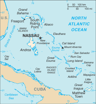
'''San Salvador and Rum Cay''' |
'''San Salvador and Rum Cay''' is a former [[Districts of the Bahamas|district of the Bahamas]]. |
||
The Main settlement in Rum Cay is [[Port Nelson, Bahamas|Port Nelson]]. |
|||
In 1977, the district was estimated to be home to 860 people.<ref>{{Cite book |last=United States. |first=Department of State |url=https://books.google.com/books?id=mKNqAAAAMAAJ&pg=PP4&dq=%22San+Salvador+and+Rum+Cay%22&hl=en&newbks=1&newbks_redir=0&sa=X&ved=2ahUKEwjPlL2QktuJAxXmhIkEHUoKGAoQ6AF6BAgIEAI#v=onepage&q=%22San%20Salvador%20and%20Rum%20Cay%22&f=false |title=Bahamas: Post Report |publisher=U.S. Government Printing Office |year=1977 |pages=2}}</ref> In 1996 it was divided into separate districts of [[San Salvador Island|San Salvador]] and [[Rum Cay]].<ref>{{Cite book |last=Law |first=Gwillim |url=https://books.google.com/books?id=nXCeCQAAQBAJ |title=Administrative Subdivisions of Countries: A Comprehensive World Reference, 1900 through 1998 |date=2015-05-20 |publisher=McFarland |isbn=978-1-4766-0447-3 |pages=42 |language=en}}</ref> |
|||
==References== |
|||
In [[1996]] it was divided into separate districts of [[San Salvador Island|San Salvador]] and [[Rum Cay]]. |
|||
{{reflist}} |
|||
{{Coord|23|51|N|74|40|W|region:BS_type:adm1st|display=title}} |
|||
| ⚫ | |||
| ⚫ | |||
{{DEFAULTSORT:San Salvador And Rum Cay}} |
|||
| ⚫ | |||
| ⚫ | |||
Latest revision as of 06:03, 14 November 2024
This article needs additional citations for verification. (September 2024) |
San Salvador and Rum Cay is a former district of the Bahamas. The Main settlement in Rum Cay is Port Nelson. In 1977, the district was estimated to be home to 860 people.[1] In 1996 it was divided into separate districts of San Salvador and Rum Cay.[2]
References
[edit]- ^ United States., Department of State (1977). Bahamas: Post Report. U.S. Government Printing Office. p. 2.
- ^ Law, Gwillim (2015-05-20). Administrative Subdivisions of Countries: A Comprehensive World Reference, 1900 through 1998. McFarland. p. 42. ISBN 978-1-4766-0447-3.
23°51′N 74°40′W / 23.850°N 74.667°W

